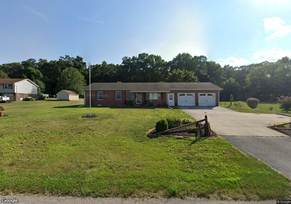
315 Deagen Rd Hanover, PA 17331
Estimated Value: $253,000 - $326,000
3
Beds
2
Baths
1,380
Sq Ft
$207/Sq Ft
Est. Value
About This Home
This home is located at 315 Deagen Rd, Hanover, PA 17331 and is currently estimated at $285,552, approximately $206 per square foot. 315 Deagen Rd is a home located in York County with nearby schools including Spring Grove Area Middle School, Spring Grove Area High School, and Hope Christian School Of Hanover.
Ownership History
Date
Name
Owned For
Owner Type
Purchase Details
Closed on
Jul 30, 1999
Sold by
Shorb Richard and Shorb Irene L
Bought by
Plitt Paul E and Plitt Betty R
Current Estimated Value
Home Financials for this Owner
Home Financials are based on the most recent Mortgage that was taken out on this home.
Original Mortgage
$13,500
Outstanding Balance
$3,846
Interest Rate
7.54%
Mortgage Type
Seller Take Back
Estimated Equity
$281,706
Create a Home Valuation Report for This Property
The Home Valuation Report is an in-depth analysis detailing your home's value as well as a comparison with similar homes in the area
Home Values in the Area
Average Home Value in this Area
Purchase History
| Date | Buyer | Sale Price | Title Company |
|---|---|---|---|
| Plitt Paul E | $123,500 | -- |
Source: Public Records
Mortgage History
| Date | Status | Borrower | Loan Amount |
|---|---|---|---|
| Open | Plitt Paul E | $13,500 |
Source: Public Records
Tax History Compared to Growth
Tax History
| Year | Tax Paid | Tax Assessment Tax Assessment Total Assessment is a certain percentage of the fair market value that is determined by local assessors to be the total taxable value of land and additions on the property. | Land | Improvement |
|---|---|---|---|---|
| 2025 | $4,925 | $146,560 | $43,190 | $103,370 |
| 2024 | $4,872 | $146,560 | $43,190 | $103,370 |
| 2023 | $4,872 | $146,560 | $43,190 | $103,370 |
| 2022 | $4,872 | $146,560 | $43,190 | $103,370 |
| 2021 | $4,663 | $146,560 | $43,190 | $103,370 |
| 2020 | $4,663 | $146,560 | $43,190 | $103,370 |
| 2019 | $4,564 | $146,560 | $43,190 | $103,370 |
| 2018 | $4,503 | $146,560 | $43,190 | $103,370 |
| 2017 | $4,364 | $146,560 | $43,190 | $103,370 |
| 2016 | -- | $146,560 | $43,190 | $103,370 |
| 2015 | $2,959 | $146,560 | $43,190 | $103,370 |
| 2014 | $2,959 | $146,560 | $43,190 | $103,370 |
Source: Public Records
Map
Nearby Homes
- 125 Northview Dr
- 6 Amanda Ave
- 1120 Hoff Rd
- 758 Bankert Rd
- 1010 Marietta Ave
- 366 Jasmine Dr
- 345 Jasmine Dr
- 265 Breezewood Dr
- 113 Timber Ln
- 2287 Grandview Rd
- 36 Overlook Dr
- 32 Magnolia Ln
- 2 Astoria Dr
- 103 Overlook Dr
- 208 Overlook Dr
- 501 Charles Ave
- 1844 Liberty Rd
- 28 Brookside Ave
- 139 Mussetta St
- 194 Center St Unit 194
- 325 Deagen Rd
- 310 Deagen Rd
- 295 Deagen Rd
- 320 Deagen Rd
- 345 Deagen Rd
- 350 Deagen Rd
- 300 Deagen Rd
- 275 Deagen Rd
- 270 Deagen Rd
- 250 Deagen Rd
- 250 Deagen Rd
- 330 Deagen Rd
- 400 Deagen Rd
- 417 Deagen Rd
- 0 Lt 49a Birch Dr Unit 49 20801494
- Lt 9 Pamadeva Rd
- Parcel 115 Fuhrman Mill Rd
- Phase 1 S Riding Subdivision Unit 1
- Lot 14 Martz Ln
- Lot 13 Martz Ln