Estimated Value: $102,000 - $170,000
4
Beds
2
Baths
1,383
Sq Ft
$108/Sq Ft
Est. Value
About This Home
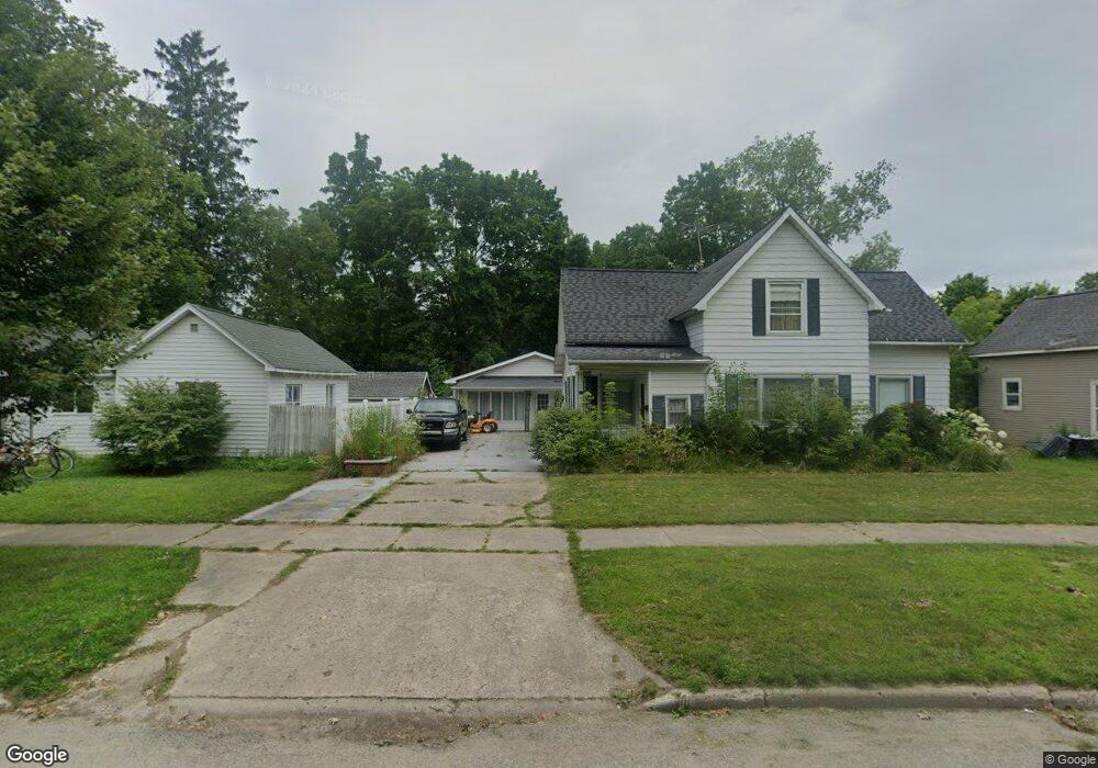
This home is located at 315 E Grant St, Caro, MI 48723 and is currently estimated at $149,079, approximately $107 per square foot. 315 E Grant St is a home with nearby schools including McComb Elementary School, Schall Elementary School, and Caro Middle School.
Ownership History
Date
Name
Owned For
Owner Type
Purchase Details
Closed on
Jun 13, 2025
Sold by
Porritt Tanya L and Mcintosh Troy L
Bought by
Allbee Garrett and Allbee Hope
Current Estimated Value
Home Financials for this Owner
Home Financials are based on the most recent Mortgage that was taken out on this home.
Original Mortgage
$174,775
Outstanding Balance
$173,550
Interest Rate
6.76%
Mortgage Type
FHA
Estimated Equity
-$24,471
Purchase Details
Closed on
Jan 23, 2025
Sold by
Mcintosh Robert A
Bought by
Mcintosh Marsha Lynn
Purchase Details
Closed on
Dec 9, 2024
Sold by
Mcintosh Robert
Bought by
Mcintosh Robert and Porritt Tanya L
Purchase Details
Closed on
Mar 25, 2022
Sold by
Putnam Aaron L
Bought by
Mcintosh Robert
Purchase Details
Closed on
Jan 24, 2020
Sold by
Putnam Peter W and Putnam June S
Bought by
Crossett Melody A and Putnam Daniel J
Purchase Details
Closed on
Aug 8, 2016
Sold by
Putnam Peter W and Putnam June S
Bought by
Putnam Peter W and Putnam June S
Create a Home Valuation Report for This Property
The Home Valuation Report is an in-depth analysis detailing your home's value as well as a comparison with similar homes in the area
Home Values in the Area
Average Home Value in this Area
Purchase History
| Date | Buyer | Sale Price | Title Company |
|---|---|---|---|
| Allbee Garrett | $178,000 | None Listed On Document | |
| Allbee Garrett | $178,000 | None Listed On Document | |
| Mcintosh Marsha Lynn | -- | None Listed On Document | |
| Mcintosh Robert | -- | None Listed On Document | |
| Mcintosh Robert | $120,000 | None Listed On Document | |
| Crossett Melody A | -- | None Available | |
| Putnam Peter W | -- | None Available | |
| Putnam Peter W | -- | None Available |
Source: Public Records
Mortgage History
| Date | Status | Borrower | Loan Amount |
|---|---|---|---|
| Open | Allbee Garrett | $174,775 | |
| Closed | Allbee Garrett | $174,775 |
Source: Public Records
Tax History
| Year | Tax Paid | Tax Assessment Tax Assessment Total Assessment is a certain percentage of the fair market value that is determined by local assessors to be the total taxable value of land and additions on the property. | Land | Improvement |
|---|---|---|---|---|
| 2025 | $2,925 | $68,500 | $0 | $0 |
| 2024 | $2,925 | $69,000 | $0 | $0 |
| 2023 | $2,787 | $63,000 | $0 | $0 |
| 2022 | $1,381 | $49,200 | $0 | $0 |
| 2021 | $1,337 | $43,300 | $0 | $0 |
| 2020 | $1,319 | $42,300 | $0 | $0 |
| 2019 | $1,293 | $39,800 | $0 | $0 |
| 2018 | $1,267 | $35,700 | $0 | $0 |
| 2017 | $1,241 | $32,200 | $0 | $0 |
| 2016 | $1,192 | $27,700 | $0 | $0 |
| 2015 | $7 | $29,100 | $0 | $0 |
| 2014 | $7 | $27,500 | $0 | $0 |
| 2013 | $5 | $27,200 | $0 | $0 |
Source: Public Records
Map
Nearby Homes
- 309 E Grant St
- 321 E Grant St
- 303 E Grant St
- 549 E Frank St
- 520 Ward St
- 312 E Grant St
- 318 E Grant St
- 306 E Grant St
- 300 E Grant St
- 524 Ward St
- 332 E Bush St
- 243 E Grant St
- 531 E Frank St
- 246 E Grant St
- 548 E Frank St Unit 552
- 548 E Frank St
- 319 E Bush St
- 604 E Frank St
- 263 E Sherman St
- 331 E Bush St
Your Personal Tour Guide
Ask me questions while you tour the home.