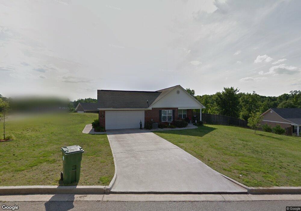
315 Frick Ln Grovetown, GA 30813
Estimated Value: $242,000 - $250,000
3
Beds
2
Baths
1,380
Sq Ft
$178/Sq Ft
Est. Value
About This Home
This home is located at 315 Frick Ln, Grovetown, GA 30813 and is currently estimated at $245,467, approximately $177 per square foot. 315 Frick Ln is a home located in Columbia County with nearby schools including Baker Place Elementary School and Grovetown High School.
Ownership History
Date
Name
Owned For
Owner Type
Purchase Details
Closed on
Jan 4, 2021
Sold by
Mcnevin April
Bought by
Mcnevin April and Mcnevin Andrew P
Current Estimated Value
Purchase Details
Closed on
Feb 9, 2007
Sold by
B Kay Bldrs Corp
Bought by
Krentler April M
Home Financials for this Owner
Home Financials are based on the most recent Mortgage that was taken out on this home.
Original Mortgage
$102,675
Interest Rate
6.17%
Mortgage Type
New Conventional
Purchase Details
Closed on
Jul 22, 2005
Sold by
Lewiston Road Investment G
Bought by
B Kay Builders Corp
Create a Home Valuation Report for This Property
The Home Valuation Report is an in-depth analysis detailing your home's value as well as a comparison with similar homes in the area
Home Values in the Area
Average Home Value in this Area
Purchase History
| Date | Buyer | Sale Price | Title Company |
|---|---|---|---|
| Mcnevin April | -- | -- | |
| Krentler April M | $136,900 | -- | |
| B Kay Builders Corp | $639,200 | -- |
Source: Public Records
Mortgage History
| Date | Status | Borrower | Loan Amount |
|---|---|---|---|
| Previous Owner | Krentler April M | $102,675 |
Source: Public Records
Tax History Compared to Growth
Tax History
| Year | Tax Paid | Tax Assessment Tax Assessment Total Assessment is a certain percentage of the fair market value that is determined by local assessors to be the total taxable value of land and additions on the property. | Land | Improvement |
|---|---|---|---|---|
| 2024 | $2,377 | $92,797 | $17,904 | $74,893 |
| 2023 | $2,377 | $80,921 | $16,004 | $64,917 |
| 2022 | $1,900 | $70,858 | $13,904 | $56,954 |
| 2021 | $1,807 | $64,304 | $14,104 | $50,200 |
| 2020 | $1,853 | $64,630 | $12,604 | $52,026 |
| 2019 | $1,755 | $61,072 | $12,104 | $48,968 |
| 2018 | $1,624 | $56,189 | $11,204 | $44,985 |
| 2017 | $1,733 | $59,896 | $11,504 | $48,392 |
| 2016 | $1,502 | $53,542 | $10,080 | $43,462 |
| 2015 | $1,464 | $52,014 | $10,580 | $41,434 |
| 2014 | $1,456 | $51,084 | $10,180 | $40,904 |
Source: Public Records
Map
Nearby Homes
- 321 Frick Ln
- 1446 Sawmill Trail
- 5164 Thoroughbred Way
- 5174 Bluegrass Trail
- 415 Lewiston Rd
- 5160 Thoroughbred Way
- 4131 Chastain Dr
- 220 Havelock Dr
- 4061 Ellington Dr
- 781 Herrington Dr
- 4044 Ellington Dr
- 153 Brighton Landing Dr
- 3906 Berkshire Way
- 4010 Ellington Dr
- 1270 Cobblefield Dr
- 1218 Absolon Ct
- 337 Brentford Ave
- 1214 Absolon Ct
- 1915 Butternut Dr Unit 17A
- 1246 Cobblefield Dr