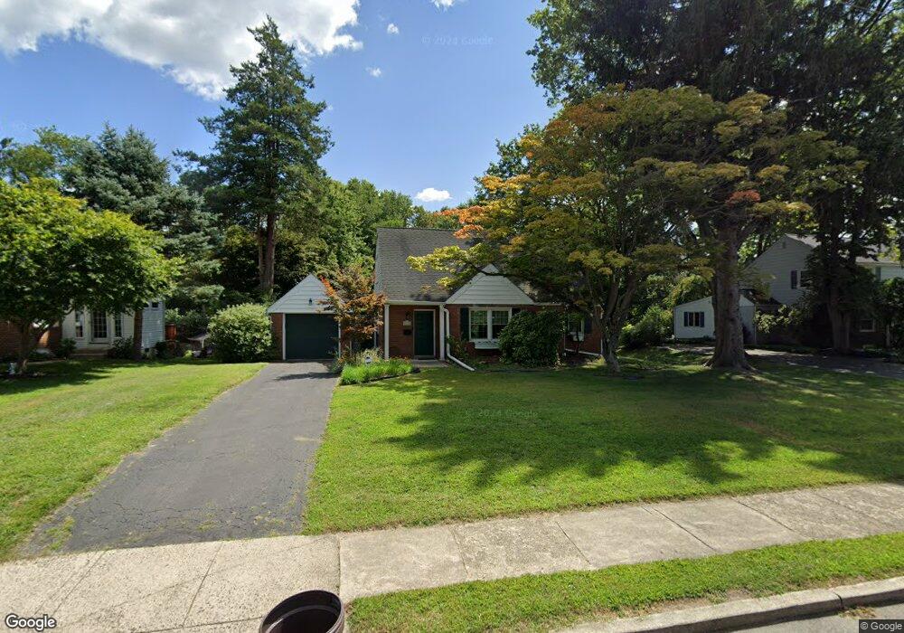
315 Lewis Rd Broomall, PA 19008
Estimated Value: $455,000 - $575,000
3
Beds
2
Baths
1,571
Sq Ft
$322/Sq Ft
Est. Value
About This Home
This home is located at 315 Lewis Rd, Broomall, PA 19008 and is currently estimated at $505,874, approximately $322 per square foot. 315 Lewis Rd is a home located in Delaware County with nearby schools including Russell Elementary School, Paxon Hollow Middle School, and Marple Newtown Senior High School.
Ownership History
Date
Name
Owned For
Owner Type
Purchase Details
Closed on
Jun 6, 2003
Sold by
Ling Chunnan and Yuan Shulin
Bought by
Mchale Michael H and Ferraro Mchale Kristen A
Current Estimated Value
Home Financials for this Owner
Home Financials are based on the most recent Mortgage that was taken out on this home.
Original Mortgage
$206,000
Outstanding Balance
$90,565
Interest Rate
5.83%
Mortgage Type
Purchase Money Mortgage
Estimated Equity
$415,309
Purchase Details
Closed on
Sep 2, 1994
Sold by
Granger Jeffrey B and Granger Katherine Lang
Bought by
Ling Chunnan and Yuan Shulin
Home Financials for this Owner
Home Financials are based on the most recent Mortgage that was taken out on this home.
Original Mortgage
$120,000
Interest Rate
8.54%
Create a Home Valuation Report for This Property
The Home Valuation Report is an in-depth analysis detailing your home's value as well as a comparison with similar homes in the area
Home Values in the Area
Average Home Value in this Area
Purchase History
| Date | Buyer | Sale Price | Title Company |
|---|---|---|---|
| Mchale Michael H | $257,500 | Commonwealth Land Title Insu | |
| Ling Chunnan | $161,000 | Commonwealth Land Title Ins |
Source: Public Records
Mortgage History
| Date | Status | Borrower | Loan Amount |
|---|---|---|---|
| Open | Mchale Michael H | $206,000 | |
| Previous Owner | Ling Chunnan | $120,000 | |
| Closed | Mchale Michael H | $38,625 |
Source: Public Records
Tax History Compared to Growth
Tax History
| Year | Tax Paid | Tax Assessment Tax Assessment Total Assessment is a certain percentage of the fair market value that is determined by local assessors to be the total taxable value of land and additions on the property. | Land | Improvement |
|---|---|---|---|---|
| 2025 | $5,124 | $296,510 | $114,350 | $182,160 |
| 2024 | $5,124 | $296,510 | $114,350 | $182,160 |
| 2023 | $4,961 | $296,510 | $114,350 | $182,160 |
| 2022 | $4,868 | $296,510 | $114,350 | $182,160 |
| 2021 | $7,346 | $296,510 | $114,350 | $182,160 |
| 2020 | $4,063 | $141,200 | $58,360 | $82,840 |
| 2019 | $4,014 | $141,200 | $58,360 | $82,840 |
| 2018 | $3,973 | $141,200 | $0 | $0 |
| 2017 | $3,975 | $141,200 | $0 | $0 |
| 2016 | $775 | $141,200 | $0 | $0 |
| 2015 | $775 | $141,200 | $0 | $0 |
| 2014 | $775 | $141,200 | $0 | $0 |
Source: Public Records
Map
Nearby Homes
- 310 Lewis Rd
- 2606 Springfield Rd
- 132 S Sproul Rd
- 2119 Boxwood Dr
- 126 1st Ave
- 2611 Woodberry Rd
- 0 Cedar Grove Rd Unit PADE2105298
- 11 Linden Dr
- 2025 S Sproul Rd
- 106 2nd Ave
- 301 S New Ardmore Ave
- 88 4th Ave
- 50 Schoolhouse Ln
- 2613 Caranel Rd
- 2500 Grant Rd
- 15 Oakland Rd
- Lot1 Cynwyd
- 2839 Springfield Rd
- Lot 2 Cynwyd
- 106 Gibson Ct