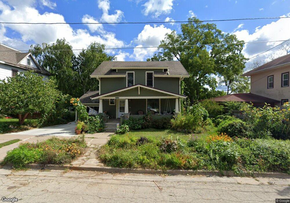
315 N Dunlap Ave Viroqua, WI 54665
Estimated Value: $182,000 - $310,000
--
Bed
--
Bath
--
Sq Ft
8,712
Sq Ft Lot
About This Home
This home is located at 315 N Dunlap Ave, Viroqua, WI 54665 and is currently estimated at $252,835. 315 N Dunlap Ave is a home located in Vernon County with nearby schools including Viroqua Elementary School, Viroqua Middle School, and Viroqua High School.
Ownership History
Date
Name
Owned For
Owner Type
Purchase Details
Closed on
Jul 26, 2023
Sold by
Romary David K
Bought by
Romary David K
Current Estimated Value
Purchase Details
Closed on
Sep 9, 2005
Sold by
Suiter Ardell J and Suiter Shelly J
Bought by
Romary David K and Schneeberg Antoinette M
Home Financials for this Owner
Home Financials are based on the most recent Mortgage that was taken out on this home.
Original Mortgage
$58,400
Interest Rate
5.44%
Mortgage Type
New Conventional
Create a Home Valuation Report for This Property
The Home Valuation Report is an in-depth analysis detailing your home's value as well as a comparison with similar homes in the area
Home Values in the Area
Average Home Value in this Area
Purchase History
| Date | Buyer | Sale Price | Title Company |
|---|---|---|---|
| Romary David K | $74,550 | Cole I Agar | |
| Romary David K | $73,000 | -- |
Source: Public Records
Mortgage History
| Date | Status | Borrower | Loan Amount |
|---|---|---|---|
| Previous Owner | Romary David K | $58,400 |
Source: Public Records
Tax History Compared to Growth
Tax History
| Year | Tax Paid | Tax Assessment Tax Assessment Total Assessment is a certain percentage of the fair market value that is determined by local assessors to be the total taxable value of land and additions on the property. | Land | Improvement |
|---|---|---|---|---|
| 2024 | $3,190 | $137,900 | $17,200 | $120,700 |
| 2023 | $2,308 | $117,600 | $17,200 | $100,400 |
| 2022 | $2,637 | $117,600 | $17,200 | $100,400 |
| 2021 | $2,514 | $117,600 | $17,200 | $100,400 |
| 2020 | $2,465 | $117,600 | $17,200 | $100,400 |
| 2019 | $2,427 | $117,600 | $17,200 | $100,400 |
| 2018 | $2,043 | $87,700 | $13,200 | $74,500 |
| 2017 | $1,985 | $87,700 | $13,200 | $74,500 |
| 2016 | $1,997 | $87,700 | $13,200 | $74,500 |
| 2015 | $2,280 | $87,700 | $13,200 | $74,500 |
| 2014 | $1,970 | $87,700 | $13,200 | $74,500 |
| 2013 | $2,017 | $87,700 | $13,200 | $74,500 |
Source: Public Records
Map
Nearby Homes
- 222 W Decker St
- 313 N Main St
- 220 W Broadway St
- 729 N Main St
- 756 N Main St
- 231 S Rusk Ave
- 401 Fairview Dr
- 651 E Decker St
- 000 Abbey Ln
- 130 W Maple St
- 125 N Lincoln Ave
- 720 S Main St
- 727 Garfield Ave
- 208 Circle Dr S
- 115 Crestline St
- 1 Sandy Oak Dr
- 912 Silverthorne Dr
- S5117 County Road Nn
- 914 Silverthorne Dr
- 807 S Main St
- 305 N Dunlap Ave
- 321 N Dunlap Ave
- 322 N Dunlap Ave
- 306 N Dunlap Ave
- 303 N Dunlap Ave
- 322 N Rock Ave
- 314 N Rock Ave
- 327 N Dunlap Ave
- 304 W Gillette St
- 402 N Rock Ave
- 219 N Dunlap Ave
- 413 N Dunlap Ave
- 411 N Dunlap Ave
- 410 N Dunlap Ave
- 308 W Gillette St
- 412 N Rock Ave
- 217 N Dunlap Ave
- 220 N Rock Ave
- 412 N Dunlap Ave
- 315 Minshall Ave