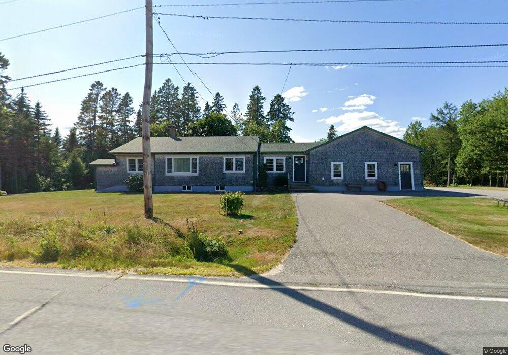
315 Point St Addison, ME 04606
Estimated Value: $139,000 - $319,000
2
Beds
2
Baths
1,176
Sq Ft
$181/Sq Ft
Est. Value
About This Home
This home is located at 315 Point St, Addison, ME 04606 and is currently estimated at $213,372, approximately $181 per square foot. 315 Point St is a home.
Ownership History
Date
Name
Owned For
Owner Type
Purchase Details
Closed on
Sep 22, 2020
Sold by
Davis Louis B
Bought by
Prout Troy M and Prout Robin L
Current Estimated Value
Purchase Details
Closed on
Jan 26, 2015
Sold by
Candee David W
Bought by
Prout Troy M and Prout Robin L
Create a Home Valuation Report for This Property
The Home Valuation Report is an in-depth analysis detailing your home's value as well as a comparison with similar homes in the area
Home Values in the Area
Average Home Value in this Area
Purchase History
| Date | Buyer | Sale Price | Title Company |
|---|---|---|---|
| Prout Troy M | -- | None Available | |
| Prout Troy M | -- | -- |
Source: Public Records
Tax History Compared to Growth
Tax History
| Year | Tax Paid | Tax Assessment Tax Assessment Total Assessment is a certain percentage of the fair market value that is determined by local assessors to be the total taxable value of land and additions on the property. | Land | Improvement |
|---|---|---|---|---|
| 2024 | $2,819 | $150,600 | $25,200 | $125,400 |
| 2023 | $2,593 | $150,600 | $25,200 | $125,400 |
| 2022 | $2,480 | $149,400 | $24,000 | $125,400 |
| 2021 | $1,723 | $103,800 | $24,000 | $79,800 |
| 2020 | $1,634 | $102,100 | $22,300 | $79,800 |
| 2019 | $1,623 | $102,100 | $22,300 | $79,800 |
| 2018 | $1,623 | $102,100 | $22,300 | $79,800 |
| 2017 | $1,623 | $102,100 | $22,300 | $79,800 |
| 2016 | $1,152 | $78,900 | $22,300 | $56,600 |
| 2015 | $1,132 | $78,900 | $22,300 | $56,600 |
| 2014 | $1,307 | $97,500 | $22,300 | $75,200 |
| 2013 | $1,219 | $97,500 | $22,300 | $75,200 |
Source: Public Records
Map
Nearby Homes
- 330 Point St
- 3 Riverview Ln
- 361 Water St
- 126 Point St
- 75 Point St
- M4L1 Addison Rd
- 61 Point St
- 1 E Side Rd
- 51 Point St
- p/o 120 Wescogus Rd
- p/o Lot 78 Wescogus Rd
- 386 Indian River Rd
- 23 Addison Rd
- Lot #7 Highland Rd
- Lot 3 W McMann & Porcupine Hill Rd
- 337 W Side Rd
- Lot 13-1 W McMann & Meadow Roads
- 16 & 18 Nelson Way
- M5L42 Hook Rd
- M9 L9C Black Bear Ln
- 314 Point St
- 308 Point St
- 333 Point St
- 341 Point St
- 342 Point St
- 278 Point St
- 275 Point St
- 360 Point St
- 0 Point St Unit 467267
- 0 Point St Unit 452155
- 0 Point St Unit 300391
- 0 Point St Unit 1472846
- Lot 2 Point St
- 0 Point St Unit 1071166
- 357 Point St
- 4 Bunny Trl Ln
- 1 Pleasant View Ct
- 427 Point St
- 426 Point St
- 440 Point St