Estimated Value: $113,660 - $142,000
2
Beds
1
Bath
828
Sq Ft
$152/Sq Ft
Est. Value
About This Home
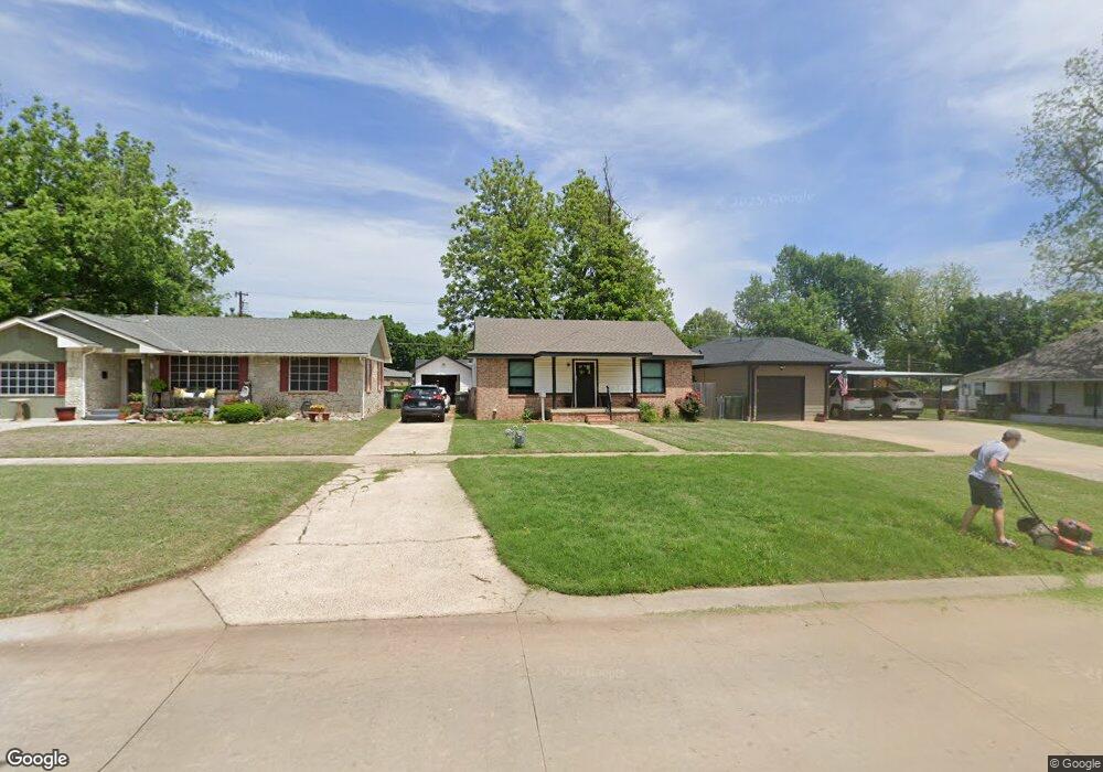
This home is located at 315 Poplar Ave, Yukon, OK 73099 and is currently estimated at $125,915, approximately $152 per square foot. 315 Poplar Ave is a home located in Canadian County with nearby schools including Central Elementary School, Independence Elementary School, and Yukon Middle School.
Ownership History
Date
Name
Owned For
Owner Type
Purchase Details
Closed on
Feb 14, 2024
Sold by
Carl Wright Trust and Nelva Wright Trust
Bought by
Kimmel Jacob William
Current Estimated Value
Purchase Details
Closed on
Dec 14, 2023
Sold by
Carl Wright Revoc Liv Tr
Bought by
Kimmel Jacob William
Purchase Details
Closed on
Dec 30, 1999
Sold by
Wright Robert and Nelda Jean
Purchase Details
Closed on
Nov 10, 1999
Sold by
Wright Carl and Nelva Joy
Purchase Details
Closed on
Feb 5, 1990
Bought by
Wright,Carl Trustee Of The
Create a Home Valuation Report for This Property
The Home Valuation Report is an in-depth analysis detailing your home's value as well as a comparison with similar homes in the area
Home Values in the Area
Average Home Value in this Area
Purchase History
| Date | Buyer | Sale Price | Title Company |
|---|---|---|---|
| Kimmel Jacob William | -- | None Listed On Document | |
| Kimmel Jacob William | -- | None Listed On Document | |
| Kimmel Jacob William | $90,000 | None Listed On Document | |
| -- | -- | -- | |
| -- | -- | -- | |
| Wright,Carl Trustee Of The | -- | -- |
Source: Public Records
Tax History Compared to Growth
Tax History
| Year | Tax Paid | Tax Assessment Tax Assessment Total Assessment is a certain percentage of the fair market value that is determined by local assessors to be the total taxable value of land and additions on the property. | Land | Improvement |
|---|---|---|---|---|
| 2024 | $784 | $7,453 | $1,382 | $6,071 |
| 2023 | $784 | $7,237 | $1,382 | $5,855 |
| 2022 | $750 | $6,893 | $1,382 | $5,511 |
| 2021 | $717 | $6,565 | $1,375 | $5,190 |
| 2020 | $674 | $6,252 | $1,361 | $4,891 |
| 2019 | $644 | $5,954 | $1,353 | $4,601 |
| 2018 | $615 | $5,671 | $1,320 | $4,351 |
| 2017 | $586 | $5,400 | $1,228 | $4,172 |
| 2016 | $558 | $5,401 | $1,249 | $4,152 |
| 2015 | -- | $4,898 | $1,058 | $3,840 |
| 2014 | -- | $4,665 | $942 | $3,723 |
Source: Public Records
Map
Nearby Homes
- 11817 Corie Nicole Ln
- 4601 Grassland Dr
- 12033 SW 31st St
- 3608 Northover Ridge Dr
- 3509 Sawtooth Ridge Dr
- 10401 NW 33rd St
- 11020 SW 34th Terrace
- 502 Walnut Ave
- 2117 Aminas Way
- 621 Yukon Ave
- 601 S 8th St
- 600 S 8th St
- 11200 SW 32nd St
- 616 Kingston Dr
- 2001 Aminas Way
- 11033 NW 20th Terrace
- 12100 Birch Ave
- 12201 Birch Ave
- 210 N 4th St
- 705 Yukon Ave