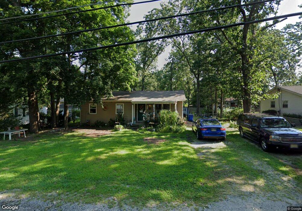
315 Rhode Island Rd Browns Mills, NJ 08015
Estimated Value: $229,684 - $300,000
--
Bed
--
Bath
1,004
Sq Ft
$262/Sq Ft
Est. Value
About This Home
This home is located at 315 Rhode Island Rd, Browns Mills, NJ 08015 and is currently estimated at $263,171, approximately $262 per square foot. 315 Rhode Island Rd is a home located in Burlington County.
Ownership History
Date
Name
Owned For
Owner Type
Purchase Details
Closed on
Sep 26, 1997
Sold by
Hud
Bought by
Carter Keith M
Current Estimated Value
Home Financials for this Owner
Home Financials are based on the most recent Mortgage that was taken out on this home.
Original Mortgage
$48,900
Outstanding Balance
$7,905
Interest Rate
7.52%
Mortgage Type
FHA
Estimated Equity
$255,266
Purchase Details
Closed on
Jun 9, 1997
Sold by
Daniels Gary L
Bought by
Hud
Home Financials for this Owner
Home Financials are based on the most recent Mortgage that was taken out on this home.
Original Mortgage
$179,646
Interest Rate
7.7%
Create a Home Valuation Report for This Property
The Home Valuation Report is an in-depth analysis detailing your home's value as well as a comparison with similar homes in the area
Home Values in the Area
Average Home Value in this Area
Purchase History
| Date | Buyer | Sale Price | Title Company |
|---|---|---|---|
| Carter Keith M | $49,000 | Surety Title Corporation | |
| Hud | -- | -- |
Source: Public Records
Mortgage History
| Date | Status | Borrower | Loan Amount |
|---|---|---|---|
| Open | Carter Keith M | $48,900 | |
| Previous Owner | Hud | $179,646 |
Source: Public Records
Tax History Compared to Growth
Tax History
| Year | Tax Paid | Tax Assessment Tax Assessment Total Assessment is a certain percentage of the fair market value that is determined by local assessors to be the total taxable value of land and additions on the property. | Land | Improvement |
|---|---|---|---|---|
| 2025 | $4,340 | $141,600 | $38,000 | $103,600 |
| 2024 | $4,072 | $141,600 | $38,000 | $103,600 |
| 2023 | $4,072 | $141,600 | $38,000 | $103,600 |
| 2022 | $3,769 | $141,600 | $38,000 | $103,600 |
| 2021 | $3,367 | $141,600 | $38,000 | $103,600 |
| 2020 | $3,479 | $141,600 | $38,000 | $103,600 |
| 2019 | $3,332 | $141,600 | $38,000 | $103,600 |
| 2018 | $3,219 | $141,600 | $38,000 | $103,600 |
| 2017 | $3,152 | $141,600 | $38,000 | $103,600 |
| 2016 | $2,792 | $74,700 | $20,800 | $53,900 |
| 2015 | $2,770 | $74,700 | $20,800 | $53,900 |
| 2014 | $2,648 | $74,700 | $20,800 | $53,900 |
Source: Public Records
Map
Nearby Homes
- 327 W Virginia Rd
- 5 Maryland Trail
- 402 Virginia Dr
- 1203 Connecticut Rd
- 0 Indiana Trail
- 411 Virginia Dr
- 108 Louisiana Trail
- 515 W Virginia Rd
- 120 Alabama Trail
- 515 New Jersey Rd
- 513 Louisiana Trail
- 518 Louisiana Trail
- 106 Florida Trail
- 209 Colorado Trail
- 307 Colorado Trail
- 317 Colorado Trail
- 310 Piute Trail
- 315 Algonquin Trail
- 5 Pea Patch Rd
- 317 Cayuga Trail
- 311 Rhode Island Rd
- 319 Rhode Island Rd
- 314 N Carolina Trail
- 310 N Carolina Trail
- 318 N Carolina Trail
- 323 Rhode Island Rd
- 318 Rhode Island Rd
- 314 Rhode Island Rd
- 306 N Carolina Trail
- 322 N Carolina Trail
- 322 Rhode Island Rd
- 310 Rhode Island Rd
- 303 Rhode Island Rd
- 327 Rhode Island Rd
- 326 Rhode Island Rd
- 306 Rhode Island Rd
- 302 N Carolina Trail
- 326 N Carolina Trail
- 9 Georgia Terrace
- 6 Gerogia Trail