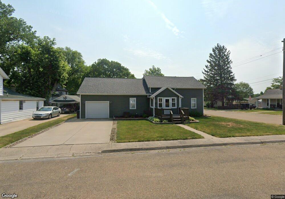
315 S Maple St Lewistown, IL 61542
Estimated Value: $61,000 - $93,000
--
Bed
--
Bath
--
Sq Ft
6,795
Sq Ft Lot
About This Home
This home is located at 315 S Maple St, Lewistown, IL 61542 and is currently estimated at $82,012. 315 S Maple St is a home with nearby schools including Central Elementary School, Lewistown Elementary School, and Lewistown Junior/Senior High School.
Ownership History
Date
Name
Owned For
Owner Type
Purchase Details
Closed on
Jun 27, 2016
Sold by
Shawgo Frank D and Shawgo Rose M
Bought by
Blemler Jeremy M and Blemler Kathey S
Current Estimated Value
Home Financials for this Owner
Home Financials are based on the most recent Mortgage that was taken out on this home.
Original Mortgage
$60,900
Outstanding Balance
$28,027
Interest Rate
3.95%
Mortgage Type
New Conventional
Estimated Equity
$53,985
Create a Home Valuation Report for This Property
The Home Valuation Report is an in-depth analysis detailing your home's value as well as a comparison with similar homes in the area
Home Values in the Area
Average Home Value in this Area
Purchase History
| Date | Buyer | Sale Price | Title Company |
|---|---|---|---|
| Blemler Jeremy M | $61,000 | -- |
Source: Public Records
Mortgage History
| Date | Status | Borrower | Loan Amount |
|---|---|---|---|
| Open | Blemler Jeremy M | $60,900 |
Source: Public Records
Tax History Compared to Growth
Tax History
| Year | Tax Paid | Tax Assessment Tax Assessment Total Assessment is a certain percentage of the fair market value that is determined by local assessors to be the total taxable value of land and additions on the property. | Land | Improvement |
|---|---|---|---|---|
| 2024 | $2,155 | $25,850 | $2,550 | $23,300 |
| 2023 | $2,155 | $24,740 | $2,440 | $22,300 |
| 2022 | $2,232 | $24,740 | $2,440 | $22,300 |
| 2021 | $2,232 | $22,000 | $2,440 | $19,560 |
| 2020 | $2,106 | $21,270 | $2,360 | $18,910 |
| 2019 | $2,154 | $21,610 | $2,400 | $19,210 |
| 2018 | $2,102 | $21,190 | $2,350 | $18,840 |
| 2017 | $2,067 | $21,190 | $2,350 | $18,840 |
| 2016 | $2,046 | $20,460 | $2,270 | $18,190 |
| 2015 | $2,043 | $20,460 | $2,270 | $18,190 |
| 2013 | -- | $19,940 | $2,210 | $17,730 |
| 2012 | -- | $19,460 | $2,160 | $17,300 |
Source: Public Records
Map
Nearby Homes
- 200 W Avenue B
- 111 N Broadway St
- 376 W Euclid Ave
- 704 S Main St
- 101 W Macarthur Ave
- 428 N Main St
- 330 W Avenue G
- 13 Melrose Ln
- 602 E Nimintz Ave
- 1124 S Illinois St
- 1026 N Main St
- 15937 U S 24
- 0 N Highway 9 County Rd Unit RMAPA1260470
- 000 Highway 24
- 1428 N Main St
- 12676 E County 14 Hwy
- 16853 N Wright Rd
- County 14 Lot Unit WP001
- 14953 E Grain Bin Rd
- 10206 E County 14 Hwy
- 307 S Maple St
- 222 E Avenue C
- 209 E Avenue C
- 275 E Avenue B
- 221 E Avenue C
- 121 E Avenue C
- 411 S Maple St
- 415 S Maple St
- 117 E Avenue B
- 117 E Avenue B
- 112 E Avenue C
- 121 E C Ave
- 215 S Maple St
- 220 E Avenue D
- 222 S Illinois St
- 403 S Main St
- 120 E Avenue D
- 317 S Main St
- 221 S Illinois St
- 405 S Illinois St