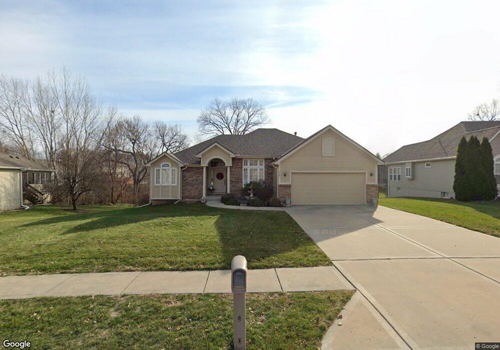
315 Shadowbrook Dr Kearney, MO 64060
Estimated Value: $340,000 - $386,000
1
Bed
3
Baths
1,560
Sq Ft
$230/Sq Ft
Est. Value
About This Home
This home is located at 315 Shadowbrook Dr, Kearney, MO 64060 and is currently estimated at $359,513, approximately $230 per square foot. 315 Shadowbrook Dr is a home located in Clay County with nearby schools including Kearney Junior High School, Kearney High School, and Northern Hills Christian Academy.
Ownership History
Date
Name
Owned For
Owner Type
Purchase Details
Closed on
Jun 27, 2016
Sold by
Doss Keith E
Bought by
Doss Keith E and Doss Janice A
Current Estimated Value
Purchase Details
Closed on
Mar 8, 2005
Sold by
Doss Lois I
Bought by
Doss Lois I and Lois I Doss Revocable Trust
Purchase Details
Closed on
May 5, 2004
Sold by
Couchman Construction Inc
Bought by
Doss Lois I
Create a Home Valuation Report for This Property
The Home Valuation Report is an in-depth analysis detailing your home's value as well as a comparison with similar homes in the area
Home Values in the Area
Average Home Value in this Area
Purchase History
| Date | Buyer | Sale Price | Title Company |
|---|---|---|---|
| Doss Keith E | -- | None Available | |
| Doss Lois I | -- | -- | |
| Doss Lois I | -- | Thomson Title Corp |
Source: Public Records
Tax History Compared to Growth
Tax History
| Year | Tax Paid | Tax Assessment Tax Assessment Total Assessment is a certain percentage of the fair market value that is determined by local assessors to be the total taxable value of land and additions on the property. | Land | Improvement |
|---|---|---|---|---|
| 2025 | $3,751 | $62,890 | -- | -- |
| 2024 | $3,751 | $54,740 | -- | -- |
| 2023 | $3,739 | $54,740 | $0 | $0 |
| 2022 | $3,470 | $49,130 | $0 | $0 |
| 2021 | $3,402 | $49,134 | $5,130 | $44,004 |
| 2020 | $3,436 | $45,140 | $0 | $0 |
| 2019 | $3,418 | $45,144 | $5,130 | $40,014 |
| 2018 | $3,283 | $41,880 | $0 | $0 |
| 2017 | $3,140 | $41,880 | $5,130 | $36,750 |
| 2016 | $3,140 | $40,490 | $5,700 | $34,790 |
| 2015 | $3,141 | $40,490 | $5,700 | $34,790 |
| 2014 | $3,156 | $40,490 | $5,700 | $34,790 |
Source: Public Records
Map
Nearby Homes
- 401 W 11th Terrace
- 324 Regency Park St
- 1701 Park Ln
- 1404 Colony Dr
- 1800 Sunset Dr
- 2001 Foxtail Point
- 401 E 9th St
- 2003 Foxtail Point
- 0 W State Route 92 (Parcel C) N A
- 2007 Foxtail Point
- Redbud Plan at The Meadows At Greenfield - Meadows At Greenfield
- Spruce Plan at The Meadows At Greenfield - Meadows At Greenfield
- Cypress Plan at The Meadows At Greenfield - Meadows At Greenfield
- Monroe Plan at The Meadows At Greenfield - Meadows At Greenfield
- McKinley Plan at The Meadows At Greenfield - Meadows At Greenfield
- Ashton Plan at The Meadows At Greenfield - Meadows At Greenfield
- Meg Plan at The Meadows At Greenfield - Meadows At Greenfield
- The Linden Plan at The Meadows At Greenfield - Meadows At Greenfield
- Sycamore Plan at The Meadows At Greenfield - Meadows At Greenfield
- The Brooklyn Plan at The Meadows At Greenfield - Meadows At Greenfield
- 401 Shadowbrook Dr
- 313 Shadowbrook Dr
- 318 Lee Dr
- 316 Lee Dr
- 400 Lee Dr
- 403 Shadowbrook Dr
- 1300 Regency Dr
- 1302 Regency Dr
- 402 Lee Dr
- 314 Shadowbrook Dr
- 1304 Regency Dr
- 400 Shadowbrook Dr
- 402 Shadowbrook Dr
- 1306 Regency Dr
- 1204 Regency Dr
- 404 Lee Dr
- 405 Shadowbrook Dr
- 1308 Regency Dr
- 404 Shadowbrook Dr
- 1202 Regency Dr