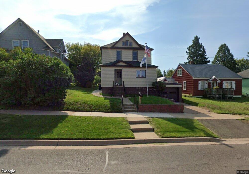
315 W Norrie St Ironwood, MI 49938
Estimated Value: $74,000 - $101,801
3
Beds
1
Bath
1,344
Sq Ft
$62/Sq Ft
Est. Value
About This Home
This home is located at 315 W Norrie St, Ironwood, MI 49938 and is currently estimated at $83,950, approximately $62 per square foot. 315 W Norrie St is a home with nearby schools including Luther L. Wright K-12 School, All Saints Catholic Academy, and Northwoods Christian Academy.
Ownership History
Date
Name
Owned For
Owner Type
Purchase Details
Closed on
Oct 18, 2018
Sold by
Carey Marilyn K and Boggs James
Bought by
Rantanen Bruce
Current Estimated Value
Home Financials for this Owner
Home Financials are based on the most recent Mortgage that was taken out on this home.
Original Mortgage
$34,000
Outstanding Balance
$21,117
Interest Rate
4.5%
Mortgage Type
New Conventional
Estimated Equity
$62,833
Purchase Details
Closed on
May 25, 2016
Sold by
Carey Marilyn K
Bought by
Carey Marilyn K
Purchase Details
Closed on
Oct 6, 2015
Sold by
Parisi Joseph
Bought by
Carey Marilyn K
Create a Home Valuation Report for This Property
The Home Valuation Report is an in-depth analysis detailing your home's value as well as a comparison with similar homes in the area
Home Values in the Area
Average Home Value in this Area
Purchase History
| Date | Buyer | Sale Price | Title Company |
|---|---|---|---|
| Rantanen Bruce | -- | Associated Title & Closing S | |
| Carey Marilyn K | -- | None Available | |
| Carey Marilyn K | -- | None Available |
Source: Public Records
Mortgage History
| Date | Status | Borrower | Loan Amount |
|---|---|---|---|
| Open | Rantanen Bruce | $34,000 |
Source: Public Records
Tax History Compared to Growth
Tax History
| Year | Tax Paid | Tax Assessment Tax Assessment Total Assessment is a certain percentage of the fair market value that is determined by local assessors to be the total taxable value of land and additions on the property. | Land | Improvement |
|---|---|---|---|---|
| 2025 | $1,621 | $38,112 | $38,112 | $0 |
| 2024 | $1,499 | $31,946 | $31,946 | $0 |
| 2023 | $1,535 | $27,848 | $27,848 | $0 |
| 2022 | $1,497 | $23,067 | $23,067 | $0 |
| 2021 | $1,497 | $19,751 | $19,751 | $0 |
| 2020 | -- | -- | $0 | $0 |
| 2019 | -- | -- | $0 | $0 |
| 2018 | -- | -- | $23,539 | $0 |
| 2017 | -- | -- | $0 | $0 |
| 2016 | -- | -- | $0 | $0 |
| 2014 | -- | -- | $0 | $0 |
| 2013 | -- | -- | $0 | $0 |
Source: Public Records
Map
Nearby Homes
- 235 1/2 W Norrie St
- 334 W Ayer St
- 112 W Pewabic St
- 115 E Ayer St
- 400 Silver St
- 615 N Lowell St
- 230 W Michigan Ave
- 202 Copper St
- 126 W Michigan Ave
- ON Oak St
- 509 Poplar St
- 209 E Harding Ave
- 124 Poplar St
- 213 S Mansfield St
- 408 6th Ave N
- 101 S Mansfield St
- 134 S Mansfield St
- 100 W Francis St
- 235 S Curry St
- 119 W Oak St
- 317 W Norrie St
- 325 W Norrie St
- 301 W Norrie St
- 329 W Norrie St
- 316 W Norrie St
- 314 W Norrie St
- 320 W Norrie St
- 308 W Norrie St
- 301 N Albany St
- 202 West St
- 322 W Frederick St
- 304 W Frederick St
- 239 W Norrie St
- 332 W Norrie St Unit 11
- 235 W Norrie St
- 236 W Norrie St
- 235 W Norrie St
- 300 West St
- 300 West St Unit 10
- 332 W Frederick St