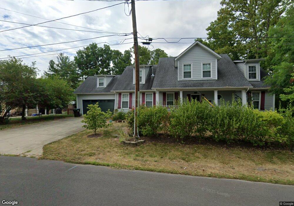
315 W Queen St Strasburg, VA 22657
Estimated Value: $434,000 - $565,000
3
Beds
4
Baths
3,604
Sq Ft
$136/Sq Ft
Est. Value
About This Home
This home is located at 315 W Queen St, Strasburg, VA 22657 and is currently estimated at $491,432, approximately $136 per square foot. 315 W Queen St is a home located in Shenandoah County with nearby schools including Sandy Hook Elementary School, Signal Knob Middle School, and Strasburg High School.
Ownership History
Date
Name
Owned For
Owner Type
Purchase Details
Closed on
May 7, 2010
Sold by
Brown Scott M
Bought by
Rauhala Frans F and Rauhala Erika
Current Estimated Value
Home Financials for this Owner
Home Financials are based on the most recent Mortgage that was taken out on this home.
Original Mortgage
$264,448
Outstanding Balance
$175,679
Interest Rate
4.87%
Mortgage Type
VA
Estimated Equity
$315,753
Create a Home Valuation Report for This Property
The Home Valuation Report is an in-depth analysis detailing your home's value as well as a comparison with similar homes in the area
Home Values in the Area
Average Home Value in this Area
Purchase History
| Date | Buyer | Sale Price | Title Company |
|---|---|---|---|
| Rauhala Frans F | $257,000 | Clear Title Escrow & Settlem |
Source: Public Records
Mortgage History
| Date | Status | Borrower | Loan Amount |
|---|---|---|---|
| Open | Rauhala Frans F | $264,448 |
Source: Public Records
Tax History Compared to Growth
Tax History
| Year | Tax Paid | Tax Assessment Tax Assessment Total Assessment is a certain percentage of the fair market value that is determined by local assessors to be the total taxable value of land and additions on the property. | Land | Improvement |
|---|---|---|---|---|
| 2025 | $2,803 | $438,000 | $62,000 | $376,000 |
| 2024 | $2,803 | $438,000 | $62,000 | $376,000 |
| 2023 | $2,628 | $438,000 | $62,000 | $376,000 |
| 2022 | $2,540 | $438,000 | $62,000 | $376,000 |
| 2021 | $2,067 | $299,500 | $51,000 | $248,500 |
| 2020 | $1,917 | $299,500 | $51,000 | $248,500 |
| 2019 | $1,917 | $299,500 | $51,000 | $248,500 |
| 2018 | $1,917 | $299,500 | $51,000 | $248,500 |
| 2017 | $1,797 | $299,500 | $51,000 | $248,500 |
| 2016 | $1,782 | $297,000 | $51,000 | $246,000 |
| 2015 | -- | $297,000 | $51,000 | $246,000 |
| 2014 | -- | $45,000 | $45,000 | $0 |
Source: Public Records
Map
Nearby Homes
- 291 High St
- 201 Capon St
- 0 W King St Unit VASH2011194
- 444 Branch St
- 0 Beacon Sunset Unit VASH2012084
- 131 S Massanutten St
- 657 Ash St
- 166 Acton Place
- 218 John Marshall Hwy
- 453 Zea St
- 335 Royal Ave
- 588 E King St
- 523 Thompson St
- 373 Walton St
- 0 Pleasant View Dr Unit VASH118442
- 311 Green Acre Dr
- 212 Kanter Dr
- 387 Crim Dr
- 397 Crim Dr
- 176 Virginia St
- 314 W Queen St
- 214 Sharpe St
- 242 Sharpe St
- 308 W Queen St
- 324 W Queen St
- 339 W Queen St
- 174 Sharpe St
- 295 W Queen St
- 219 Sharpe St
- 262 Sharpe St
- 292 W Queen St
- 243 Sharpe St
- 162 Sharpe St
- 279 W Queen St
- 274 Sharpe St
- 352 W Queen St
- 0 Lot A B C Tbd W Queen St Unit VASH122246
- 0 Tbd W Queen St
- 259 Sharpe St
- 348 W Queen St