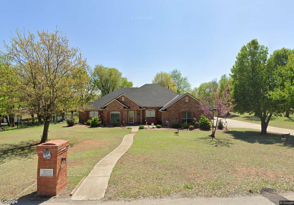
3150 SW 22nd St Newcastle, OK 73065
Estimated Value: $462,000 - $481,000
3
Beds
3
Baths
2,922
Sq Ft
$160/Sq Ft
Est. Value
About This Home
This home is located at 3150 SW 22nd St, Newcastle, OK 73065 and is currently estimated at $467,647, approximately $160 per square foot. 3150 SW 22nd St is a home located in McClain County with nearby schools including Newcastle Elementary School, Newcastle Middle School, and Newcastle High School.
Ownership History
Date
Name
Owned For
Owner Type
Purchase Details
Closed on
Dec 12, 2024
Sold by
Boserman Barbara S and Boserman Robert W
Bought by
Robert And Barbara Boserman Oath Trust and Boserman
Current Estimated Value
Purchase Details
Closed on
Feb 23, 2007
Sold by
Talley George H and Talley Joyce L
Bought by
Boserman Robert W and Boserman Barbara S
Home Financials for this Owner
Home Financials are based on the most recent Mortgage that was taken out on this home.
Original Mortgage
$216,375
Interest Rate
6.17%
Mortgage Type
New Conventional
Create a Home Valuation Report for This Property
The Home Valuation Report is an in-depth analysis detailing your home's value as well as a comparison with similar homes in the area
Home Values in the Area
Average Home Value in this Area
Purchase History
| Date | Buyer | Sale Price | Title Company |
|---|---|---|---|
| Robert And Barbara Boserman Oath Trust | -- | None Listed On Document | |
| Boserman Robert W | $288,500 | Capital Abstract & Title Co |
Source: Public Records
Mortgage History
| Date | Status | Borrower | Loan Amount |
|---|---|---|---|
| Previous Owner | Boserman Robert W | $216,375 |
Source: Public Records
Tax History Compared to Growth
Tax History
| Year | Tax Paid | Tax Assessment Tax Assessment Total Assessment is a certain percentage of the fair market value that is determined by local assessors to be the total taxable value of land and additions on the property. | Land | Improvement |
|---|---|---|---|---|
| 2025 | -- | $35,308 | $4,344 | $30,964 |
| 2024 | $0 | $34,280 | $4,218 | $30,062 |
| 2023 | $0 | $33,281 | $4,014 | $29,267 |
| 2022 | $0 | $32,312 | $3,850 | $28,462 |
| 2021 | $0 | $32,312 | $3,850 | $28,462 |
| 2020 | $0 | $31,776 | $3,850 | $27,926 |
| 2019 | $3,736 | $30,263 | $3,850 | $26,413 |
| 2018 | $3,672 | $30,196 | $3,850 | $26,346 |
| 2017 | $4,151 | $34,209 | $3,850 | $30,359 |
| 2016 | $4,015 | $32,954 | $3,850 | $29,104 |
| 2015 | $3,895 | $31,959 | $3,850 | $28,109 |
| 2014 | $3,825 | $31,797 | $3,850 | $27,947 |
Source: Public Records
Map
Nearby Homes
- 2215 Blackberry Run
- 541 SE 7th Place
- 1049 Dorsi Way
- 689 Pedras Cir
- 8302 Autumn Blaze Dr
- 1409 S Highway 76
- 8001 Autumn Blaze Dr Unit Lot 10
- 8051 Autumn Blaze Dr Unit Lot 11
- 8101 Autumn Blaze Dr Unit Lot 14
- 8101 Autumn Blaze Dr Unit Lot 12
- 1321 Acclivis Ct
- 35168 Homestead Rd
- 2439 Wolf Creek Bend
- 1045 Collis Way
- 1023 Lucas Way
- 1117 Lucas Way
- 905 Lucas Cir
- 1017 Dorsi Way
- 903 Trunci Cir
- Plan 2349+ at Pulchella - Pulchella IV
- 2210 Richland Park
- 2120 Richland Dr
- 2117 S Highway 76
- 2220 S Highway 76
- 2100 Richland Dr
- 2129 S Highway 76
- 2105 S Highway 76
- 2033 S Highway 76
- 3083 SW 21st St
- 2004 S Highway 76
- 2115 Blackberry Run
- 3041 SW 21st St
- 2213 S Highway 76
- 2009 S Highway 76 (Land Only)
- 2995 SW 21st St
- 2210 S Highway 76
- 2166 Blackberry Run
- 2222 Blackberry Run
- 2130 Blackberry Run
- 2949 SW 21st St