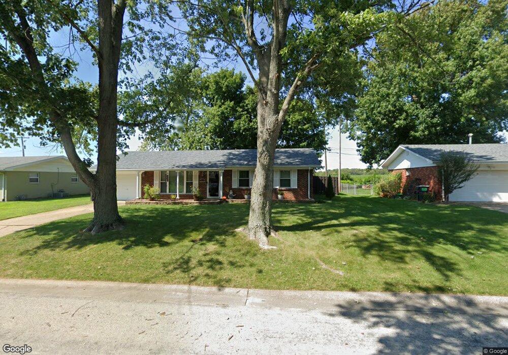
316 Aaron Dr Belleville, IL 62220
Estimated Value: $153,000 - $167,205
3
Beds
2
Baths
1,080
Sq Ft
$147/Sq Ft
Est. Value
About This Home
This home is located at 316 Aaron Dr, Belleville, IL 62220 and is currently estimated at $158,551, approximately $146 per square foot. 316 Aaron Dr is a home located in St. Clair County with nearby schools including Roosevelt Elementary School, Central Jr High School, and Governor French Academy.
Ownership History
Date
Name
Owned For
Owner Type
Purchase Details
Closed on
Oct 15, 2009
Sold by
Kirchoff James J and Krichoff Carol J
Bought by
Faulkner Denise R
Current Estimated Value
Home Financials for this Owner
Home Financials are based on the most recent Mortgage that was taken out on this home.
Original Mortgage
$82,478
Outstanding Balance
$53,391
Interest Rate
5.07%
Mortgage Type
FHA
Estimated Equity
$105,160
Create a Home Valuation Report for This Property
The Home Valuation Report is an in-depth analysis detailing your home's value as well as a comparison with similar homes in the area
Home Values in the Area
Average Home Value in this Area
Purchase History
| Date | Buyer | Sale Price | Title Company |
|---|---|---|---|
| Faulkner Denise R | $84,000 | Freedom Title Llc |
Source: Public Records
Mortgage History
| Date | Status | Borrower | Loan Amount |
|---|---|---|---|
| Open | Faulkner Denise R | $82,478 |
Source: Public Records
Tax History
| Year | Tax Paid | Tax Assessment Tax Assessment Total Assessment is a certain percentage of the fair market value that is determined by local assessors to be the total taxable value of land and additions on the property. | Land | Improvement |
|---|---|---|---|---|
| 2024 | $2,941 | $45,519 | $7,836 | $37,683 |
| 2023 | $2,704 | $40,285 | $7,728 | $32,557 |
| 2022 | $2,482 | $36,689 | $7,038 | $29,651 |
| 2021 | $2,433 | $35,183 | $6,749 | $28,434 |
| 2020 | $2,336 | $32,765 | $6,285 | $26,480 |
| 2019 | $2,296 | $33,144 | $6,415 | $26,729 |
| 2018 | $2,246 | $32,298 | $6,251 | $26,047 |
| 2017 | $2,195 | $31,438 | $6,084 | $25,354 |
| 2016 | $2,199 | $30,354 | $5,874 | $24,480 |
| 2014 | $1,902 | $29,974 | $5,664 | $24,310 |
| 2013 | $2,211 | $29,974 | $5,664 | $24,310 |
Source: Public Records
Map
Nearby Homes
- 130 Dianne Dr
- 49 Dianne Dr
- 1374 Rocky Creek Ct
- 1366 Radden Ct
- 245 Summers Trace
- 218 Winterberry Dr
- 516 Springwood Dr
- 2177 Southern Oak Cir
- 1412 4th Ave
- 1800 Roosevelt Ave
- 1210 3rd Ave
- 1801 Roosevelt Ave
- 807 Gass Ave
- 628 S 19th St
- 1316 Raab Ave
- 817 Union Ave
- 420 State St
- 719 Centreville Ave
- 419 S 8th St
- 34 Lake Forest Dr
Your Personal Tour Guide
Ask me questions while you tour the home.