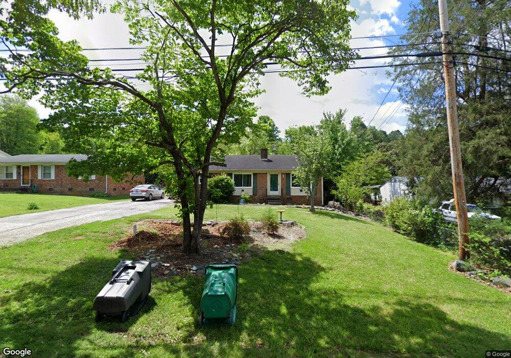
316 Summit Rd High Point, NC 27265
Greater High Point NeighborhoodEstimated Value: $179,000 - $205,000
3
Beds
2
Baths
1,075
Sq Ft
$178/Sq Ft
Est. Value
About This Home
This home is located at 316 Summit Rd, High Point, NC 27265 and is currently estimated at $191,496, approximately $178 per square foot. 316 Summit Rd is a home located in Guilford County with nearby schools including Montlieu Academy of Technology, Welborn Academy of Science & Technology, and T.W. Andrews High School.
Ownership History
Date
Name
Owned For
Owner Type
Purchase Details
Closed on
Sep 15, 2003
Sold by
Stanley Pamela Elaine
Bought by
Paul Christopher and Paul Monica L
Current Estimated Value
Home Financials for this Owner
Home Financials are based on the most recent Mortgage that was taken out on this home.
Original Mortgage
$85,655
Outstanding Balance
$39,435
Interest Rate
6.13%
Mortgage Type
FHA
Estimated Equity
$152,061
Create a Home Valuation Report for This Property
The Home Valuation Report is an in-depth analysis detailing your home's value as well as a comparison with similar homes in the area
Home Values in the Area
Average Home Value in this Area
Purchase History
| Date | Buyer | Sale Price | Title Company |
|---|---|---|---|
| Paul Christopher | $87,000 | -- |
Source: Public Records
Mortgage History
| Date | Status | Borrower | Loan Amount |
|---|---|---|---|
| Open | Paul Christopher | $85,655 |
Source: Public Records
Tax History
| Year | Tax Paid | Tax Assessment Tax Assessment Total Assessment is a certain percentage of the fair market value that is determined by local assessors to be the total taxable value of land and additions on the property. | Land | Improvement |
|---|---|---|---|---|
| 2025 | $1,474 | $107,000 | $24,000 | $83,000 |
| 2024 | $1,474 | $107,000 | $24,000 | $83,000 |
| 2023 | $1,474 | $107,000 | $24,000 | $83,000 |
| 2022 | $1,442 | $107,000 | $24,000 | $83,000 |
| 2021 | $1,204 | $87,400 | $15,000 | $72,400 |
| 2020 | $1,204 | $87,400 | $15,000 | $72,400 |
| 2019 | $1,204 | $87,400 | $0 | $0 |
| 2018 | $1,198 | $87,400 | $0 | $0 |
| 2017 | $1,204 | $87,400 | $0 | $0 |
| 2016 | $1,014 | $72,300 | $0 | $0 |
| 2015 | $1,019 | $72,300 | $0 | $0 |
| 2014 | $1,037 | $72,300 | $0 | $0 |
Source: Public Records
Map
Nearby Homes
- 2373 Dukes Hollow Ct
- 3226 Derby Cir
- 423 Dogwood Cir
- 2462 Dukes Hollow Ct
- 2507 Suffolk Ave
- 1227 Greensboro Rd
- 3100 Stratford Ct
- 1711 Hanover Ct
- 2700 Edenridge Dr
- 1717 Carolina St
- 2507 E Lexington Ave
- 2007 Carlisle Way
- 2706 Edenridge Dr
- 2674 Splitbrooke Dr
- 2511 Copperleaf Ct
- 2005 Carlisle Way
- 1402 Darden St
- 2606 Wexford Place
- 122 Orville Dr
- 1456 London Dr
Your Personal Tour Guide
Ask me questions while you tour the home.