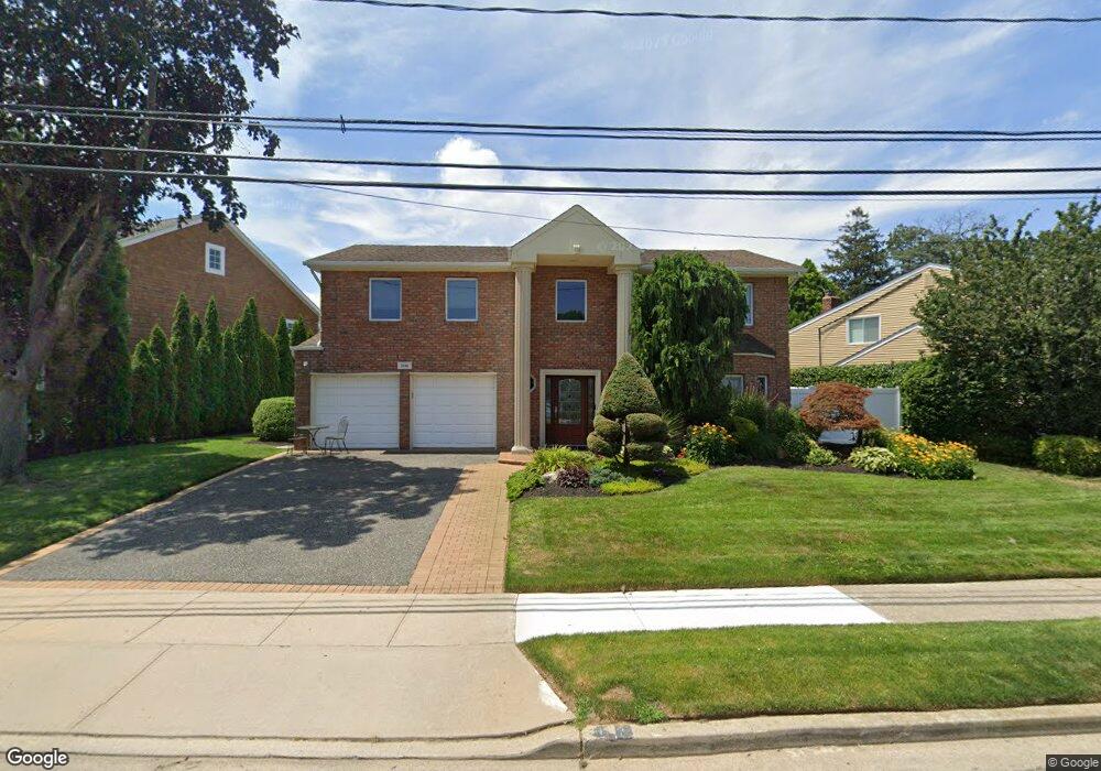
3164 Wynsum Ave Merrick, NY 11566
Estimated Value: $1,098,149 - $1,227,000
Studio
3
Baths
2,747
Sq Ft
$423/Sq Ft
Est. Value
About This Home
This home is located at 3164 Wynsum Ave, Merrick, NY 11566 and is currently estimated at $1,162,575, approximately $423 per square foot. 3164 Wynsum Ave is a home located in Nassau County with nearby schools including Merrick Avenue Middle School, John F. Kennedy High School, and St. Elizabeth Ann Seton Regional School.
Ownership History
Date
Name
Owned For
Owner Type
Purchase Details
Closed on
Jul 26, 2019
Sold by
Bornstein Kenneth and Bornstein Edna
Bought by
Forman Daniel and Forman Alexa
Current Estimated Value
Home Financials for this Owner
Home Financials are based on the most recent Mortgage that was taken out on this home.
Original Mortgage
$606,000
Interest Rate
3.73%
Mortgage Type
New Conventional
Purchase Details
Closed on
Jun 20, 2000
Sold by
Feit Scott and Feit Carrie
Bought by
Bornstein Kenneth and Bornstein Edna
Purchase Details
Closed on
May 3, 1996
Sold by
Kane Stephanie
Bought by
Feit Scott and Feit Carrie
Home Financials for this Owner
Home Financials are based on the most recent Mortgage that was taken out on this home.
Original Mortgage
$286,800
Interest Rate
7.77%
Create a Home Valuation Report for This Property
The Home Valuation Report is an in-depth analysis detailing your home's value as well as a comparison with similar homes in the area
Home Values in the Area
Average Home Value in this Area
Purchase History
| Date | Buyer | Sale Price | Title Company |
|---|---|---|---|
| Forman Daniel | $820,000 | None Available | |
| Bornstein Kenneth | $495,000 | Donald Smith | |
| Feit Scott | $382,500 | -- |
Source: Public Records
Mortgage History
| Date | Status | Borrower | Loan Amount |
|---|---|---|---|
| Previous Owner | Forman Daniel | $606,000 | |
| Previous Owner | Feit Scott | $286,800 |
Source: Public Records
Tax History
| Year | Tax Paid | Tax Assessment Tax Assessment Total Assessment is a certain percentage of the fair market value that is determined by local assessors to be the total taxable value of land and additions on the property. | Land | Improvement |
|---|---|---|---|---|
| 2025 | $21,856 | $720 | $293 | $427 |
| 2024 | $4,802 | $710 | $289 | $421 |
Source: Public Records
Map
Nearby Homes
- 2074 Ellen Dr
- 3311 Hewlett Ave
- 2876 Shore Rd
- 2858 Shore Rd
- 3142 Shore Rd
- 2988 Lee Place
- 2066 Holland Way
- 3058 Susan Rd
- 2884 Bay Dr
- 2845 Whaleneck Dr
- 2070 Beverly Way
- 3200 Lydia Ln
- 2863 Harbor Rd
- 2829 Frankel Blvd
- 2072 Brighton Way
- 1981 Cynthia Ln
- 1993 Lowell Ln
- 2794 Lincoln Blvd
- 2631 Rachel St
- 110 Hampton Way
- 3170 Wynsum Ave
- 3156 Wynsum Ave
- 2100 Vine Dr
- 3176 Wynsum Ave
- 3148 Wynsum Ave
- 2104 Vine Dr
- 2096 Vine Dr
- 3163 Wynsum Ave
- 3167 Wynsum Ave
- 3218 Leeward Ln
- 3171 Wynsum Ave
- 3182 Wynsum Ave
- 3142 Wynsum Ave
- 2110 Vine Dr
- 3177 Wynsum Ave
- 3217 Leeward Ln
- 3236 Leeward Ln
- 3188 Wynsum Ave
- 3136 Wynsum Ave
- 3183 Wynsum Ave
Your Personal Tour Guide
Ask me questions while you tour the home.