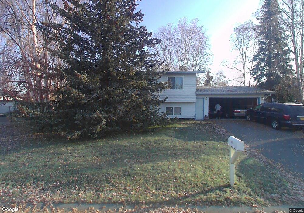
3165 Campbell Airstrip Rd Anchorage, AK 99504
University Area NeighborhoodEstimated Value: $177,000 - $453,000
4
Beds
2
Baths
1,028
Sq Ft
$331/Sq Ft
Est. Value
About This Home
This home is located at 3165 Campbell Airstrip Rd, Anchorage, AK 99504 and is currently estimated at $340,174, approximately $330 per square foot. 3165 Campbell Airstrip Rd is a home located in Anchorage Municipality with nearby schools including Baxter Elementary School, Wendler Middle School, and Bettye Davis East Anchorage High School.
Ownership History
Date
Name
Owned For
Owner Type
Purchase Details
Closed on
Apr 1, 2024
Sold by
Hunt Hannelore E
Bought by
Hunt Katherine Rita
Current Estimated Value
Purchase Details
Closed on
Jan 16, 2024
Sold by
Hunt Ollen Erich
Bought by
Hunt Katherine Rita
Purchase Details
Closed on
Jun 17, 2015
Sold by
Hunt Ollen and Hunt Hannelore E
Bought by
Hunt Hannelore E
Create a Home Valuation Report for This Property
The Home Valuation Report is an in-depth analysis detailing your home's value as well as a comparison with similar homes in the area
Home Values in the Area
Average Home Value in this Area
Purchase History
| Date | Buyer | Sale Price | Title Company |
|---|---|---|---|
| Hunt Katherine Rita | -- | None Listed On Document | |
| Hunt Katherine Rita | -- | None Listed On Document | |
| Hunt Hannelore E | -- | None Available |
Source: Public Records
Tax History Compared to Growth
Tax History
| Year | Tax Paid | Tax Assessment Tax Assessment Total Assessment is a certain percentage of the fair market value that is determined by local assessors to be the total taxable value of land and additions on the property. | Land | Improvement |
|---|---|---|---|---|
| 2025 | $2,142 | $387,400 | $91,200 | $296,200 |
| 2024 | $2,142 | $357,700 | $91,200 | $266,500 |
| 2023 | $5,637 | $331,000 | $91,200 | $239,800 |
| 2022 | $4,639 | $325,500 | $91,200 | $234,300 |
| 2021 | $5,395 | $299,400 | $91,200 | $208,200 |
| 2020 | $4,107 | $291,900 | $91,200 | $200,700 |
| 2019 | $1,458 | $289,100 | $91,200 | $197,900 |
| 2018 | $1,601 | $297,600 | $91,200 | $206,400 |
| 2017 | $1,932 | $293,400 | $91,200 | $202,200 |
| 2016 | $1,520 | $287,900 | $88,900 | $199,000 |
| 2015 | $1,520 | $281,900 | $88,900 | $193,000 |
| 2014 | $1,520 | $281,300 | $82,100 | $199,200 |
Source: Public Records
Map
Nearby Homes
- 5875 Kennyhill Dr
- L1 Whisper Hill Cir
- 6110 Country Lane Cir
- 3209 Eastgate Place Unit 104
- 2731 Lee St
- Slm L1 B1
- 6469 Village Pkwy Unit 203
- 3651 Mirage Cir
- 6030 Glenkerry Dr
- 000 Delwood Place
- 3213 Tayshee Cir
- 3668 Little Bear Place Unit 6
- 3973 Defiance St
- 5554 Sapphire Loop Unit 50B
- 4109 Mclean Place
- 5632 E 40th Ave Unit E201
- 6307 Regent Dr
- 4100 Mclean Place
- 4170 Defiance St
- 6124 E 21st Ave
- 3181 Prescot Cir
- 3153 Campbell Airstrip Rd
- 3171 Ambergate Dr
- 3189 Prescot Cir
- 3166 Campbell Airstrip Rd
- 3176 Prescot Cir
- 3159 Ambergate Dr
- 3154 Campbell Airstrip Rd
- 3176 Campbell Airstrip Rd
- 3190 Prescot Cir
- 3206 Campbell Airstrip Rd
- 3144 Campbell Airstrip Rd
- 3173 Donington Dr
- 3182 Prescot Cir
- 3167 Donington Dr
- 3149 Ambergate Dr
- 3131 Campbell Airstrip Rd
- 3100 Glenn Don Dr
- 3136 Campbell Airstrip Rd
- 3172 Ambergate Dr