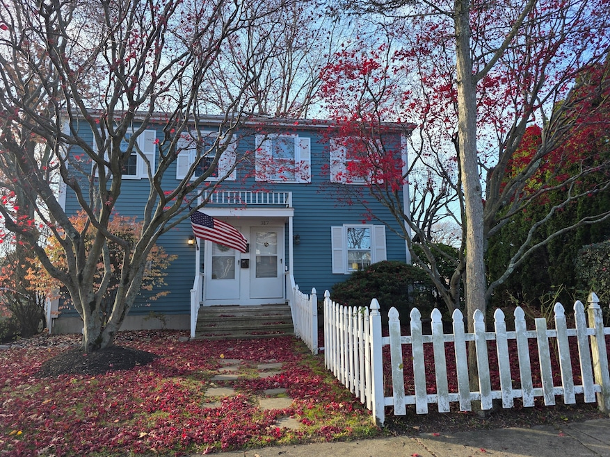
317 Brewster St Bridgeport, CT 06605
Black Rock NeighborhoodEstimated payment $2,265/month
Highlights
- Colonial Architecture
- Porch
- Hot Water Circulator
- Attic
- Home Security System
- 2-minute walk to Ellsworth Park
About This Home
Right in the heart of Black Rock! FANTASTIC LOCATION! Imagine daily breakfast at Harborview market, taking in the view at St. Mary's by the Sea anytime you want, and living your best life in this vibrant community! Yes, this three bedroom, 1.5 bath home with full unfinished basement does need cosmetics and there is work to do, but we have taken that into account and priced the home to attract immediate attention. Fencing and tall arborvitaes ensure privacy. Large eat in kitchen, main level laundry, lots of storage and ample closet space. Make it your own haven, or remodel and rent. Either way, 317 Brewster is one of the best ( if not, THE best investment) that has come along in Black Rock "proper" in a VERY long time! *Professional photos and floor plans coming soon*
Listing Agent
Coldwell Banker Realty Brokerage Phone: (203) 257-5892 License #REB.0375375 Listed on: 12/01/2025

Home Details
Home Type
- Single Family
Est. Annual Taxes
- $6,330
Year Built
- Built in 1982
Lot Details
- 3,920 Sq Ft Lot
- Property is zoned RB
Home Design
- Colonial Architecture
- Concrete Foundation
- Frame Construction
- Asphalt Shingled Roof
- Wood Siding
Interior Spaces
- 1,344 Sq Ft Home
- Concrete Flooring
- Pull Down Stairs to Attic
- Home Security System
Kitchen
- Electric Range
- Microwave
- Dishwasher
Bedrooms and Bathrooms
- 3 Bedrooms
Laundry
- Laundry on main level
- Dryer
- Washer
Unfinished Basement
- Basement Fills Entire Space Under The House
- Interior Basement Entry
- Basement Storage
Parking
- 2 Parking Spaces
- Private Driveway
Outdoor Features
- Porch
Schools
- Black Rock Elementary School
- Bassick High School
Utilities
- Hot Water Heating System
- Heating System Uses Natural Gas
- Hot Water Circulator
- Cable TV Available
Listing and Financial Details
- Assessor Parcel Number 10664
Map
Home Values in the Area
Average Home Value in this Area
Tax History
| Year | Tax Paid | Tax Assessment Tax Assessment Total Assessment is a certain percentage of the fair market value that is determined by local assessors to be the total taxable value of land and additions on the property. | Land | Improvement |
|---|---|---|---|---|
| 2025 | $6,330 | $145,687 | $47,217 | $98,470 |
| 2024 | $6,330 | $145,687 | $47,217 | $98,470 |
| 2023 | $6,330 | $145,687 | $47,217 | $98,470 |
| 2022 | $6,330 | $145,687 | $47,217 | $98,470 |
| 2021 | $6,330 | $145,687 | $47,217 | $98,470 |
| 2020 | $6,644 | $123,060 | $53,400 | $69,660 |
| 2019 | $6,644 | $123,060 | $53,400 | $69,660 |
| 2018 | $6,691 | $123,060 | $53,400 | $69,660 |
| 2017 | $6,691 | $123,060 | $53,400 | $69,660 |
| 2016 | $6,691 | $123,060 | $53,400 | $69,660 |
| 2015 | $5,609 | $132,920 | $42,580 | $90,340 |
| 2014 | $5,609 | $132,920 | $42,580 | $90,340 |
Purchase History
| Date | Type | Sale Price | Title Company |
|---|---|---|---|
| Warranty Deed | $119,000 | -- | |
| Warranty Deed | $119,000 | -- |
Mortgage History
| Date | Status | Loan Amount | Loan Type |
|---|---|---|---|
| Open | $29,200 | No Value Available | |
| Closed | $20,750 | No Value Available | |
| Open | $120,000 | No Value Available |
Source: SmartMLS
MLS Number: 24142409
APN: BRID-000130-000001D
Disclaimer: Certain information contained herein is derived from information provided by parties other than Homes.com. All information provided is deemed reliable, but is not guaranteed to be accurate and should be independently verified.
![]() IDX information is provided exclusively for personal, non-commercial use, and may not be used for any purpose other than to identify prospective properties consumers may be interested in purchasing. Information is deemed reliable but not guaranteed.
IDX information is provided exclusively for personal, non-commercial use, and may not be used for any purpose other than to identify prospective properties consumers may be interested in purchasing. Information is deemed reliable but not guaranteed.
- 75 Homestead Ave Unit 77
- 554 Brewster St Unit 4
- 222 Ellsworth St
- 20 Haddon St Unit 5
- 26 Rowsley St Unit 3
- 37 Rowsley St Unit 6
- 39 Jetland Place Unit 41
- 2773 Fairfield Ave Unit 3
- 51 Princeton St
- 105 Fox St Unit 107
- 165 Bennett St
- 166 Alfred St
- 855 Brewster St Unit 857
- 450 Davidson St
- 167 Scofield Ave
- 82 Waldorf Ave
- 25 Whittier St
- 31 Whittier St
- 135 Whittier St
- 144 Whittier St
- 328 Brewster St
- 96 Seaview Terrace Unit 2ND FLOOR
- 96 Seaview Terrace Unit 2
- 159 Seabright Ave Unit Seabright Ave
- 68 Woodland Ave Unit 3
- 118 Ellsworth St Unit 2nd Floor
- 115 Harborview Ave Unit 1st
- 541 Midland St Unit 545
- 112 Fayerweather Terrace
- 350 Grovers Ave Unit 1C
- 54 School St Unit 1st Fl
- 2979 Fairfield Ave Unit 1R
- 2979 Fairfield Ave Unit R1
- 2806 Fairfield Ave Unit 207
- 2806 Fairfield Ave Unit 101
- 2806 Fairfield Ave Unit 307
- 2886 Fairfield Ave Unit 2
- 2870 Fairfield Ave Unit 2
- 42 Ferris St
- 2679 Fairfield Ave Unit 2