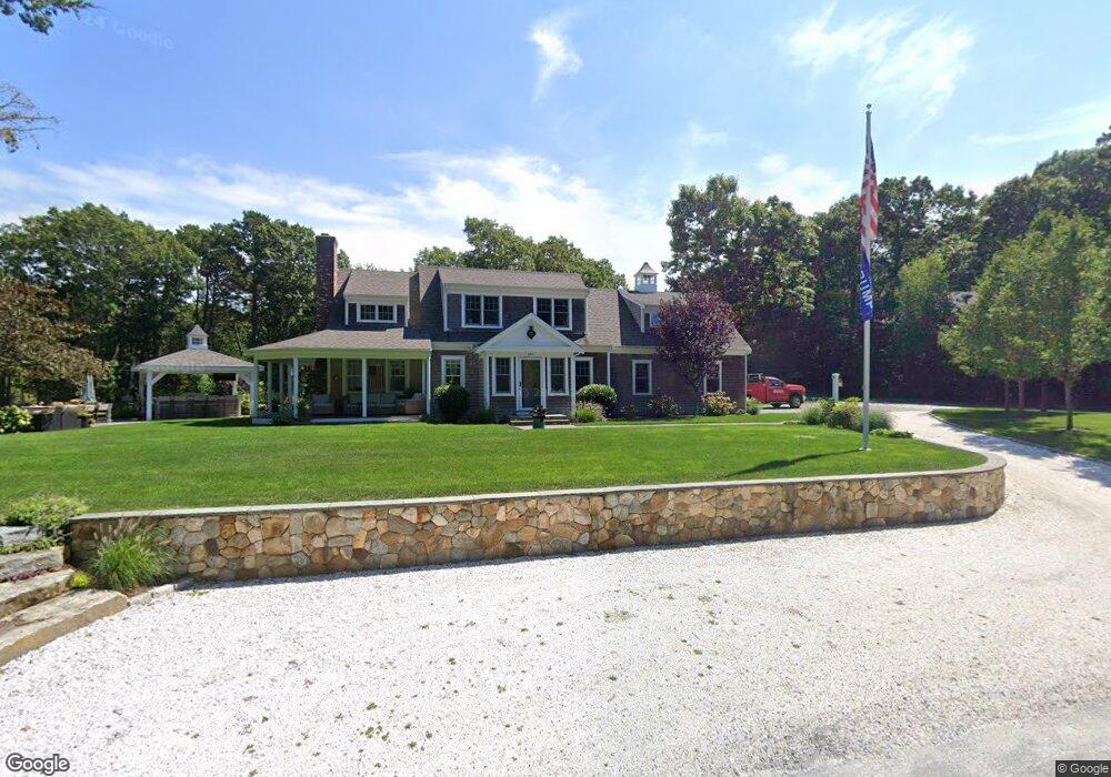
317 Weir Rd Yarmouth Port, MA 2675
Yarmouth Port NeighborhoodEstimated Value: $788,000 - $1,309,000
3
Beds
3
Baths
2,462
Sq Ft
$394/Sq Ft
Est. Value
About This Home
This home is located at 317 Weir Rd, Yarmouth Port, MA 2675 and is currently estimated at $970,905, approximately $394 per square foot. 317 Weir Rd is a home located in Barnstable County with nearby schools including Dennis-Yarmouth Regional High School and St. Pius X. School.
Ownership History
Date
Name
Owned For
Owner Type
Purchase Details
Closed on
Feb 28, 2023
Sold by
Grew Matthew A and Grew Dayton E
Bought by
Dayton E Grew T
Current Estimated Value
Purchase Details
Closed on
Oct 17, 2013
Sold by
Grew Matt A
Bought by
Grew Matthew A and Ricker Dayton E
Home Financials for this Owner
Home Financials are based on the most recent Mortgage that was taken out on this home.
Original Mortgage
$300,000
Interest Rate
3%
Mortgage Type
Adjustable Rate Mortgage/ARM
Create a Home Valuation Report for This Property
The Home Valuation Report is an in-depth analysis detailing your home's value as well as a comparison with similar homes in the area
Home Values in the Area
Average Home Value in this Area
Purchase History
| Date | Buyer | Sale Price | Title Company |
|---|---|---|---|
| Dayton E Grew T | -- | None Available | |
| Grew Matthew A | -- | -- |
Source: Public Records
Mortgage History
| Date | Status | Borrower | Loan Amount |
|---|---|---|---|
| Previous Owner | Grew Matthew A | $300,000 |
Source: Public Records
Tax History Compared to Growth
Tax History
| Year | Tax Paid | Tax Assessment Tax Assessment Total Assessment is a certain percentage of the fair market value that is determined by local assessors to be the total taxable value of land and additions on the property. | Land | Improvement |
|---|---|---|---|---|
| 2025 | $6,077 | $858,300 | $173,500 | $684,800 |
| 2024 | $5,645 | $764,900 | $150,900 | $614,000 |
| 2023 | $5,917 | $729,600 | $137,200 | $592,400 |
| 2022 | $5,340 | $581,700 | $130,900 | $450,800 |
| 2021 | $5,195 | $543,400 | $130,900 | $412,500 |
| 2020 | $5,009 | $500,900 | $138,600 | $362,300 |
| 2019 | $6,051 | $456,600 | $138,600 | $318,000 |
| 2018 | $4,461 | $433,500 | $115,500 | $318,000 |
| 2017 | $4,344 | $433,500 | $115,500 | $318,000 |
| 2016 | $4,234 | $424,200 | $106,200 | $318,000 |
| 2015 | $2,546 | $253,600 | $101,600 | $152,000 |
Source: Public Records
Map
Nearby Homes
- 14 Many Oaks Cir
- 18 Crab Creek Ln
- 8 Rowley Ln
- 16 Warren Rd Unit 16
- 16 Warren Rd
- 800 Route 6a
- 800 Route 6a
- 68 Seminole Dr
- 4 Old Colony Way
- 21 Boxwood Cir
- 20 Trophy Ln
- 6 Nimble Hill Dr
- 118 Driftwood Ln
- 1 Winsome Rd
- 129 Driftwood Ln
- 38 N Dennis Rd
- 32 Deveau Ln
- 4208 Heatherwood
- 176 Beacon St
- 25 Oak Glen
- 7 Bent Bluff Ln
- 310 Weir Rd
- 30 Bent Bluff Ln
- 301 Weir Rd
- 17 Bent Bluff Ln
- 10 Tall Pines Dr
- 352 Weir Rd
- 353 Weir Rd
- 16 Bent Bluff Ln
- 36 Bent Bluff Ln
- 30 Bent Bluff Ln
- 8 Tall Pines Dr
- 21 Bent Bluff Ln
- 12 Tall Pines Dr
- 6 Riseknoll Path
- 362 Weir Rd
- 328 Weir Rd
- 33 Bent Bluff Ln
- 365 Weir Rd
- 6 Tall Pines Dr