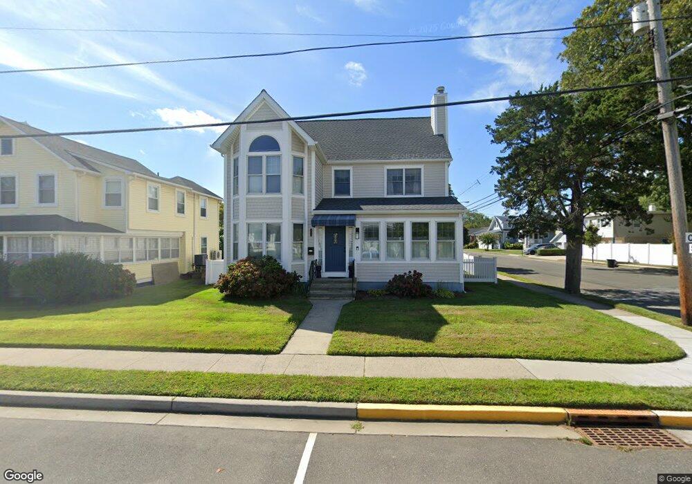
318 Central Ave Point Pleasant Beach, NJ 08742
Point Pleasant Beach NeighborhoodEstimated Value: $1,097,306 - $1,362,000
4
Beds
3
Baths
3,230
Sq Ft
$378/Sq Ft
Est. Value
About This Home
This home is located at 318 Central Ave, Point Pleasant Beach, NJ 08742 and is currently estimated at $1,221,827, approximately $378 per square foot. 318 Central Ave is a home located in Ocean County with nearby schools including G Harold Antrim Elementary School, Point Pleasant Beach High School, and St. Peter School.
Ownership History
Date
Name
Owned For
Owner Type
Purchase Details
Closed on
Feb 23, 2020
Sold by
Maguire Bridget J
Bought by
The Maguire Family Trust
Current Estimated Value
Purchase Details
Closed on
May 21, 2010
Sold by
Kukowski Gary E and Kukowski Leona M
Bought by
Maguire John P and Maguire Bridget J
Home Financials for this Owner
Home Financials are based on the most recent Mortgage that was taken out on this home.
Original Mortgage
$200,000
Interest Rate
4.43%
Mortgage Type
Stand Alone First
Create a Home Valuation Report for This Property
The Home Valuation Report is an in-depth analysis detailing your home's value as well as a comparison with similar homes in the area
Home Values in the Area
Average Home Value in this Area
Purchase History
| Date | Buyer | Sale Price | Title Company |
|---|---|---|---|
| The Maguire Family Trust | -- | None Available | |
| Maguire John P | $572,500 | Advantage Title Agency Inc |
Source: Public Records
Mortgage History
| Date | Status | Borrower | Loan Amount |
|---|---|---|---|
| Closed | Maguire John P | $200,000 |
Source: Public Records
Tax History Compared to Growth
Tax History
| Year | Tax Paid | Tax Assessment Tax Assessment Total Assessment is a certain percentage of the fair market value that is determined by local assessors to be the total taxable value of land and additions on the property. | Land | Improvement |
|---|---|---|---|---|
| 2025 | $8,585 | $499,700 | $326,000 | $173,700 |
| 2024 | $8,325 | $499,700 | $326,000 | $173,700 |
| 2023 | $8,090 | $499,700 | $326,000 | $173,700 |
| 2022 | $8,090 | $499,700 | $326,000 | $173,700 |
| 2021 | $7,910 | $499,700 | $326,000 | $173,700 |
| 2020 | $7,900 | $499,700 | $326,000 | $173,700 |
| 2019 | $7,790 | $499,700 | $326,000 | $173,700 |
| 2018 | $7,670 | $499,700 | $326,000 | $173,700 |
| 2017 | $7,550 | $499,700 | $326,000 | $173,700 |
| 2016 | $7,585 | $499,700 | $326,000 | $173,700 |
| 2015 | $7,525 | $499,700 | $326,000 | $173,700 |
| 2014 | $7,491 | $499,700 | $326,000 | $173,700 |
Source: Public Records
Map
Nearby Homes
- 37 Arnold Ave
- 305 Chicago Ave
- 303 Cooks Ln
- 331 Hawthorne Ave
- 325 Hawthorne Ave Unit 327
- 202 Homestead Ave
- 607 Richmond Ave Unit 4
- 201 Forman Ave
- 110 Trenton Ave
- 503 Atlantic Ave
- 25 Niblick St
- 326 Curtis Ave Unit Lot 27
- 202 Yale Ave
- 728 Arnold Ave
- 328 Curtis Ave Unit Lot 28
- 113 New Jersey Ave
- 109 Griffiths Ave
- 704 Forman Ave
- 118 New York Ave
- 900 Ocean Ave Unit 16
- 316 Central Ave
- 402 Saint Louis Ave
- 314 Central Ave
- 400 Central Ave
- 312 Central Ave
- 319 Central Ave
- 319 Central Ave Unit 2
- 319 Central Ave Unit 1
- 319 Central Ave Unit 2
- 319 Central Ave Unit 1
- 402 Central Ave
- 402 Central Ave
- 317 Central Ave
- 317 Central Ave Unit Back
- 317 Central Ave Unit FRONT
- 401 Central Ave
- 401 Central Ave
- 319 Arnold Ave
- 315 Arnold Ave
- 317 Arnold Ave