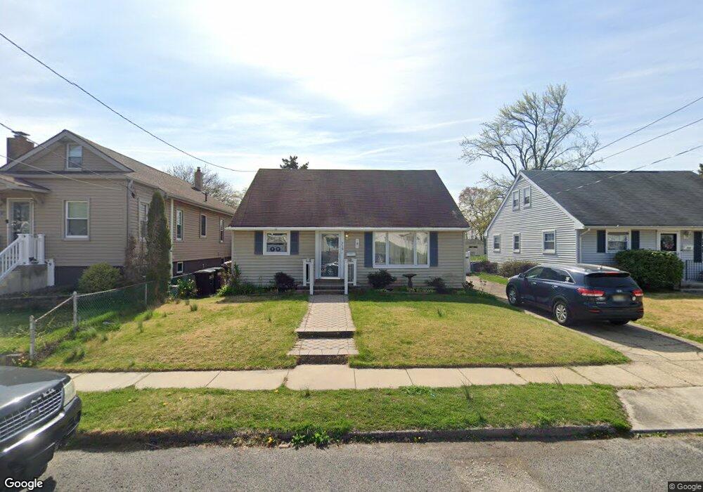
318 County Ave Maple Shade, NJ 08052
Estimated Value: $307,000 - $402,000
4
Beds
2
Baths
1,702
Sq Ft
$215/Sq Ft
Est. Value
About This Home
This home is located at 318 County Ave, Maple Shade, NJ 08052 and is currently estimated at $366,616, approximately $215 per square foot. 318 County Ave is a home located in Burlington County with nearby schools including Maude M. Wilkins Elementary School, Ralph J Steinhauer Elementary School, and Howard R Yocum School.
Ownership History
Date
Name
Owned For
Owner Type
Purchase Details
Closed on
Jan 26, 2026
Sold by
Burlington County Of Sheriff
Bought by
Freddie Mac Seasoned Credit Risk Transfer Tru and Federal Home Loan Mortgage Corporation
Current Estimated Value
Purchase Details
Closed on
Dec 6, 2006
Sold by
Brierton Michael R and Brierton Barbara A
Bought by
Downes Michael and Downes Katherine E
Home Financials for this Owner
Home Financials are based on the most recent Mortgage that was taken out on this home.
Original Mortgage
$161,000
Interest Rate
6.35%
Mortgage Type
Purchase Money Mortgage
Purchase Details
Closed on
Jun 24, 2004
Sold by
Brierton Michael and Brierton Barbara
Bought by
Downes Michael and Downes Katherine
Home Financials for this Owner
Home Financials are based on the most recent Mortgage that was taken out on this home.
Original Mortgage
$121,000
Interest Rate
9%
Mortgage Type
Seller Take Back
Create a Home Valuation Report for This Property
The Home Valuation Report is an in-depth analysis detailing your home's value as well as a comparison with similar homes in the area
Home Values in the Area
Average Home Value in this Area
Purchase History
| Date | Buyer | Sale Price | Title Company |
|---|---|---|---|
| Freddie Mac Seasoned Credit Risk Transfer Tru | $273,000 | None Listed On Document | |
| Downes Michael | $121,000 | Transtar National Title | |
| Downes Michael | $121,000 | Transtar National Title | |
| Downes Michael | $121,000 | Congress Title Corp |
Source: Public Records
Mortgage History
| Date | Status | Borrower | Loan Amount |
|---|---|---|---|
| Previous Owner | Downes Michael | $161,000 | |
| Previous Owner | Downes Michael | $121,000 | |
| Closed | Downes Michael | $0 |
Source: Public Records
Tax History
| Year | Tax Paid | Tax Assessment Tax Assessment Total Assessment is a certain percentage of the fair market value that is determined by local assessors to be the total taxable value of land and additions on the property. | Land | Improvement |
|---|---|---|---|---|
| 2025 | $6,689 | $176,200 | $47,200 | $129,000 |
| 2024 | $6,495 | $176,200 | $47,200 | $129,000 |
| 2023 | $6,495 | $176,200 | $47,200 | $129,000 |
| 2022 | $6,394 | $176,200 | $47,200 | $129,000 |
| 2021 | $6,333 | $176,200 | $47,200 | $129,000 |
| 2020 | $6,350 | $176,200 | $47,200 | $129,000 |
| 2019 | $6,118 | $176,200 | $47,200 | $129,000 |
| 2018 | $6,012 | $176,200 | $47,200 | $129,000 |
| 2017 | $5,941 | $176,200 | $47,200 | $129,000 |
| 2016 | $5,853 | $176,200 | $47,200 | $129,000 |
| 2015 | $5,727 | $176,200 | $47,200 | $129,000 |
| 2014 | $5,552 | $176,200 | $47,200 | $129,000 |
Source: Public Records
Map
Nearby Homes
- 226 Ruth Ave
- 223 Ruth Ave
- 109 E Mill Rd
- 115 S Walnut Ave
- 44 S Pine Ave
- 15 S Pine Ave
- 115 E Kings Hwy Unit 243
- 115 E Kings Hwy Unit 187
- 115 E Kings Hwy Unit 271
- 115 E Kings Hwy Unit 186
- 115 E Kings Hwy Unit 360
- 115 E Kings Hwy Unit 125
- 106 W Mill Rd
- 42 Spruce Ave
- 61 S Maple Ave
- 427 Cutler Ave
- 66 W Center Ave
- 26 Morris Ave
- 48 Helen Ave
- 114 Weather Vane Dr
Your Personal Tour Guide
Ask me questions while you tour the home.