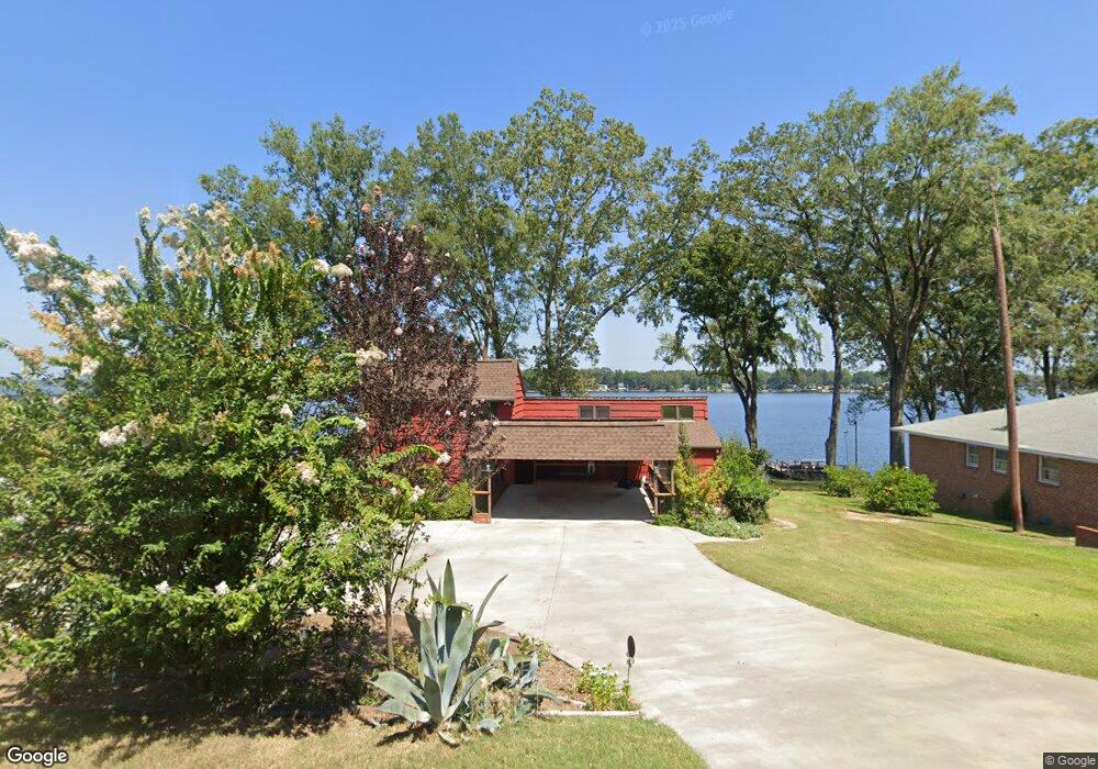
318 Port Royal Dr Ninety Six, SC 29666
Estimated Value: $467,000 - $630,000
3
Beds
2
Baths
1,913
Sq Ft
$272/Sq Ft
Est. Value
About This Home
This home is located at 318 Port Royal Dr, Ninety Six, SC 29666 and is currently estimated at $520,953, approximately $272 per square foot. 318 Port Royal Dr is a home with nearby schools including Ninety Six Primary School, Ninety Six Elementary School, and Edgewood Middle School.
Ownership History
Date
Name
Owned For
Owner Type
Purchase Details
Closed on
Jun 26, 2025
Sold by
Blair Branson T
Bought by
Blair Branson T and Blair Maja D
Current Estimated Value
Home Financials for this Owner
Home Financials are based on the most recent Mortgage that was taken out on this home.
Original Mortgage
$500,500
Outstanding Balance
$499,646
Interest Rate
6.81%
Mortgage Type
New Conventional
Estimated Equity
$21,307
Purchase Details
Closed on
Feb 27, 2025
Sold by
Blair Joseph Grant
Bought by
Blair Branson T
Purchase Details
Closed on
Apr 27, 2012
Sold by
Blair Joseph Grant and Blair Cora K
Bought by
Blair Joseph Grant and Blair Cora K
Create a Home Valuation Report for This Property
The Home Valuation Report is an in-depth analysis detailing your home's value as well as a comparison with similar homes in the area
Home Values in the Area
Average Home Value in this Area
Purchase History
| Date | Buyer | Sale Price | Title Company |
|---|---|---|---|
| Blair Branson T | -- | None Listed On Document | |
| Blair Branson T | -- | None Listed On Document | |
| Blair Branson T | $4,054 | None Listed On Document | |
| Blair Branson T | $4,054 | None Listed On Document | |
| Blair Joseph Grant | -- | -- |
Source: Public Records
Mortgage History
| Date | Status | Borrower | Loan Amount |
|---|---|---|---|
| Open | Blair Branson T | $500,500 | |
| Closed | Blair Branson T | $500,500 |
Source: Public Records
Tax History Compared to Growth
Tax History
| Year | Tax Paid | Tax Assessment Tax Assessment Total Assessment is a certain percentage of the fair market value that is determined by local assessors to be the total taxable value of land and additions on the property. | Land | Improvement |
|---|---|---|---|---|
| 2024 | $1,213 | $10,020 | $0 | $0 |
| 2023 | $1,213 | $10,020 | $0 | $0 |
| 2022 | $1,202 | $10,020 | $0 | $0 |
| 2021 | $1,189 | $10,020 | $0 | $0 |
| 2020 | $1,020 | $8,710 | $0 | $0 |
| 2019 | $1,017 | $8,710 | $0 | $0 |
| 2018 | $1,006 | $217,700 | $76,000 | $141,700 |
| 2017 | $0 | $217,700 | $76,000 | $141,700 |
| 2016 | $994 | $217,700 | $76,000 | $141,700 |
| 2015 | $842 | $189,300 | $66,100 | $123,200 |
| 2014 | $827 | $7,570 | $0 | $0 |
| 2010 | -- | $164,600 | $57,500 | $107,100 |
Source: Public Records
Map
Nearby Homes
- 104 Bayview Dr
- 1734 Pineland Shores Cir
- 102 P C Jean Rd
- 00 Pineland Shores Cir
- 334 Pelican Harbor Dr
- 219 Nautical Way
- 681 Amber Hill Cir
- 712 State Road S-30-566
- 463 Cane Creek Camp Park
- 463 Cane Creek Camp Lot 41 Rd
- 862 State Road S-30-286
- 0 Osprey Cir Unit 1546660
- 0 Osprey Cir Unit 22500021
- 0 Osprey Cir Unit 22499942
- 220 Gardenia Dr
- 242 Gardenia Dr
- 132 Sassafrass
- 130 Sassafrass
- 128 Gardenia Dr
- 00 Hidden Springs Way
- 314 Port Royal Dr
- 322 Port Royal Dr
- 324 Port Royal Dr
- 325 Port Royal Dr
- 409 Port Royal Dr
- 326 Port Royal Dr
- 310 Port Royal Dr
- 402 Port Royal Dr
- 404 Port Royal Dr
- 406 Port Royal Dr
- 104 Cape Hatteras Ct
- 309 Port Royal Dr
- 303 Port Royal Dr
- 102 Surfside Cir
- 104 Surfside Cir
- 301 Port Royal Dr
- 220 Port Royal Dr
- 106 Surfside Cir
- 218 Port Royal Dr
- 101 Gulf Port Dr