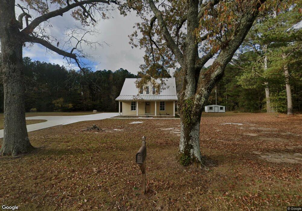
318 Stovall Rd Lagrange, GA 30241
Estimated Value: $234,000 - $366,000
2
Beds
2
Baths
2,083
Sq Ft
$149/Sq Ft
Est. Value
About This Home
This home is located at 318 Stovall Rd, Lagrange, GA 30241 and is currently estimated at $310,363, approximately $148 per square foot. 318 Stovall Rd is a home located in Troup County with nearby schools including Rosemont Elementary School, Whitesville Road Elementary School, and Berta Weathersbee Elementary School.
Ownership History
Date
Name
Owned For
Owner Type
Purchase Details
Closed on
Mar 3, 2015
Sold by
Lan Susan F
Bought by
Murphy David E
Current Estimated Value
Purchase Details
Closed on
Dec 16, 2004
Sold by
Alfred R Langford
Bought by
Langford Susan F
Purchase Details
Closed on
Sep 30, 1985
Sold by
Langsford Alfred R
Bought by
Alfred R Langford
Purchase Details
Closed on
Jun 1, 1960
Sold by
Reiger Annie L
Bought by
Langsford Alfred R
Create a Home Valuation Report for This Property
The Home Valuation Report is an in-depth analysis detailing your home's value as well as a comparison with similar homes in the area
Purchase History
| Date | Buyer | Sale Price | Title Company |
|---|---|---|---|
| Murphy David E | $200,000 | -- | |
| Langford Susan F | -- | -- | |
| Langford Susan F | -- | -- | |
| Alfred R Langford | -- | -- | |
| Langsford Alfred R | -- | -- |
Source: Public Records
Tax History
| Year | Tax Paid | Tax Assessment Tax Assessment Total Assessment is a certain percentage of the fair market value that is determined by local assessors to be the total taxable value of land and additions on the property. | Land | Improvement |
|---|---|---|---|---|
| 2025 | $1,700 | $93,720 | $45,240 | $48,480 |
| 2024 | $1,525 | $87,560 | $45,240 | $42,320 |
| 2023 | $1,527 | $87,880 | $45,240 | $42,640 |
| 2022 | $1,387 | $79,320 | $42,440 | $36,880 |
| 2021 | $1,329 | $80,080 | $47,800 | $32,280 |
| 2020 | $1,322 | $80,080 | $47,800 | $32,280 |
| 2019 | $1,308 | $79,840 | $47,800 | $32,040 |
| 2018 | $1,213 | $76,920 | $47,800 | $29,120 |
| 2017 | $1,207 | $76,920 | $47,800 | $29,120 |
| 2016 | $1,175 | $76,056 | $47,824 | $28,232 |
| 2015 | $1,850 | $63,220 | $38,375 | $24,846 |
| 2014 | $927 | $63,132 | $38,375 | $24,757 |
| 2013 | -- | $76,422 | $51,664 | $24,757 |
Source: Public Records
Map
Nearby Homes
- 37.23 ACRES / 0 Smokey Rd
- 158 S Glenn Rd
- 0 Briley Rd Unit 10582531
- 0 Briley Rd Unit 214353
- 0 Smokey Rd Unit 10570471
- 0 Lower Big Springs Rd Unit 10718109
- 0 Lower Big Springs Rd Unit 26695797
- 829 Thrash Rd
- 950 John Lovelace Rd
- 5656 Hamilton Rd
- 5656 Hamilton Rd
- 830 John Lovelace Rd
- 23 Nantucket Dr
- 53 Nantucket Dr
- 476 Thrash Rd
- 123 Wexford Dr
- 201 & 203 Alton Dr
- 137 Robertson Rd
- 2477 Upper Big Springs Rd
- 111 Prestwick Dr
- 297 Stovall Rd
- 248 Stovall Rd
- 269 Stovall Rd
- 379 Stovall Rd
- 184 Stovall Rd
- 484 Stovall Rd
- 87 Stovall Rd
- 1005 Smokey Rd
- 571 Stovall Rd
- 2516 Lower Big Springs Rd
- 1089 Smokey Rd
- 2546 Lower Big Springs Rd
- 2594 Lower Big Springs Rd
- 1157 Smokey Rd
- 1139 Smokey Rd
- 2576 Lower Big Springs Rd
- 2560 Lower Big Springs Rd
- 648 Stovall Rd
- 1050 Smokey Rd
- 273 Stovall Rd
Your Personal Tour Guide
Ask me questions while you tour the home.