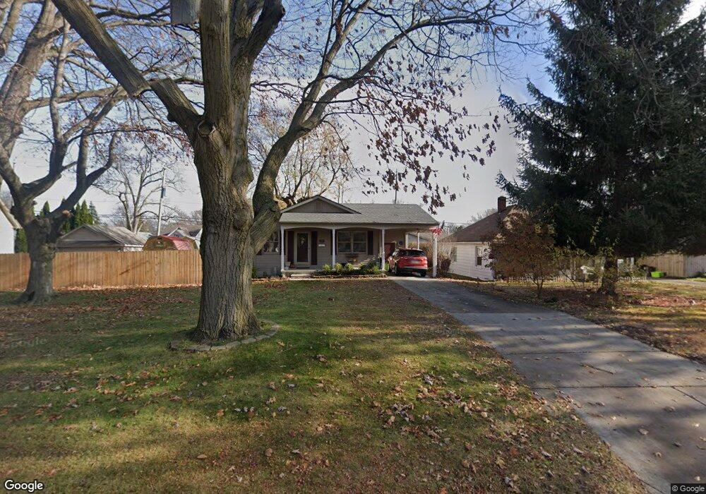
3180 10th Ave Port Huron, MI 48060
Estimated Value: $196,000 - $206,000
3
Beds
2
Baths
1,066
Sq Ft
$188/Sq Ft
Est. Value
About This Home
This home is located at 3180 10th Ave, Port Huron, MI 48060 and is currently estimated at $200,211, approximately $187 per square foot. 3180 10th Ave is a home located in St. Clair County with nearby schools including Garfield Elementary School, Holland Woods Middle School, and Port Huron Northern High School.
Ownership History
Date
Name
Owned For
Owner Type
Purchase Details
Closed on
Aug 11, 2022
Sold by
Jean Wickmiller Barbara
Bought by
Wickmiller Barbara Jean
Current Estimated Value
Purchase Details
Closed on
Mar 9, 2022
Sold by
Jean Wickmiller Barbara
Bought by
Wickmiller Barbara Jean
Purchase Details
Closed on
Feb 22, 2006
Sold by
Secretary Of Housing & Urban Development
Bought by
Wickmiller Gary E and Wickmiller Barbara J
Purchase Details
Closed on
Sep 14, 2005
Sold by
Chase Manhattan Mortgage
Bought by
Secretary Of Housing & Urban Development
Create a Home Valuation Report for This Property
The Home Valuation Report is an in-depth analysis detailing your home's value as well as a comparison with similar homes in the area
Home Values in the Area
Average Home Value in this Area
Purchase History
| Date | Buyer | Sale Price | Title Company |
|---|---|---|---|
| Wickmiller Barbara Jean | -- | Touma Watson Whaling Coury Str | |
| Wickmiller Barbara Jean | -- | None Listed On Document | |
| Wickmiller Gary E | $100,000 | Wolverton Title Research Co | |
| Secretary Of Housing & Urban Development | -- | None Available |
Source: Public Records
Tax History Compared to Growth
Tax History
| Year | Tax Paid | Tax Assessment Tax Assessment Total Assessment is a certain percentage of the fair market value that is determined by local assessors to be the total taxable value of land and additions on the property. | Land | Improvement |
|---|---|---|---|---|
| 2025 | $2,311 | $94,600 | $0 | $0 |
| 2024 | $1,970 | $85,800 | $0 | $0 |
| 2023 | $1,861 | $76,300 | $0 | $0 |
| 2022 | $1,960 | $64,500 | $0 | $0 |
| 2021 | $1,861 | $60,600 | $0 | $0 |
| 2020 | $1,882 | $58,400 | $58,400 | $0 |
| 2019 | $1,848 | $51,200 | $0 | $0 |
| 2018 | $1,807 | $51,200 | $0 | $0 |
| 2016 | $1,381 | $46,800 | $0 | $0 |
| 2015 | $1,355 | $41,700 | $41,700 | $0 |
| 2014 | $1,355 | $38,200 | $38,200 | $0 |
| 2013 | -- | $37,200 | $0 | $0 |
Source: Public Records
Map
Nearby Homes
- 3214 Poplar St
- 3321 Stone St
- 1020 Sanborn St
- 1202 Palmer Ct
- 1424 Hazelwood Ln
- 2913 11th Ave
- 1531 Robinson St
- 1434 Schumaker St
- 3455 Gratiot Ave
- 1218 Garfield St
- 3208 Mount Vernon Rd
- 2835 17th Ave
- 1116 Hancock St
- 3419 Riverside Dr
- 2812 19th Ave
- 2400 Walnut St
- 2400 Stone St Unit 2414
- 2419 Cherry St
- 909 Elmwood St
- 2431 Armour St