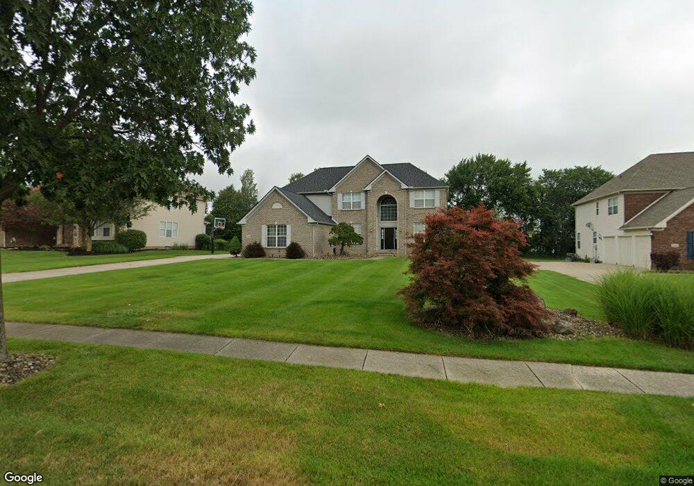
3183 Abrams Dr Twinsburg, OH 44087
Estimated Value: $523,000 - $592,000
4
Beds
3
Baths
2,746
Sq Ft
$205/Sq Ft
Est. Value
About This Home
This home is located at 3183 Abrams Dr, Twinsburg, OH 44087 and is currently estimated at $561,966, approximately $204 per square foot. 3183 Abrams Dr is a home located in Summit County with nearby schools including Wilcox Primary School, Dodge Intermediate School, and Samuel Bissell Elementary School.
Ownership History
Date
Name
Owned For
Owner Type
Purchase Details
Closed on
Feb 26, 2002
Sold by
Kimball Hill Homes Ohio Inc
Bought by
Wilson Tracy L and Wilson Jennifer L
Current Estimated Value
Home Financials for this Owner
Home Financials are based on the most recent Mortgage that was taken out on this home.
Original Mortgage
$210,000
Outstanding Balance
$86,858
Interest Rate
6.92%
Estimated Equity
$475,108
Create a Home Valuation Report for This Property
The Home Valuation Report is an in-depth analysis detailing your home's value as well as a comparison with similar homes in the area
Home Values in the Area
Average Home Value in this Area
Purchase History
| Date | Buyer | Sale Price | Title Company |
|---|---|---|---|
| Wilson Tracy L | $288,100 | Affiliated Title |
Source: Public Records
Mortgage History
| Date | Status | Borrower | Loan Amount |
|---|---|---|---|
| Open | Wilson Tracy L | $210,000 |
Source: Public Records
Tax History Compared to Growth
Tax History
| Year | Tax Paid | Tax Assessment Tax Assessment Total Assessment is a certain percentage of the fair market value that is determined by local assessors to be the total taxable value of land and additions on the property. | Land | Improvement |
|---|---|---|---|---|
| 2025 | $7,963 | $165,474 | $34,969 | $130,505 |
| 2024 | $7,963 | $165,474 | $34,969 | $130,505 |
| 2023 | $7,963 | $165,474 | $34,969 | $130,505 |
| 2022 | $6,422 | $119,046 | $25,158 | $93,888 |
| 2021 | $6,453 | $119,046 | $25,158 | $93,888 |
| 2020 | $6,259 | $119,050 | $25,160 | $93,890 |
| 2019 | $5,889 | $104,700 | $29,180 | $75,520 |
| 2018 | $5,771 | $104,700 | $29,180 | $75,520 |
| 2017 | $5,127 | $104,700 | $29,180 | $75,520 |
| 2016 | $5,096 | $98,600 | $29,180 | $69,420 |
| 2015 | $5,127 | $98,600 | $29,180 | $69,420 |
| 2014 | $5,117 | $98,600 | $29,180 | $69,420 |
| 2013 | $4,995 | $96,330 | $29,180 | $67,150 |
Source: Public Records
Map
Nearby Homes
- 3281 Evans Way
- 2825 Veron Ln
- 2668 Walton Blvd
- 2923 Alling Dr
- 2627 Post Rd
- 2708 Edgebrook Crossing Unit 19
- 3284 Cannon Rd
- 3331 Shale Dr
- 2590 Post Rd
- 2869 Tinkers Ln
- 3320 Blossom Trail
- 3336 Blossom Trail
- 10169 Timothy Ln
- 10358 Townley Ct
- 10265 Beaver Trail
- 10000 Ravenna Rd
- 3624 Nautilus Trail
- 2607 Burridge Cir Unit M29
- 2619 E Aurora Rd
- 10269 Smugglers Cove
- 3173 Abrams Dr
- 3193 Abrams Dr
- 3163 Abrams Dr
- 3180 Abrams Dr
- 3190 Abrams Dr
- 3050 Steffan Woods Dr
- 3048 Steffan Woods Dr
- 3153 Abrams Dr
- 3170 Abrams Dr
- 3038 Steffan Woods Dr
- 3200 Abrams Dr
- 3020 Steffan Woods Dr
- 3028 Steffan Woods Dr
- 3160 Abrams Dr
- 9387 Grace Dr
- 3143 Abrams Dr
- 9620 Liberty Rd
- 3150 Abrams Dr
- 3012 Steffan Woods Dr
- 9380 Grace Dr