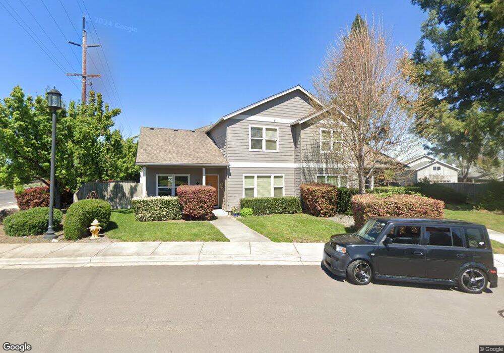
319 Cascade Dr Central Point, OR 97502
Estimated Value: $377,000 - $407,000
3
Beds
2
Baths
1,609
Sq Ft
$242/Sq Ft
Est. Value
About This Home
This home is located at 319 Cascade Dr, Central Point, OR 97502 and is currently estimated at $389,393, approximately $242 per square foot. 319 Cascade Dr is a home located in Jackson County with nearby schools including Jewett Elementary School, Scenic Middle School, and Crater High School.
Ownership History
Date
Name
Owned For
Owner Type
Purchase Details
Closed on
Dec 29, 2020
Sold by
Whitlock Jim R and Whitlock Carmen D
Bought by
Whitlock Family Living Trust and Whitlock
Current Estimated Value
Purchase Details
Closed on
Jun 12, 2005
Sold by
Advanced Homebuilders Inc
Bought by
Whitlock Jim R and Whitlock Carmen D
Create a Home Valuation Report for This Property
The Home Valuation Report is an in-depth analysis detailing your home's value as well as a comparison with similar homes in the area
Purchase History
| Date | Buyer | Sale Price | Title Company |
|---|---|---|---|
| Whitlock Family Living Trust | -- | None Listed On Document | |
| Whitlock Family Living Trust | -- | None Listed On Document | |
| Whitlock Jim R | -- | Lawyers Title Ins |
Source: Public Records
Tax History
| Year | Tax Paid | Tax Assessment Tax Assessment Total Assessment is a certain percentage of the fair market value that is determined by local assessors to be the total taxable value of land and additions on the property. | Land | Improvement |
|---|---|---|---|---|
| 2026 | $3,369 | $203,570 | -- | -- |
| 2025 | $3,286 | $197,650 | $88,310 | $109,340 |
| 2024 | $3,286 | $191,900 | $85,740 | $106,160 |
| 2023 | $3,181 | $186,320 | $83,240 | $103,080 |
| 2022 | $3,106 | $186,320 | $83,240 | $103,080 |
| 2021 | $3,018 | $180,900 | $80,810 | $100,090 |
| 2020 | $2,930 | $175,640 | $78,460 | $97,180 |
| 2019 | $2,858 | $165,570 | $73,960 | $91,610 |
| 2018 | $2,771 | $160,750 | $71,810 | $88,940 |
| 2017 | $2,701 | $160,750 | $71,810 | $88,940 |
| 2016 | $2,622 | $151,530 | $67,680 | $83,850 |
| 2015 | $2,512 | $151,530 | $67,680 | $83,850 |
| 2014 | $2,448 | $142,840 | $63,790 | $79,050 |
Source: Public Records
Map
Nearby Homes
- 388 Brookhaven Dr
- 1160 Boulder Ridge St
- 252 Jena Ct Unit 1
- 356 Marian Ave Unit 40
- 4626 N Pacific Hwy
- 0 Boulder Ridge St
- 650 Golden Peak Dr
- 545 Bridge Creek Dr
- 409 Castle Rock Dr
- 1860 Cottonwood Dr
- 1855 Nancy Ave
- 1501 River Run St
- 1301 River Run St
- 1028 Buck Point St
- 106 Victoria Way
- 659 Blue Moon Dr
- 4065 Crestwood Cir
- 1134 Steamboat Dr
- 0 N 3rd St
- 55 Crater Ln
- 329 Cascade Dr
- 4644 N Pacific Hwy
- 318 Brookhaven Dr
- 308 Brookhaven Dr
- 328 Brookhaven Dr
- 298 Brookhaven Dr Unit L20
- 298 Brookhaven Dr
- 338 Brookhaven Dr
- 388 Cascade Dr
- 359 Cascade Dr
- 348 Brookhaven Dr
- 4618 N Pacific Hwy
- 358 Brookhaven Dr
- 368 Brookhaven Dr
- 379 Cascade Dr
- 317 Brookhaven Dr
- 4682 N Pacific Hwy
- 368 Cascade Dr
- 307 Brookhaven Dr
- 337 Brookhaven Dr
Your Personal Tour Guide
Ask me questions while you tour the home.