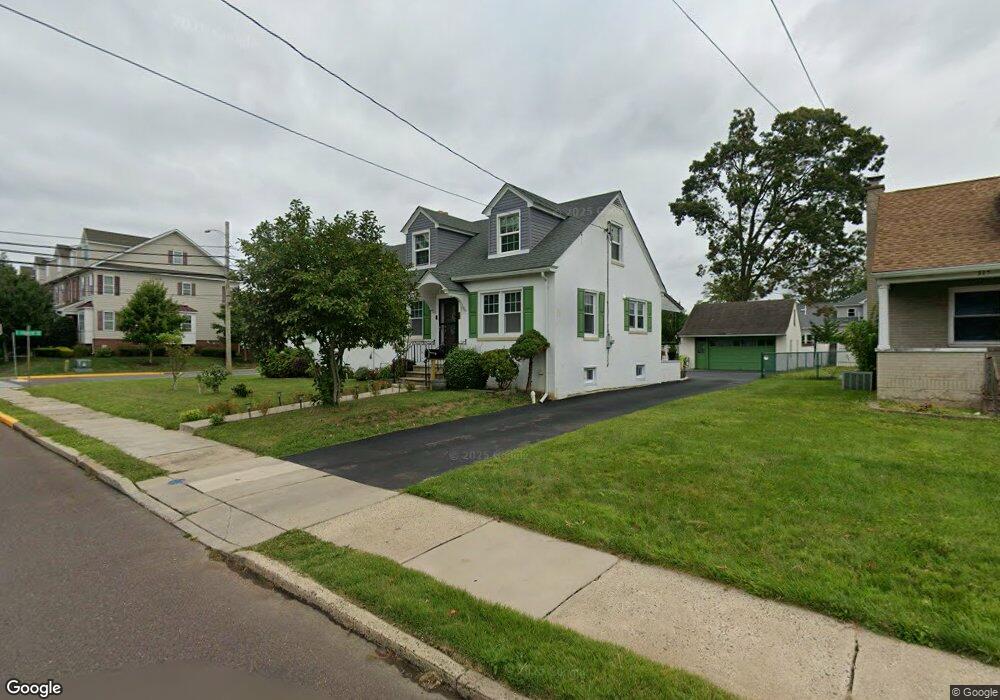
319 N Line St Lansdale, PA 19446
Estimated Value: $369,000 - $494,000
5
Beds
2
Baths
2,205
Sq Ft
$207/Sq Ft
Est. Value
About This Home
This home is located at 319 N Line St, Lansdale, PA 19446 and is currently estimated at $455,874, approximately $206 per square foot. 319 N Line St is a home located in Montgomery County with nearby schools including Knapp Elementary School, Penndale Middle School, and North Penn Senior High School.
Ownership History
Date
Name
Owned For
Owner Type
Purchase Details
Closed on
Apr 23, 2010
Sold by
Buckwalter Joann L and Dziedzic John W
Bought by
Saha Ratan and Saha Tandra
Current Estimated Value
Home Financials for this Owner
Home Financials are based on the most recent Mortgage that was taken out on this home.
Original Mortgage
$172,000
Outstanding Balance
$114,728
Interest Rate
5.03%
Estimated Equity
$341,146
Create a Home Valuation Report for This Property
The Home Valuation Report is an in-depth analysis detailing your home's value as well as a comparison with similar homes in the area
Home Values in the Area
Average Home Value in this Area
Purchase History
| Date | Buyer | Sale Price | Title Company |
|---|---|---|---|
| Saha Ratan | $215,000 | None Available |
Source: Public Records
Mortgage History
| Date | Status | Borrower | Loan Amount |
|---|---|---|---|
| Open | Saha Ratan | $172,000 |
Source: Public Records
Tax History Compared to Growth
Tax History
| Year | Tax Paid | Tax Assessment Tax Assessment Total Assessment is a certain percentage of the fair market value that is determined by local assessors to be the total taxable value of land and additions on the property. | Land | Improvement |
|---|---|---|---|---|
| 2025 | $5,587 | $132,820 | $46,150 | $86,670 |
| 2024 | $5,587 | $132,820 | $46,150 | $86,670 |
| 2023 | $5,227 | $132,820 | $46,150 | $86,670 |
| 2022 | $5,060 | $132,820 | $46,150 | $86,670 |
| 2021 | $4,854 | $132,820 | $46,150 | $86,670 |
| 2020 | $4,708 | $132,820 | $46,150 | $86,670 |
| 2019 | $4,630 | $132,820 | $46,150 | $86,670 |
| 2018 | $1,242 | $132,820 | $46,150 | $86,670 |
| 2017 | $4,322 | $132,820 | $46,150 | $86,670 |
| 2016 | $4,270 | $132,820 | $46,150 | $86,670 |
| 2015 | $3,963 | $132,820 | $46,150 | $86,670 |
| 2014 | $3,963 | $132,820 | $46,150 | $86,670 |
Source: Public Records
Map
Nearby Homes
- 235 E 2nd St
- 200 E 5th St
- 135 Third
- 130 E 5th St
- 124 E 5th St
- 2 N Line St
- 323 Edgewood Ave
- 529 N Chestnut St
- 39 E 5th St
- 159 Penn St
- 446 E Main St
- 100 Penn St
- 128 S Broad St
- 129 W Fifth St
- 263 Compass Dr
- 380 E Hancock St Unit 100A
- 380 E Hancock St Unit 104A
- 380 E Hancock St Unit 103A
- 380 E Hancock St Unit 101A
- 380 E Hancock St Unit 103B
- 315 N Line St
- 313 N Line St
- 230 E 4th St
- 3761 E 4th St
- 401 N Line St
- 401 N Line St Unit 5
- 401 N Line St Unit 1
- 228 E 4th St
- 403 Pacific Ave
- 226 E 4th St
- 400 Williamson Ct
- 400 Williamson Ct Unit LOT 11
- 403 N Line St
- 403 N Line St Unit 2
- 325 E 3rd St
- 224 E 4th St
- 402 Williamson Ct Unit LOT 12
- 402 Williamson Ct
- 405 N Line St
- 404 Williamson Ct