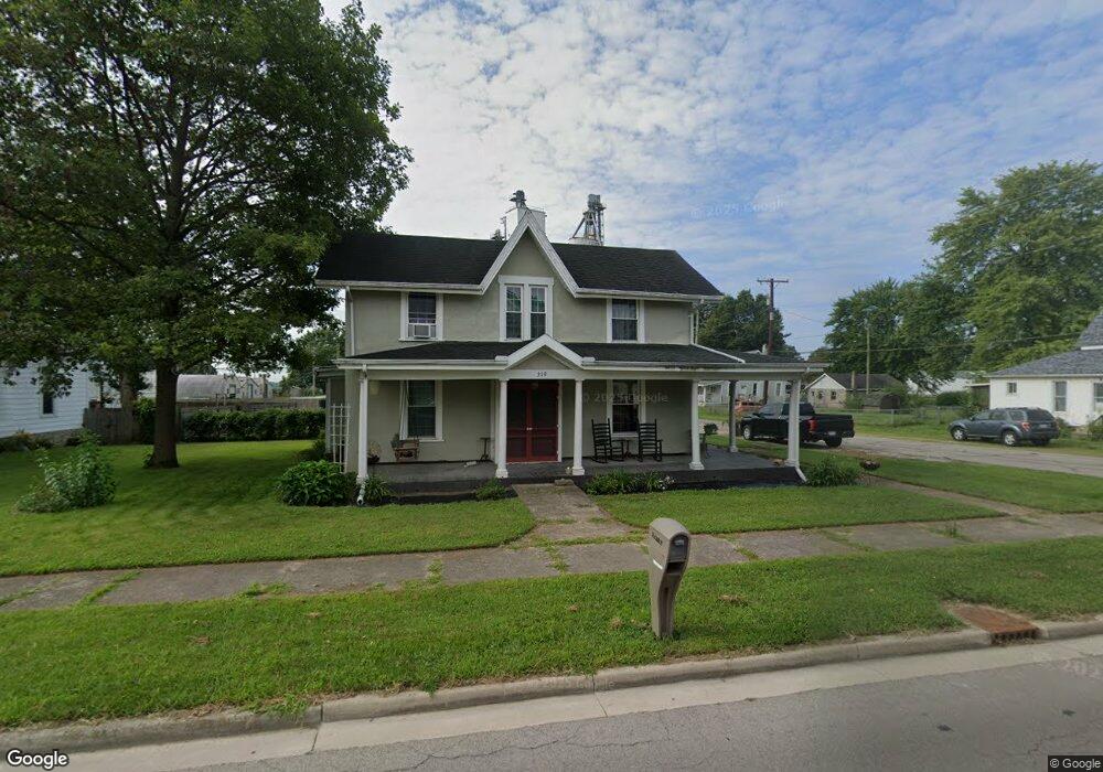
319 W Baird St West Liberty, OH 43357
Estimated Value: $211,000 - $368,000
3
Beds
2
Baths
2,506
Sq Ft
$104/Sq Ft
Est. Value
About This Home
This home is located at 319 W Baird St, West Liberty, OH 43357 and is currently estimated at $259,780, approximately $103 per square foot. 319 W Baird St is a home located in Logan County with nearby schools including West Liberty-Salem Elementary School, West Liberty-Salem Middle School, and West Liberty-Salem Middle/High School.
Ownership History
Date
Name
Owned For
Owner Type
Purchase Details
Closed on
Oct 27, 2016
Sold by
Daulton Julia A and Monroe Julia A
Bought by
Hale Carl K and Hale Lori J
Current Estimated Value
Home Financials for this Owner
Home Financials are based on the most recent Mortgage that was taken out on this home.
Original Mortgage
$130,150
Outstanding Balance
$104,685
Interest Rate
3.48%
Mortgage Type
New Conventional
Estimated Equity
$155,095
Purchase Details
Closed on
Jul 5, 2012
Sold by
Hughes Kenneth L and Hughes Clara E
Bought by
Daulton Julia A
Purchase Details
Closed on
Nov 4, 2008
Bought by
Hughes Kenneth L
Purchase Details
Closed on
Jun 3, 2008
Bought by
Liquidation Properties Inc
Purchase Details
Closed on
Aug 10, 2006
Bought by
Neeld Joseph H
Purchase Details
Closed on
Apr 27, 1999
Bought by
Neeld Ruth A
Create a Home Valuation Report for This Property
The Home Valuation Report is an in-depth analysis detailing your home's value as well as a comparison with similar homes in the area
Home Values in the Area
Average Home Value in this Area
Purchase History
| Date | Buyer | Sale Price | Title Company |
|---|---|---|---|
| Hale Carl K | $137,500 | None Available | |
| Daulton Julia A | -- | -- | |
| Hughes Kenneth L | $41,000 | -- | |
| Liquidation Properties Inc | $50,000 | -- | |
| Neeld Joseph H | $110,000 | -- | |
| Neeld Ruth A | -- | -- |
Source: Public Records
Mortgage History
| Date | Status | Borrower | Loan Amount |
|---|---|---|---|
| Open | Hale Carl K | $130,150 |
Source: Public Records
Tax History Compared to Growth
Tax History
| Year | Tax Paid | Tax Assessment Tax Assessment Total Assessment is a certain percentage of the fair market value that is determined by local assessors to be the total taxable value of land and additions on the property. | Land | Improvement |
|---|---|---|---|---|
| 2024 | $2,454 | $62,650 | $13,370 | $49,280 |
| 2023 | $2,454 | $62,650 | $13,370 | $49,280 |
| 2022 | $2,456 | $52,210 | $11,140 | $41,070 |
| 2021 | $2,191 | $52,210 | $11,140 | $41,070 |
| 2020 | $2,195 | $49,110 | $9,260 | $39,850 |
| 2019 | $2,197 | $49,110 | $9,260 | $39,850 |
| 2018 | $2,049 | $49,110 | $9,260 | $39,850 |
| 2016 | $1,960 | $44,650 | $8,420 | $36,230 |
| 2014 | $1,895 | $44,650 | $8,420 | $36,230 |
| 2013 | $1,876 | $44,650 | $8,420 | $36,230 |
| 2012 | $1,378 | $36,130 | $6,940 | $29,190 |
Source: Public Records
Map
Nearby Homes
- 512 W Columbus St
- 308 Reynolds St
- 619 W Baird St
- 215 N Detroit St
- 116 E Newell St
- 414 N Detroit St
- 0 County Road 189
- . Co Rd 189
- 5714 Hickory Dr
- Lot 1 County Road 1
- 129 Tanglewood Dr
- 5197 County Road 1
- 4124 State Route 245 W
- 7885 N Ludlow Rd
- 4164 County Road 1
- 6404 Township Road 55
- Lot 3 County Road 1
- Lot 2 County Road 1
- Lot 1 County Road 1
- 4416 N US Highway 68
- 311 W Baird St
- 401 W Baird St
- 307 W Baird St
- 405 W Baird St
- 320 W Baird St
- 305 W Baird St
- 316 W Baird St
- 112 Fuson St
- 312 W Baird St
- 301 W Baird St
- 404 W Baird St
- 310 W Baird St
- 116 Fuson St
- 410 W Baird St
- 300 Runkle St
- 300 W Baird St
- 412 W Baird St
- 319 W Columbus St
- 315 W Columbus St
- 217 W Baird St