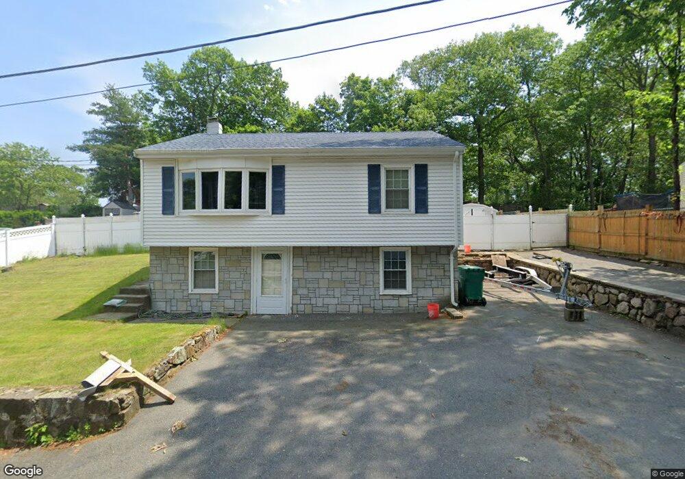
32 Allston St Lynn, MA 01904
Lynn Woods NeighborhoodEstimated Value: $517,000 - $569,000
3
Beds
2
Baths
970
Sq Ft
$570/Sq Ft
Est. Value
About This Home
This home is located at 32 Allston St, Lynn, MA 01904 and is currently estimated at $552,741, approximately $569 per square foot. 32 Allston St is a home located in Essex County with nearby schools including Lynn Woods Elementary School, William R. Fallon School, and Pickering Middle School.
Ownership History
Date
Name
Owned For
Owner Type
Purchase Details
Closed on
Oct 10, 2006
Sold by
Codair Charles D and Codair James J
Bought by
Codair Charles J and Codair Charles D
Current Estimated Value
Home Financials for this Owner
Home Financials are based on the most recent Mortgage that was taken out on this home.
Original Mortgage
$142,450
Interest Rate
6.54%
Mortgage Type
Purchase Money Mortgage
Create a Home Valuation Report for This Property
The Home Valuation Report is an in-depth analysis detailing your home's value as well as a comparison with similar homes in the area
Home Values in the Area
Average Home Value in this Area
Purchase History
| Date | Buyer | Sale Price | Title Company |
|---|---|---|---|
| Codair Charles J | $185,000 | -- | |
| Codair Charles J | $185,000 | -- |
Source: Public Records
Mortgage History
| Date | Status | Borrower | Loan Amount |
|---|---|---|---|
| Open | Codair Charles J | $180,000 | |
| Closed | Codair Charles J | $142,450 | |
| Closed | Codair Charles J | $37,000 | |
| Closed | Codair Charles J | $10,445 |
Source: Public Records
Tax History Compared to Growth
Tax History
| Year | Tax Paid | Tax Assessment Tax Assessment Total Assessment is a certain percentage of the fair market value that is determined by local assessors to be the total taxable value of land and additions on the property. | Land | Improvement |
|---|---|---|---|---|
| 2025 | $4,819 | $465,200 | $224,400 | $240,800 |
| 2024 | $4,438 | $421,500 | $215,100 | $206,400 |
| 2023 | $4,672 | $419,000 | $239,600 | $179,400 |
| 2022 | $3,894 | $313,300 | $173,600 | $139,700 |
| 2021 | $4,061 | $311,700 | $167,200 | $144,500 |
| 2020 | $3,991 | $297,800 | $157,900 | $139,900 |
| 2019 | $3,850 | $269,200 | $133,000 | $136,200 |
| 2018 | $4,224 | $278,800 | $159,900 | $118,900 |
| 2017 | $3,839 | $246,100 | $149,100 | $97,000 |
| 2016 | $3,757 | $232,200 | $138,900 | $93,300 |
| 2015 | $3,725 | $222,400 | $137,400 | $85,000 |
Source: Public Records
Map
Nearby Homes
- 75 Park Rd
- 18 Woodrow Terrace
- 21 Cannon View Cir
- 35 Oak Ridge Cir
- 68 Sutcliffe Rd
- 2 Anchor Rd
- 101 Kernwood Dr
- 12 Kernwood Dr
- 54 Harris Rd
- 186 Woodland N
- 16 Vieira Dr
- 217 Cedar Brook Rd
- 69 Saunders Rd
- 38 Great Woods Terrace
- 325 Den Quarry Rd
- 74 Fairview Ave
- 52 Savory St
- 20 Roanoke St
- 115 Quinn Rd
- 64 Bacheller St
- 28 Allston St
- 40 Allston St
- 11 Parker Hill Terrace
- 15 Parker Hill Terrace
- 14 Priscilla Way
- 9 Parker Hill Terrace
- 24 Allston St
- 46 Allston St
- 19 Allston St
- 23 Allston St
- 22 Priscilla Way
- 3 Parker Hill Terrace
- 8 Parker Hill Terrace
- 54 Trevett Ave
- 50 Trevett Ave
- 50 Allston St
- 26 Priscilla Way
- 35 Parker Hill Ave
- 44 Trevett Ave
- 22 Parker Hill Ave