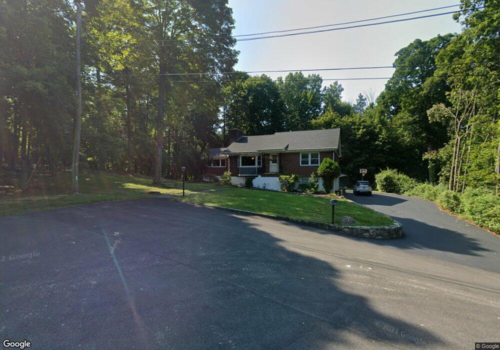
32 Angela Dr Croton On Hudson, NY 10520
Estimated Value: $698,000 - $942,000
--
Bed
--
Bath
--
Sq Ft
0.36
Acres
About This Home
This home is located at 32 Angela Dr, Croton On Hudson, NY 10520 and is currently estimated at $780,983. 32 Angela Dr is a home located in Westchester County with nearby schools including Frank G. Lindsey Elementary School, Blue Mountain Middle School, and Hendrick Hudson High School.
Ownership History
Date
Name
Owned For
Owner Type
Purchase Details
Closed on
Nov 14, 2001
Sold by
Weissner Michael D and Weissner Ursula M
Bought by
Corkery Cornelius and Corkery Barbara
Current Estimated Value
Home Financials for this Owner
Home Financials are based on the most recent Mortgage that was taken out on this home.
Original Mortgage
$200,000
Interest Rate
6.84%
Mortgage Type
Unknown
Purchase Details
Closed on
Sep 30, 1997
Sold by
Weissner Jerome and Weissner Jeannette
Bought by
Weissner Michael D and Weissner Ursula M
Create a Home Valuation Report for This Property
The Home Valuation Report is an in-depth analysis detailing your home's value as well as a comparison with similar homes in the area
Home Values in the Area
Average Home Value in this Area
Purchase History
| Date | Buyer | Sale Price | Title Company |
|---|---|---|---|
| Corkery Cornelius | $321,000 | -- | |
| Weissner Michael D | $175,000 | First American Title Ins Co |
Source: Public Records
Mortgage History
| Date | Status | Borrower | Loan Amount |
|---|---|---|---|
| Previous Owner | Corkery Cornelius | $200,000 |
Source: Public Records
Tax History Compared to Growth
Tax History
| Year | Tax Paid | Tax Assessment Tax Assessment Total Assessment is a certain percentage of the fair market value that is determined by local assessors to be the total taxable value of land and additions on the property. | Land | Improvement |
|---|---|---|---|---|
| 2024 | $8,274 | $6,575 | $900 | $5,675 |
| 2023 | $9,805 | $6,575 | $900 | $5,675 |
| 2022 | $9,748 | $6,575 | $900 | $5,675 |
| 2021 | $9,516 | $6,575 | $900 | $5,675 |
| 2020 | $9,254 | $6,575 | $900 | $5,675 |
| 2019 | $10,254 | $6,575 | $900 | $5,675 |
| 2018 | $8,569 | $6,575 | $900 | $5,675 |
| 2017 | $3,340 | $6,575 | $900 | $5,675 |
| 2016 | $9,999 | $6,575 | $900 | $5,675 |
| 2015 | -- | $6,575 | $900 | $5,675 |
| 2014 | -- | $6,575 | $900 | $5,675 |
| 2013 | -- | $6,575 | $900 | $5,675 |
Source: Public Records
Map
Nearby Homes
- 0 Laurel Hill Rd Unit KEY925925
- 114 Laurel Hill Rd
- 110 Laurel Hill Rd
- 149 Cortlandt St
- 11 Deer Haunt Dr
- 12 Scenic Dr Unit K
- 13 Scenic Dr Unit M
- 13 Scenic Dr Unit D
- 14 Scenic Dr Unit 14T
- 15 Scenic Dr Unit D
- 15 Scenic Dr Unit K
- 14 Amalfi Dr
- 16 Scenic Dr Unit X
- 16 Scenic Dr Unit S
- 16 Scenic Dr Unit N
- 16 Scenic Dr Unit M
- 5 Robin Ln
- 49 Henning Dr
- 23 Meadow Rd
- 196 Furnace Dock Rd
- 28 Angela Dr
- 24 Angela Dr
- 27 Angela Dr
- 25 Angela Dr
- 55 Laurel Hill Rd Unit C
- 55 Laurel Hill Rd
- 20 Angela Dr
- 17 Angela Dr
- 7 Angela Dr
- 413 Springvale Rd
- 53 Laurel Hill Rd
- 3 Angela Dr
- 16 Angela Dr
- 51 Laurel Hill Rd Unit B
- 51 Laurel Hill Rd
- 51A Laurel Hill Rd
- 14 Summit Place
- 14 Angela Dr
- 1 Angela Dr
- 8 Angela Dr