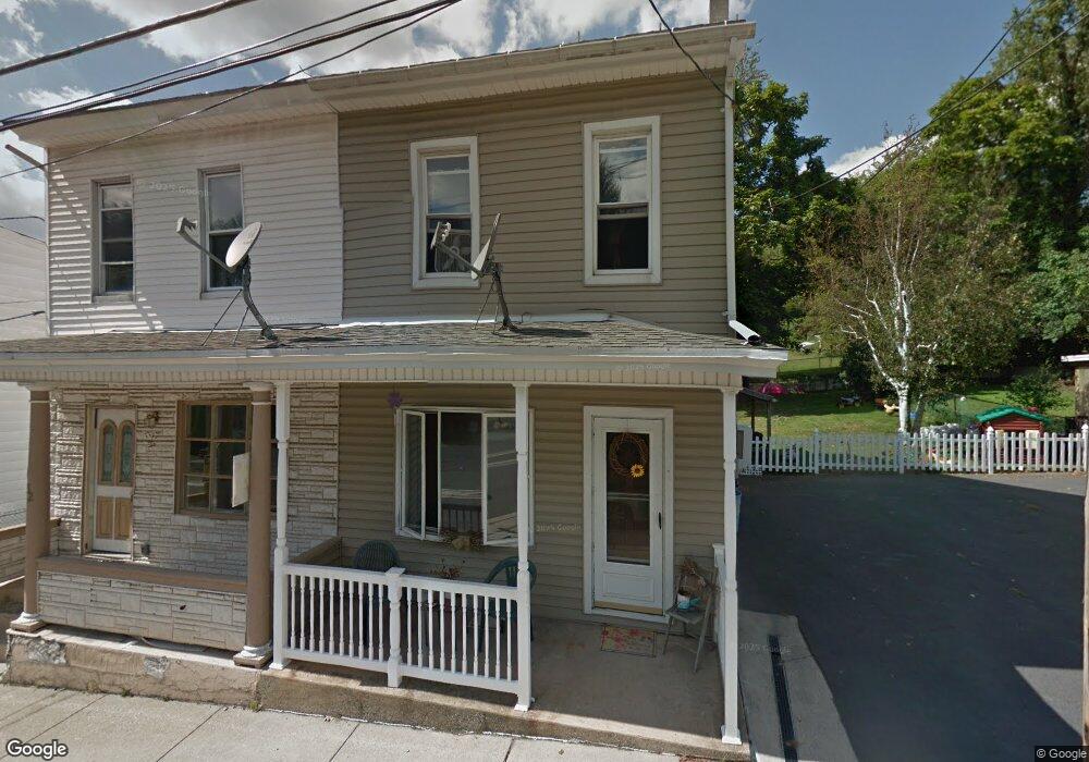
32 Ann St Pottsville, PA 17901
Estimated Value: $61,000 - $134,000
3
Beds
2
Baths
1,152
Sq Ft
$81/Sq Ft
Est. Value
About This Home
This home is located at 32 Ann St, Pottsville, PA 17901 and is currently estimated at $93,116, approximately $80 per square foot. 32 Ann St is a home with nearby schools including Saint Clair Area Elementary/Middle School, Gillingham Charter School, and ASSUMPTION BVM SCHOOL.
Ownership History
Date
Name
Owned For
Owner Type
Purchase Details
Closed on
Sep 29, 2017
Sold by
Djh Properties Llc
Bought by
Acorn Estates Llc
Current Estimated Value
Purchase Details
Closed on
May 1, 2017
Sold by
Cope Raymond J
Bought by
Djh Properties Llc
Purchase Details
Closed on
Nov 23, 2016
Sold by
Schwab William G and Apartments And Acquisitions Lp
Bought by
Cope Raymond J
Purchase Details
Closed on
Jan 31, 2011
Sold by
Natural Realty Llc
Bought by
Apartments & Acquisitions Limited Partne
Purchase Details
Closed on
Aug 24, 2010
Sold by
Schuylkill County Tax Claim Bureau
Bought by
Natural Realty Llc
Create a Home Valuation Report for This Property
The Home Valuation Report is an in-depth analysis detailing your home's value as well as a comparison with similar homes in the area
Home Values in the Area
Average Home Value in this Area
Purchase History
| Date | Buyer | Sale Price | Title Company |
|---|---|---|---|
| Acorn Estates Llc | -- | None Available | |
| Djh Properties Llc | -- | Lighthouse Abstract | |
| Cope Raymond J | $5,000 | None Available | |
| Apartments & Acquisitions Limited Partne | $10,000 | None Available | |
| Natural Realty Llc | $6,600 | None Available |
Source: Public Records
Tax History Compared to Growth
Tax History
| Year | Tax Paid | Tax Assessment Tax Assessment Total Assessment is a certain percentage of the fair market value that is determined by local assessors to be the total taxable value of land and additions on the property. | Land | Improvement |
|---|---|---|---|---|
| 2025 | $295 | $4,490 | $750 | $3,740 |
| 2024 | $276 | $4,490 | $750 | $3,740 |
| 2023 | $263 | $4,490 | $750 | $3,740 |
| 2022 | $263 | $4,490 | $750 | $3,740 |
| 2021 | $265 | $4,490 | $750 | $3,740 |
| 2020 | $265 | $4,490 | $750 | $3,740 |
| 2018 | $830 | $14,335 | $3,000 | $11,335 |
| 2017 | $798 | $14,335 | $3,000 | $11,335 |
| 2015 | -- | $14,335 | $3,000 | $11,335 |
| 2011 | -- | $14,335 | $0 | $0 |
Source: Public Records
Map
Nearby Homes
- 438 S Front St
- 219 S 3rd St
- 122 S 3rd St
- 320 S Mill St
- 101 S 2nd St
- 20 S 2nd St
- 108 Cherry St
- 32 S Front St
- 225 Cherry St
- 48 N 2nd St
- 145 Chamberlaine Ave
- 702 & 698 Port Carbon St Clair Hwy
- 212 Broad St
- 665 Port Carbon Saint Clair Hwy
- 0 Caroline Ave Unit PASK2022658
- 311 Broad St
- 309 Chestnut St
- 144 N Mill St
- Lot 30 Elmwood Ct
- 0 - Lot 10 Elmwood Ct Unit 10