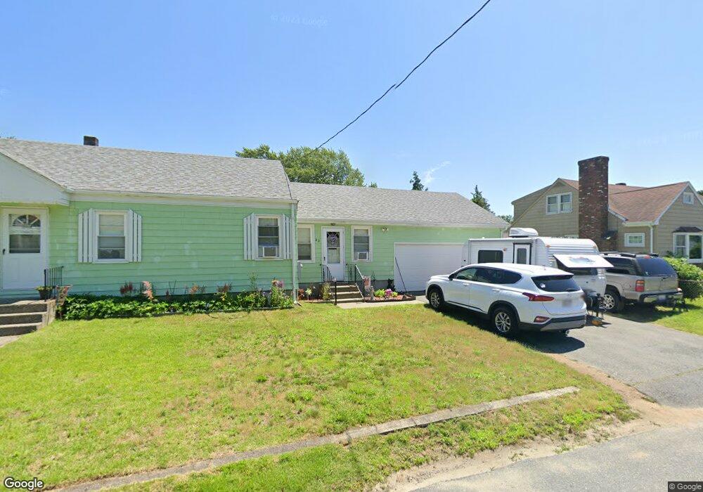
32 Anthony Ave Swansea, MA 02777
Ocean Grove NeighborhoodEstimated Value: $361,000 - $422,938
3
Beds
1
Bath
1,104
Sq Ft
$353/Sq Ft
Est. Value
About This Home
This home is located at 32 Anthony Ave, Swansea, MA 02777 and is currently estimated at $390,235, approximately $353 per square foot. 32 Anthony Ave is a home located in Bristol County with nearby schools including Joseph Case High School and Swansea Wood School.
Ownership History
Date
Name
Owned For
Owner Type
Purchase Details
Closed on
Jan 16, 2025
Sold by
Monteiro Lorraine B
Bought by
Monteiro Lorraine B and Monteiro David A
Current Estimated Value
Home Financials for this Owner
Home Financials are based on the most recent Mortgage that was taken out on this home.
Original Mortgage
$100,000
Outstanding Balance
$99,277
Interest Rate
6.6%
Mortgage Type
New Conventional
Estimated Equity
$290,958
Purchase Details
Closed on
Sep 17, 2007
Sold by
Martin Denise J and Turgeon Denise J
Bought by
Monteiro Lorraine B
Purchase Details
Closed on
Jan 11, 2005
Sold by
Stlaurent Jeannine
Bought by
Martin Denise J and Monteiro Lorraine B
Purchase Details
Closed on
Aug 23, 1961
Bought by
Stlaurent Jeannine
Create a Home Valuation Report for This Property
The Home Valuation Report is an in-depth analysis detailing your home's value as well as a comparison with similar homes in the area
Home Values in the Area
Average Home Value in this Area
Purchase History
| Date | Buyer | Sale Price | Title Company |
|---|---|---|---|
| Monteiro Lorraine B | -- | None Available | |
| Monteiro Lorraine B | -- | -- | |
| Martin Denise J | -- | -- | |
| Stlaurent Jeannine | -- | -- |
Source: Public Records
Mortgage History
| Date | Status | Borrower | Loan Amount |
|---|---|---|---|
| Open | Monteiro Lorraine B | $100,000 | |
| Previous Owner | Stlaurent Jeannine | $14,000 | |
| Previous Owner | Stlaurent Jeannine | $35,000 |
Source: Public Records
Tax History Compared to Growth
Tax History
| Year | Tax Paid | Tax Assessment Tax Assessment Total Assessment is a certain percentage of the fair market value that is determined by local assessors to be the total taxable value of land and additions on the property. | Land | Improvement |
|---|---|---|---|---|
| 2025 | $3,934 | $330,000 | $149,000 | $181,000 |
| 2024 | $3,921 | $327,000 | $149,000 | $178,000 |
| 2023 | $3,751 | $285,700 | $111,000 | $174,700 |
| 2022 | $3,645 | $253,300 | $96,500 | $156,800 |
| 2021 | $3,385 | $216,600 | $96,700 | $119,900 |
| 2020 | $3,495 | $224,300 | $100,900 | $123,400 |
| 2019 | $3,260 | $210,200 | $86,800 | $123,400 |
| 2018 | $3,082 | $201,700 | $82,500 | $119,200 |
| 2017 | $2,631 | $198,100 | $78,900 | $119,200 |
| 2016 | $2,585 | $191,200 | $76,300 | $114,900 |
| 2015 | $2,357 | $179,500 | $76,300 | $103,200 |
| 2014 | $2,323 | $180,900 | $76,300 | $104,600 |
Source: Public Records
Map
Nearby Homes
- 15 Massasoit Ave
- 23 Massasoit Ave
- 42 Anthony Ave
- 22 Anthony Ave
- 29 Anthony Ave
- 39 Anthony Ave
- 143 Metacomet Ave
- 147 Metacomet Ave
- 19 Anthony Ave
- 131 Metacomet Ave
- 45 Anthony Ave
- 155 Metacomet Ave
- 58 Pinehurst Ave
- 22 Massasoit Ave
- 4 Massasoit Ave
- 13 Anthony Ave
- 140 Metacomet Ave
- 146 Metacomet Ave
- 51 Anthony Ave
- 134 Metacomet Ave