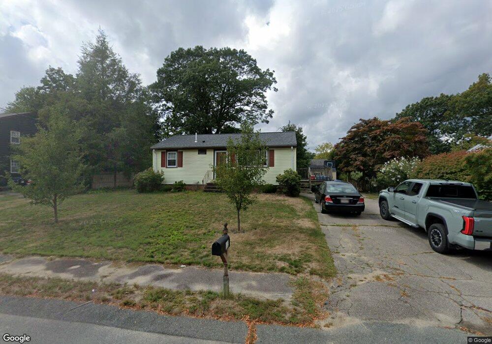
32 Apollo Rd Whitman, MA 02382
Estimated Value: $434,450 - $466,000
3
Beds
1
Bath
816
Sq Ft
$559/Sq Ft
Est. Value
About This Home
This home is located at 32 Apollo Rd, Whitman, MA 02382 and is currently estimated at $455,863, approximately $558 per square foot. 32 Apollo Rd is a home located in Plymouth County with nearby schools including St Bridget School.
Ownership History
Date
Name
Owned For
Owner Type
Purchase Details
Closed on
Jun 30, 2000
Sold by
Soule Deborah L
Bought by
Choufa Boualem and Delgado-Lemus Vilma R
Current Estimated Value
Home Financials for this Owner
Home Financials are based on the most recent Mortgage that was taken out on this home.
Original Mortgage
$147,000
Interest Rate
8.59%
Mortgage Type
Purchase Money Mortgage
Purchase Details
Closed on
Oct 3, 1995
Sold by
Markie William and Markie Joann
Bought by
Soule John E and Soule Debroah L
Purchase Details
Closed on
Feb 1, 1988
Sold by
Wolfgang Wiulliam P
Bought by
Markie William
Create a Home Valuation Report for This Property
The Home Valuation Report is an in-depth analysis detailing your home's value as well as a comparison with similar homes in the area
Home Values in the Area
Average Home Value in this Area
Purchase History
| Date | Buyer | Sale Price | Title Company |
|---|---|---|---|
| Choufa Boualem | $160,000 | -- | |
| Soule John E | $115,000 | -- | |
| Markie William | $135,000 | -- |
Source: Public Records
Mortgage History
| Date | Status | Borrower | Loan Amount |
|---|---|---|---|
| Open | Markie William | $169,500 | |
| Closed | Markie William | $146,422 | |
| Closed | Markie William | $147,000 |
Source: Public Records
Tax History
| Year | Tax Paid | Tax Assessment Tax Assessment Total Assessment is a certain percentage of the fair market value that is determined by local assessors to be the total taxable value of land and additions on the property. | Land | Improvement |
|---|---|---|---|---|
| 2025 | $4,701 | $358,300 | $193,000 | $165,300 |
| 2024 | $4,352 | $341,600 | $183,000 | $158,600 |
| 2023 | $4,386 | $323,200 | $175,100 | $148,100 |
| 2022 | $4,276 | $293,700 | $159,200 | $134,500 |
| 2021 | $4,253 | $274,400 | $149,200 | $125,200 |
| 2020 | $4,073 | $257,000 | $139,300 | $117,700 |
| 2019 | $3,850 | $250,300 | $139,300 | $111,000 |
| 2018 | $3,450 | $227,300 | $125,300 | $102,000 |
| 2017 | $3,428 | $227,300 | $125,300 | $102,000 |
| 2016 | $3,341 | $214,300 | $124,400 | $89,900 |
| 2015 | $3,345 | $214,300 | $124,400 | $89,900 |
Source: Public Records
Map
Nearby Homes
- 23 Reed Place
- 170 Pleasant St
- 291 Raynor Ave
- 1269 Whitman St
- 214 Winter St
- 608 Plymouth St
- 10 Proud Foot Way
- 289 Commercial St
- 14 Birch Bottom Cir
- 5 Alpine St
- 147 South Ave
- 110 South Ave
- 23 Live Oak Way
- 48 Day St
- 8 Laurel St
- 842 Whitman St
- 22 Howland Trail Unit 34
- 7 Hayford Trail Unit 12
- 5 Hayford Trail Unit 11
- 12 Hayford Trail Unit 17