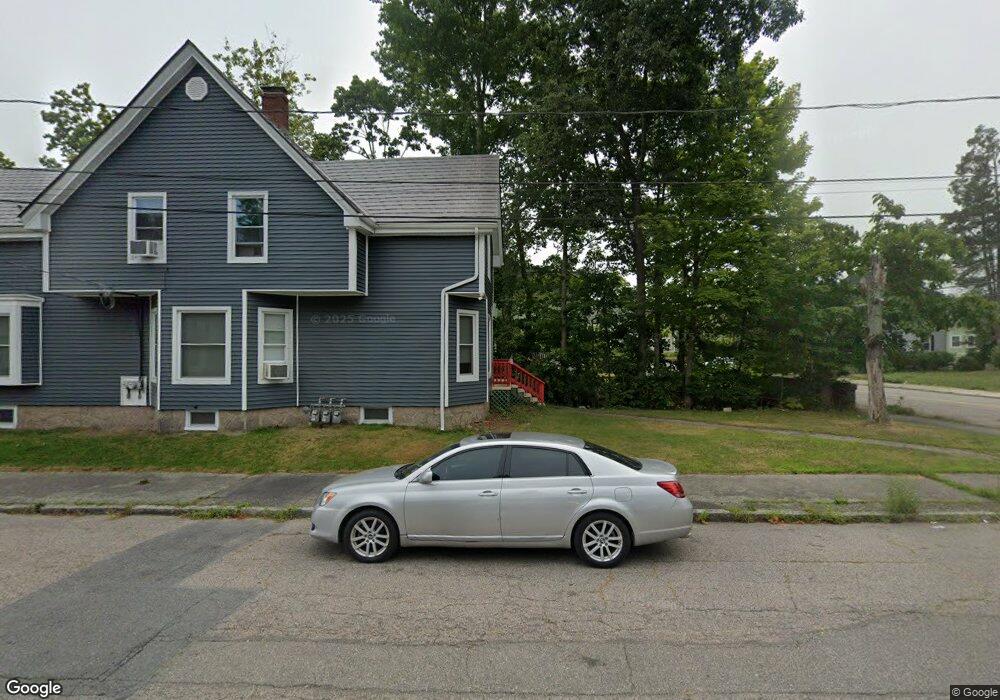
32 Ash St Brockton, MA 02301
Estimated Value: $482,327 - $580,000
3
Beds
1
Bath
1,528
Sq Ft
$335/Sq Ft
Est. Value
About This Home
This home is located at 32 Ash St, Brockton, MA 02301 and is currently estimated at $512,332, approximately $335 per square foot. 32 Ash St is a home located in Plymouth County with nearby schools including Manthala George Jr. School, Louis F Angelo Elementary School, and Raymond K-8 Elementary School.
Ownership History
Date
Name
Owned For
Owner Type
Purchase Details
Closed on
Feb 23, 1989
Sold by
Prewandowski Karen
Bought by
Jones Gerald M
Current Estimated Value
Create a Home Valuation Report for This Property
The Home Valuation Report is an in-depth analysis detailing your home's value as well as a comparison with similar homes in the area
Purchase History
| Date | Buyer | Sale Price | Title Company |
|---|---|---|---|
| Jones Gerald M | $135,000 | -- |
Source: Public Records
Mortgage History
| Date | Status | Borrower | Loan Amount |
|---|---|---|---|
| Open | Jones Gerald M | $237,500 | |
| Closed | Jones Gerald M | $222,000 | |
| Closed | Jones Gerald M | $141,216 | |
| Closed | Jones Gerald M | $133,995 |
Source: Public Records
Tax History
| Year | Tax Paid | Tax Assessment Tax Assessment Total Assessment is a certain percentage of the fair market value that is determined by local assessors to be the total taxable value of land and additions on the property. | Land | Improvement |
|---|---|---|---|---|
| 2025 | $5,044 | $416,500 | $140,200 | $276,300 |
| 2024 | $4,938 | $410,800 | $140,200 | $270,600 |
| 2023 | $4,984 | $384,000 | $105,000 | $279,000 |
| 2022 | $4,734 | $338,900 | $95,400 | $243,500 |
| 2021 | $4,238 | $292,300 | $79,400 | $212,900 |
| 2020 | $4,290 | $283,200 | $74,200 | $209,000 |
| 2019 | $3,857 | $248,200 | $72,400 | $175,800 |
| 2018 | $3,755 | $233,800 | $72,400 | $161,400 |
| 2017 | $3,639 | $226,000 | $72,400 | $153,600 |
| 2016 | $3,817 | $219,900 | $70,200 | $149,700 |
| 2015 | $3,528 | $194,400 | $70,200 | $124,200 |
| 2014 | $3,388 | $186,900 | $70,200 | $116,700 |
Source: Public Records
Map
Nearby Homes
- 4 Park Rd
- 21 Simmons Ave
- 48 Simmons Ave
- 35 Colonel Bell Dr Unit 35
- 72 W Elm Terrace
- 66 Cross Ave
- 29 Auna Dr Unit 3
- 75 Colonel Bell Dr Unit 77-11
- 7 N Winnifred Rd
- 11 Auna Dr Unit 10
- 11 Auna Dr Unit 6
- 47 N Belcher Ave
- 226 W Elm St
- 35 Brett St
- 56 N Warren Ave
- 10 Fitzpatrick Ave
- 60 Elm Ave
- 75 Thurber Ave
- 18 Walnut St
- 282 Belmont St
Your Personal Tour Guide
Ask me questions while you tour the home.