G
Seller's Agent in 2025
Gina Stoddard
The Firm
(781) 361-1262
4 in this area
12 Total Sales


Estimated Value: $861,592 - $913,000
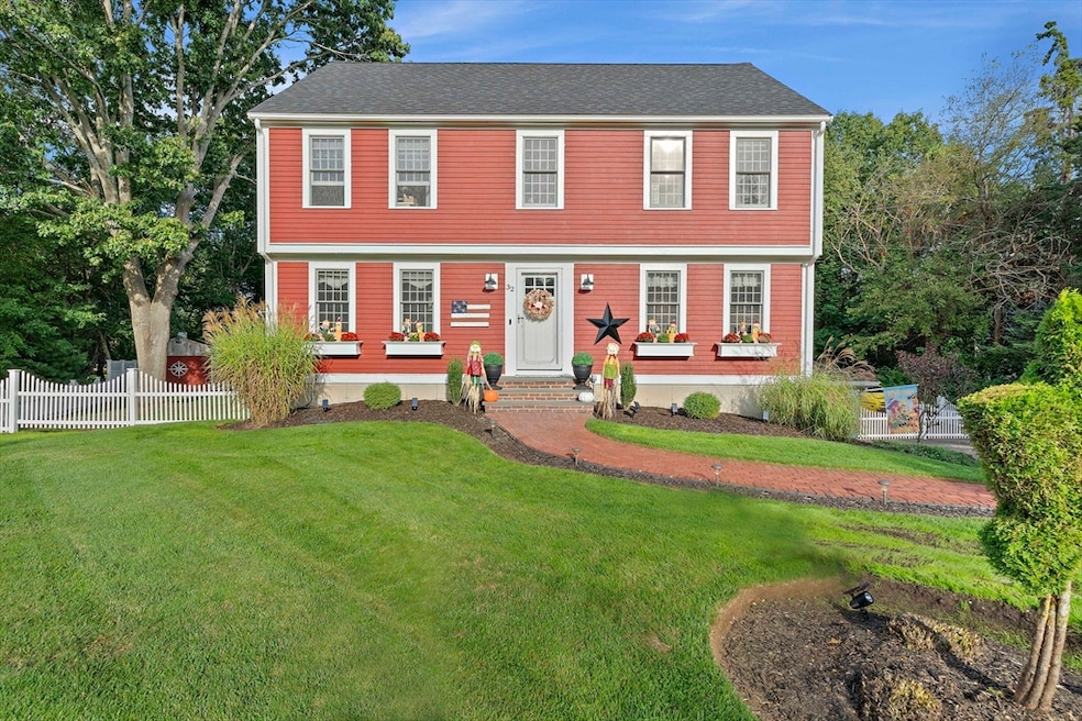
This beautiful 4-bedroom, 2.5-bath colonial is move-in ready and tucked away in a quiet neighborhood bordering the South River Inside, you’ll find a bright and welcoming layout with a spacious living room and cozy fireplace, a formal dining room that’s perfect for gatherings, and an updated kitchen with granite countertops, stainless steel appliances, and plenty of cabinet space.Upstairs, the primary suite has its own private bath and walk-in closet, while three additional bedrooms offer plenty of room for family, guests, or even a home office. The finished lower level adds extra living space that can easily be used as a playroom, gym, or media room.Recent updates include a brand-new roof, central air conditioning, and fresh exterior paint. Outside, the private fenced yard is beautifully landscaped and features a large deck, hot tub, pool, and lots of space to relax, play, or entertain. Conveniently located near beaches, schools, shopping, and restaurants, this home truly has it all!
We collect this data history from publicly available records. To have your information removed, we recommend requesting removal directly through your county’s website.
| Date | Buyer | Sale Price | Title Company |
|---|---|---|---|
| Horn Alexandria | $905,000 | -- | |
| Stoddard Stephen | -- | -- | |
| Stoddard Stephen A | -- | -- | |
| Stoddard Stephen A | -- | -- | |
| Serino Gina | -- | -- | |
| Serino Gina M | -- | -- | |
| Serino Joseph | $309,000 | -- | |
| Serino Joseph A | $309,000 | -- | |
| Falvey Todd | $277,000 | -- | |
| Falvey Todd M | $277,000 | -- | |
| Oconnor Barbara | $195,300 | -- | |
| Oconnor Barbara Y | $195,300 | -- |
We collect this data history from publicly available records. To have your information removed, we recommend requesting removal directly through your county’s website.
| Date | Status | Borrower | Loan Amount |
|---|---|---|---|
| Open | Horn Alexandria | $451,000 | |
| Previous Owner | Stoddard Stephen A | $351,180 |
| Date | Event | Price | List to Sale | Price per Sq Ft |
|---|---|---|---|---|
| 11/12/2025 11/12/25 | Sold | $905,000 | +5.4% | $406 / Sq Ft |
| 10/02/2025 10/02/25 | Pending | -- | -- | -- |
| 10/01/2025 10/01/25 | For Sale | $859,000 | -- | $385 / Sq Ft |
| Year | Tax Paid | Tax Assessment Tax Assessment Total Assessment is a certain percentage of the fair market value that is determined by local assessors to be the total taxable value of land and additions on the property. | Land | Improvement |
|---|---|---|---|---|
| 2025 | $7,205 | $727,800 | $303,800 | $424,000 |
| 2024 | $7,000 | $673,700 | $289,300 | $384,400 |
| 2023 | $6,498 | $591,400 | $258,300 | $333,100 |
| 2022 | $6,498 | $501,800 | $217,000 | $284,800 |
| 2021 | $6,240 | $473,100 | $217,000 | $256,100 |
| 2020 | $5,935 | $445,200 | $196,300 | $248,900 |
| 2019 | $5,764 | $430,800 | $196,300 | $234,500 |
| 2018 | $5,697 | $426,100 | $196,300 | $229,800 |
| 2017 | $5,610 | $408,900 | $196,300 | $212,600 |
| 2016 | $5,473 | $394,300 | $196,300 | $198,000 |
| 2015 | $5,176 | $389,500 | $196,300 | $193,200 |
| 2014 | $5,097 | $383,500 | $196,300 | $187,200 |
G
Seller's Agent in 2025
Gina Stoddard
The Firm
(781) 361-1262
4 in this area
12 Total Sales

Buyer's Agent in 2025
Melissa McNamara
William Raveis R.E. & Home Services
(781) 470-9503
6 in this area
168 Total Sales
Source: MLS Property Information Network (MLS PIN)
MLS Number: 73437688
APN: MARS-000009J-000008-000029
Disclaimer: Certain information contained herein is derived from information provided by parties other than Homes.com. All information provided is deemed reliable, but is not guaranteed to be accurate and should be independently verified.
![]() The property listing data and information, or the Images, set forth herein were provided to MLS Property Information Network, Inc. from third party sources, including sellers, lessors and public records, and were compiled by MLS Property Information Network, Inc. The property listing data and information, and the Images, are for the personal, non-commercial use of consumers having a good faith interest in purchasing or leasing listed properties of the type displayed to them and may not be used for any purpose other than to identify prospective properties which such consumers may have a good faith interest in purchasing or leasing. MLS Property Information Network, Inc. and its subscribers disclaim any and all representations and warranties as to the accuracy of the property listing data and information, or as to the accuracy of any of the Images, set forth herein.
The property listing data and information, or the Images, set forth herein were provided to MLS Property Information Network, Inc. from third party sources, including sellers, lessors and public records, and were compiled by MLS Property Information Network, Inc. The property listing data and information, and the Images, are for the personal, non-commercial use of consumers having a good faith interest in purchasing or leasing listed properties of the type displayed to them and may not be used for any purpose other than to identify prospective properties which such consumers may have a good faith interest in purchasing or leasing. MLS Property Information Network, Inc. and its subscribers disclaim any and all representations and warranties as to the accuracy of the property listing data and information, or as to the accuracy of any of the Images, set forth herein.
Ask me questions while you tour the home.