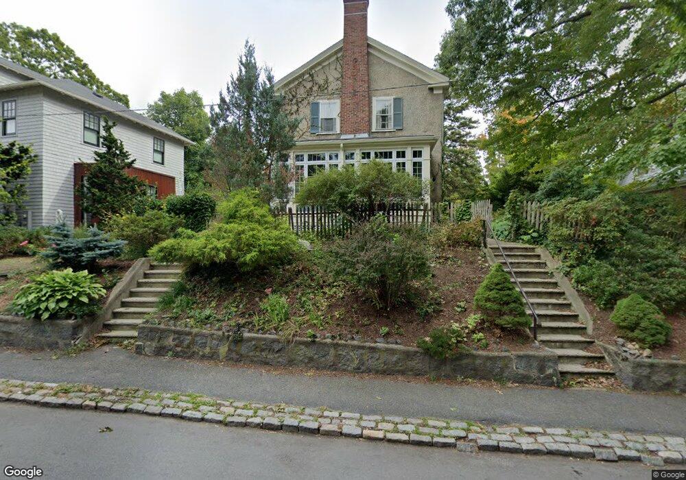
32 Bourne St Jamaica Plain, MA 02130
Jamaica Plain NeighborhoodEstimated Value: $802,000 - $1,086,000
3
Beds
2
Baths
1,536
Sq Ft
$592/Sq Ft
Est. Value
About This Home
This home is located at 32 Bourne St, Jamaica Plain, MA 02130 and is currently estimated at $908,805, approximately $591 per square foot. 32 Bourne St is a home located in Suffolk County with nearby schools including Brooke Charter School Roslindale, The Croft School - Jamaica Plain, and St. Clare High School.
Ownership History
Date
Name
Owned For
Owner Type
Purchase Details
Closed on
Jan 10, 1994
Sold by
Thuria Verploeg Thomas A and Thuria Surajaldeeni
Bought by
Gianino Mark and Gianino Mark S
Current Estimated Value
Home Financials for this Owner
Home Financials are based on the most recent Mortgage that was taken out on this home.
Original Mortgage
$134,900
Interest Rate
7.23%
Mortgage Type
Purchase Money Mortgage
Purchase Details
Closed on
Feb 13, 1987
Sold by
Cashman John J
Bought by
Verploeg Thomas A
Home Financials for this Owner
Home Financials are based on the most recent Mortgage that was taken out on this home.
Original Mortgage
$144,900
Interest Rate
9.34%
Mortgage Type
Purchase Money Mortgage
Create a Home Valuation Report for This Property
The Home Valuation Report is an in-depth analysis detailing your home's value as well as a comparison with similar homes in the area
Home Values in the Area
Average Home Value in this Area
Purchase History
| Date | Buyer | Sale Price | Title Company |
|---|---|---|---|
| Gianino Mark | $142,000 | -- | |
| Verploeg Thomas A | $161,000 | -- |
Source: Public Records
Mortgage History
| Date | Status | Borrower | Loan Amount |
|---|---|---|---|
| Closed | Gianino Mark | $134,900 | |
| Previous Owner | Verploeg Thomas A | $144,900 |
Source: Public Records
Tax History Compared to Growth
Tax History
| Year | Tax Paid | Tax Assessment Tax Assessment Total Assessment is a certain percentage of the fair market value that is determined by local assessors to be the total taxable value of land and additions on the property. | Land | Improvement |
|---|---|---|---|---|
| 2025 | $8,899 | $768,500 | $259,100 | $509,400 |
| 2024 | $8,489 | $778,800 | $237,000 | $541,800 |
| 2023 | $7,815 | $727,700 | $221,500 | $506,200 |
| 2022 | $7,261 | $667,400 | $203,100 | $464,300 |
| 2021 | $6,913 | $647,900 | $197,200 | $450,700 |
| 2020 | $6,059 | $573,800 | $188,800 | $385,000 |
| 2019 | $5,745 | $545,100 | $156,100 | $389,000 |
| 2018 | $5,100 | $486,600 | $156,100 | $330,500 |
| 2017 | $5,055 | $477,300 | $156,100 | $321,200 |
| 2016 | $5,147 | $467,900 | $156,100 | $311,800 |
| 2015 | $5,107 | $421,700 | $147,700 | $274,000 |
| 2014 | $4,645 | $369,200 | $147,700 | $221,500 |
Source: Public Records
Map
Nearby Homes
- 31 Rodman St Unit 2
- 31 Rodman St Unit 1
- 140 Wachusett St
- 158 Wachusett St Unit 3
- 50 Southbourne Rd
- 18-20 Northbourne Rd Unit 18
- 178 Hyde Park Ave Unit 3
- 143-171 Hyde Park Ave Unit 169A
- 348-350 Hyde Park Ave Unit 2
- 173 Brookway Rd
- 24 Waterman Rd
- 58 Weld Hill St Unit 2
- 64 Hyde Park Ave Unit 3
- 19 Delford St
- 19 Delford St Unit 1
- 602 Canterbury St Unit 14
- 602 Canterbury St Unit 4
- 602 Canterbury St Unit 5
- 602 Canterbury St Unit 2
- 602 Canterbury St Unit 9