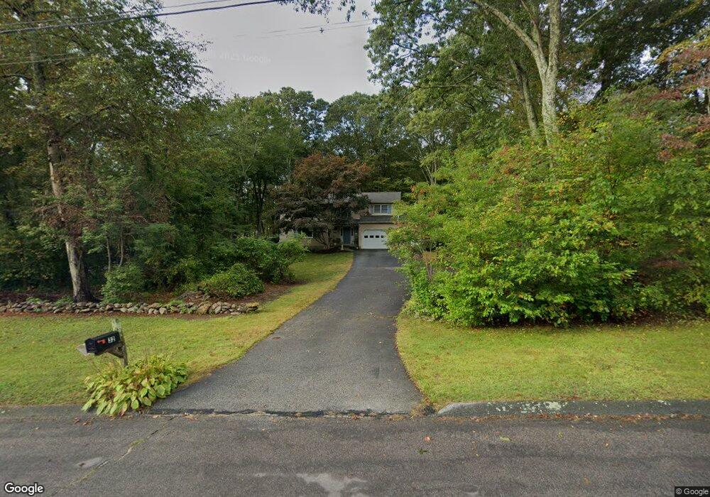
32 Chriswood Trace Ledyard, CT 06339
Estimated Value: $522,355 - $630,000
4
Beds
4
Baths
2,340
Sq Ft
$241/Sq Ft
Est. Value
About This Home
This home is located at 32 Chriswood Trace, Ledyard, CT 06339 and is currently estimated at $564,839, approximately $241 per square foot. 32 Chriswood Trace is a home located in New London County with nearby schools including Ledyard Middle School and Ledyard High School.
Ownership History
Date
Name
Owned For
Owner Type
Purchase Details
Closed on
Jun 30, 2021
Sold by
Olsson John D
Bought by
Olsson Joyce R
Current Estimated Value
Purchase Details
Closed on
Apr 20, 2021
Sold by
Salisbury Angel
Bought by
Dubois Jacqueline and Harrison Andrew
Purchase Details
Closed on
Apr 29, 1988
Sold by
Hlm Dev Inc
Bought by
Olsson John
Home Financials for this Owner
Home Financials are based on the most recent Mortgage that was taken out on this home.
Original Mortgage
$150,000
Interest Rate
9.86%
Mortgage Type
Purchase Money Mortgage
Create a Home Valuation Report for This Property
The Home Valuation Report is an in-depth analysis detailing your home's value as well as a comparison with similar homes in the area
Home Values in the Area
Average Home Value in this Area
Purchase History
| Date | Buyer | Sale Price | Title Company |
|---|---|---|---|
| Olsson Joyce R | -- | None Available | |
| Olsson Joyce R | -- | None Available | |
| Dubois Jacqueline | -- | None Available | |
| Olsson John | $215,000 | -- |
Source: Public Records
Mortgage History
| Date | Status | Borrower | Loan Amount |
|---|---|---|---|
| Previous Owner | Olsson John | $150,000 |
Source: Public Records
Tax History
| Year | Tax Paid | Tax Assessment Tax Assessment Total Assessment is a certain percentage of the fair market value that is determined by local assessors to be the total taxable value of land and additions on the property. | Land | Improvement |
|---|---|---|---|---|
| 2025 | $7,974 | $214,690 | $55,370 | $159,320 |
| 2024 | $7,559 | $214,690 | $55,370 | $159,320 |
| 2023 | $7,420 | $214,690 | $55,370 | $159,320 |
| 2022 | $7,261 | $214,690 | $55,370 | $159,320 |
| 2021 | $7,214 | $214,690 | $55,370 | $159,320 |
| 2020 | $6,289 | $179,830 | $40,250 | $139,580 |
| 2019 | $6,305 | $179,830 | $40,250 | $139,580 |
| 2018 | $6,166 | $179,830 | $40,250 | $139,580 |
| 2017 | $5,852 | $179,830 | $40,250 | $139,580 |
| 2016 | $5,737 | $179,830 | $40,250 | $139,580 |
| 2015 | $5,467 | $179,830 | $40,250 | $139,580 |
| 2014 | $6,253 | $207,200 | $60,340 | $146,860 |
Source: Public Records
Map
Nearby Homes
- 1661 Center Groton Rd
- 1541 North Rd
- 33 Forest Ave
- 419 Colonel Ledyard Hwy
- 1459 Gold Star Hwy
- 459 Colonel Ledyard Hwy
- 497 Colonel Ledyard Hwy
- 2590 Gold Star Hwy Unit 110
- 1 Marcel Rd
- 27 Marty's Way
- 25 Marty's Way
- 18 Marty's Way
- 98 Oslo St
- 69 Wendell Comrie Rd
- 669 Colonel Ledyard Hwy
- 16 Marty's Way
- 33 Cindy Ln
- 510 Flanders Rd
- 14 Pennywise Ln
- 1010 Long Cove Rd Unit LOT 23
- 30 Chriswood Trace
- 33 Chriswood Trace
- 34 Chriswood Trace
- 21 Barton Ln
- 19 Barton Ln
- 36 Chriswood Trace
- 31 Chriswood Trace
- 25 Barton Ln
- 29 Chriswood Trace
- 28 Chriswood Trace
- 17 Barton Ln
- 37 Chriswood Trace
- 27 Chriswood Trace
- 26 Chriswood Trace
- 15 Barton Ln
- 18 Barton Ln
- 22 Barton Ln
- 16 Barton Ln
- 29 Barton Ln
- 39 Chriswood Trace
Your Personal Tour Guide
Ask me questions while you tour the home.