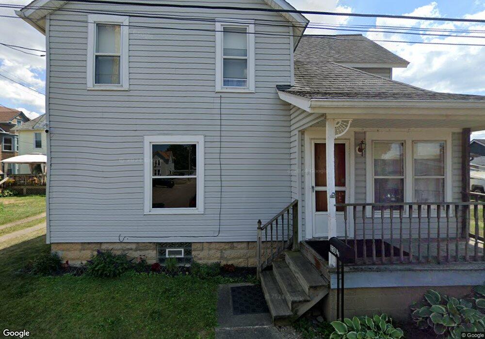
32 E High St Alliance, OH 44601
Estimated Value: $91,772 - $115,000
3
Beds
1
Bath
1,680
Sq Ft
$60/Sq Ft
Est. Value
About This Home
This home is located at 32 E High St, Alliance, OH 44601 and is currently estimated at $101,193, approximately $60 per square foot. 32 E High St is a home located in Stark County with nearby schools including Alliance Intermediate School at Northside, Alliance Elementary School at Rockhill, and Alliance Middle School.
Ownership History
Date
Name
Owned For
Owner Type
Purchase Details
Closed on
Dec 21, 2022
Sold by
Ledbetter Gregory E and Ledbetter Denice A
Bought by
Hennessey Linda L
Current Estimated Value
Purchase Details
Closed on
Aug 17, 2011
Sold by
Casto Clifford Ray and Casto Thomas Lee
Bought by
Heddy John H and Heddy Cynthia A
Home Financials for this Owner
Home Financials are based on the most recent Mortgage that was taken out on this home.
Original Mortgage
$66,397
Interest Rate
4.64%
Mortgage Type
VA
Purchase Details
Closed on
Sep 25, 2004
Sold by
Ledbetter Earl
Bought by
Ledbetter Gregory E and Ledbetter Denise A
Purchase Details
Closed on
Feb 25, 2000
Sold by
Earl Ledbetter
Bought by
Ledbetter Gregory E
Purchase Details
Closed on
Dec 27, 1999
Sold by
Ledbetter Gregory E and Ledbetter Denice A
Bought by
Ledbetter Earl
Purchase Details
Closed on
May 15, 1991
Purchase Details
Closed on
Apr 2, 1990
Create a Home Valuation Report for This Property
The Home Valuation Report is an in-depth analysis detailing your home's value as well as a comparison with similar homes in the area
Home Values in the Area
Average Home Value in this Area
Purchase History
| Date | Buyer | Sale Price | Title Company |
|---|---|---|---|
| Hennessey Linda L | $12,000 | -- | |
| Heddy John H | $65,000 | Attorney | |
| Ledbetter Gregory E | -- | -- | |
| Ledbetter Gregory E | -- | -- | |
| Ledbetter Earl | -- | -- | |
| -- | $26,000 | -- | |
| -- | $15,000 | -- |
Source: Public Records
Mortgage History
| Date | Status | Borrower | Loan Amount |
|---|---|---|---|
| Previous Owner | Heddy John H | $66,397 |
Source: Public Records
Tax History
| Year | Tax Paid | Tax Assessment Tax Assessment Total Assessment is a certain percentage of the fair market value that is determined by local assessors to be the total taxable value of land and additions on the property. | Land | Improvement |
|---|---|---|---|---|
| 2025 | $89 | $25,170 | $2,700 | $22,470 |
| 2024 | -- | $25,170 | $2,700 | $22,470 |
| 2023 | $1,013 | $16,630 | $1,470 | $15,160 |
| 2022 | $531 | $13,130 | $1,470 | $11,660 |
| 2021 | $532 | $13,130 | $1,470 | $11,660 |
| 2020 | $509 | $11,730 | $1,260 | $10,470 |
| 2019 | $501 | $11,730 | $1,260 | $10,470 |
| 2018 | $504 | $11,730 | $1,260 | $10,470 |
| 2017 | $443 | $10,150 | $1,050 | $9,100 |
| 2016 | $447 | $10,150 | $1,050 | $9,100 |
| 2015 | $450 | $10,150 | $1,050 | $9,100 |
| 2014 | $426 | $9,140 | $950 | $8,190 |
| 2013 | $213 | $9,140 | $950 | $8,190 |
Source: Public Records
Map
Nearby Homes
- 62 E High St
- 427 S Union Ave
- 0 E Oxford St
- 62 E Market St
- 163 W Market St
- 228 W Oxford St
- 361 E Main St
- 621 S Haines Ave
- 726 S Arch Ave
- 807 S Union Ave
- V/L S Freedom Ave
- 264 W Market St
- 452 E Summit St
- 46 Rosenberry St
- 234 Rosenberry St
- 231 Rosenberry St
- 118 S Mckinley Ave
- 203 Glamorgan St
- 535 S Mckinley Ave
- 226 Milner St
Your Personal Tour Guide
Ask me questions while you tour the home.