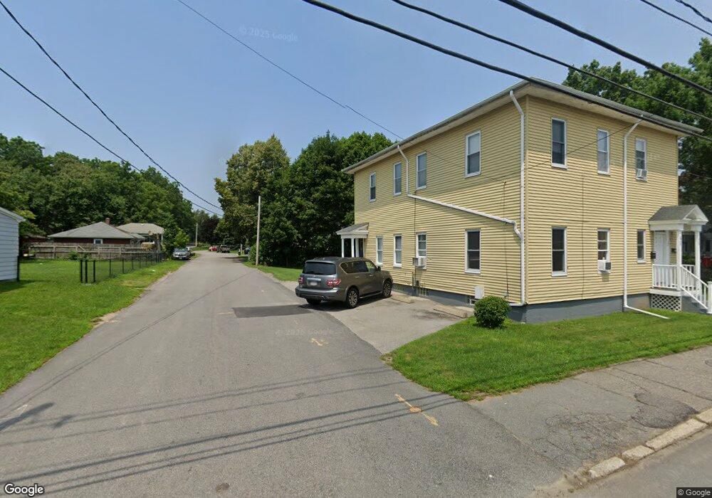
32 Everett St Somerset, MA 02726
Pottersville NeighborhoodEstimated Value: $434,838 - $537,000
4
Beds
1
Bath
1,152
Sq Ft
$412/Sq Ft
Est. Value
About This Home
This home is located at 32 Everett St, Somerset, MA 02726 and is currently estimated at $474,710, approximately $412 per square foot. 32 Everett St is a home located in Bristol County with nearby schools including North Elementary School, Somerset Middle School, and St. Michael's School.
Ownership History
Date
Name
Owned For
Owner Type
Purchase Details
Closed on
Dec 21, 2009
Sold by
Jenkinson James Est and Jenkinson
Bought by
Rudenauer Keith A and Rudenauer Meagan E
Current Estimated Value
Home Financials for this Owner
Home Financials are based on the most recent Mortgage that was taken out on this home.
Original Mortgage
$192,409
Outstanding Balance
$125,126
Interest Rate
5%
Mortgage Type
Purchase Money Mortgage
Estimated Equity
$349,584
Create a Home Valuation Report for This Property
The Home Valuation Report is an in-depth analysis detailing your home's value as well as a comparison with similar homes in the area
Home Values in the Area
Average Home Value in this Area
Purchase History
| Date | Buyer | Sale Price | Title Company |
|---|---|---|---|
| Rudenauer Keith A | $196,000 | -- | |
| Rudenauer Keith A | $196,000 | -- |
Source: Public Records
Mortgage History
| Date | Status | Borrower | Loan Amount |
|---|---|---|---|
| Open | Rudenauer Keith A | $192,409 | |
| Closed | Rudenauer Keith A | $192,409 |
Source: Public Records
Tax History
| Year | Tax Paid | Tax Assessment Tax Assessment Total Assessment is a certain percentage of the fair market value that is determined by local assessors to be the total taxable value of land and additions on the property. | Land | Improvement |
|---|---|---|---|---|
| 2025 | $4,656 | $350,100 | $178,600 | $171,500 |
| 2024 | $4,367 | $341,400 | $178,600 | $162,800 |
| 2023 | $3,847 | $303,400 | $155,100 | $148,300 |
| 2022 | $3,540 | $266,400 | $133,700 | $132,700 |
| 2021 | $3,564 | $242,800 | $120,700 | $122,100 |
| 2020 | $3,450 | $226,700 | $120,800 | $105,900 |
| 2019 | $3,951 | $216,500 | $120,800 | $95,700 |
| 2018 | $3,443 | $203,000 | $116,400 | $86,600 |
| 2017 | $3,369 | $193,600 | $111,000 | $82,600 |
| 2016 | $3,390 | $193,600 | $111,000 | $82,600 |
| 2015 | $3,211 | $185,100 | $109,200 | $75,900 |
| 2014 | $4,398 | $182,100 | $109,200 | $72,900 |
Source: Public Records
Map
Nearby Homes
- 2714 Riverside Ave
- 54 Grant Ave
- 3636 N Main St Unit 5
- 210 Harrison Ave
- 4234 N Main St Unit 103
- 3216 N Main St
- 46 Lilac Ave
- 145 Mount Hope Rd
- 22 Apple Creek Ln
- 0 Bark St Unit 1342599
- 0 Bark St Unit 73152576
- 1553 Riverside Ave
- 1496 Riverside Ave
- 33 Warner St
- 745 Bark St
- 34 Doherty Ave
- 300 Read St
- 125 George St
- 1810 Highland Ave Unit 22
- 257 Calvin St
- 2925 Riverside Ave
- 33 Everett St
- 2907 Riverside Ave
- 52 Everett St
- 2955 Riverside Ave
- 45 Everett St
- 2895 Riverside Ave
- 2950 Riverside Ave
- 2914 Riverside Ave
- 3011 Riverside Ave
- 2881 Riverside Ave
- 2881 Riverside Ave Unit 1
- 2881 Riverside Ave Unit R
- 2932 Riverside Ave
- 72 Everett St
- 2962 Riverside Ave
- 2888 Riverside Ave
- 29 Centre St
- 2974 Riverside Ave
- 16 Wood St
Your Personal Tour Guide
Ask me questions while you tour the home.