
Seller's Agent in 2026
F. Scott Crowley
F. Scott Crowley Real Estate LLC
(781) 635-4195
8 in this area
25 Total Sales
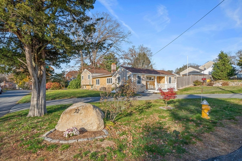


Welcome to this thoughtfully renovated Ranch style home in a highly sought after neighborhood. This home features a beautiful kitchen with 11ft island, granite countertops and stainless steel appliances that open to your new dining area and wood burning fireplaced living room! A perfect spot for entertaining or just relaxing in your new home. This residence features 3 bedrooms and 2 full baths making everyday living that much easier. The sunlit great room offers flexibility and ample space for hosting those larger gatherings. The lower level has nice sized windows and is perfect for a playroom, exercise space or home office? The fenced in backyard features extensive stone work (walls/patios) an inground pool to cool off on those hot summer days, gazebo, shed and garden area. Roof 2 yrs, heating system 3 yrs, new cooktop. A great commuter location with neighborhood access to schools and sports fields offering a unique opportunity to establish roots in this beautiful seaside town!
Last Agent to Sell the Property
F. Scott Crowley Real Estate LLC Listed on: 11/13/2025
| Date | Type | Sale Price | Title Company |
|---|---|---|---|
| Quit Claim Deed | $850,000 | -- | |
| Deed | $365,000 | -- | |
| Deed | $175,000 | -- | |
| Deed | $175,000 | -- |
| Date | Status | Loan Amount | Loan Type |
|---|---|---|---|
| Open | $595,000 | New Conventional | |
| Previous Owner | $265,000 | Purchase Money Mortgage | |
| Previous Owner | $296,000 | No Value Available | |
| Previous Owner | $170,000 | No Value Available |
| Date | Event | Price | List to Sale | Price per Sq Ft |
|---|---|---|---|---|
| 01/12/2026 01/12/26 | Sold | $850,000 | +6.3% | $407 / Sq Ft |
| 11/17/2025 11/17/25 | Pending | -- | -- | -- |
| 11/13/2025 11/13/25 | For Sale | $799,999 | -- | $384 / Sq Ft |
| Year | Tax Paid | Tax Assessment Tax Assessment Total Assessment is a certain percentage of the fair market value that is determined by local assessors to be the total taxable value of land and additions on the property. | Land | Improvement |
|---|---|---|---|---|
| 2025 | $5,106 | $511,100 | $365,300 | $145,800 |
| 2024 | $5,006 | $483,200 | $332,100 | $151,100 |
| 2023 | $5,328 | $460,400 | $318,700 | $141,700 |
| 2022 | $5,328 | $422,200 | $284,800 | $137,400 |
| 2021 | $5,251 | $393,900 | $271,200 | $122,700 |
| 2020 | $5,110 | $378,500 | $260,800 | $117,700 |
| 2019 | $5,109 | $371,800 | $255,600 | $116,200 |
| 2018 | $5,127 | $367,500 | $257,300 | $110,200 |
| 2017 | $5,027 | $356,800 | $246,600 | $110,200 |
| 2016 | $4,743 | $335,400 | $225,200 | $110,200 |
| 2015 | $4,252 | $324,600 | $214,400 | $110,200 |
Seller's Agent in 2026
F. Scott Crowley
F. Scott Crowley Real Estate LLC
(781) 635-4195
8 in this area
25 Total Sales
Source: MLS Property Information Network (MLS PIN)
MLS Number: 73454811
APN: SCIT-000032-000003-000008
Disclaimer: Certain information contained herein is derived from information provided by parties other than Homes.com. All information provided is deemed reliable, but is not guaranteed to be accurate and should be independently verified.
![]() The property listing data and information, or the Images, set forth herein were provided to MLS Property Information Network, Inc. from third party sources, including sellers, lessors and public records, and were compiled by MLS Property Information Network, Inc. The property listing data and information, and the Images, are for the personal, non-commercial use of consumers having a good faith interest in purchasing or leasing listed properties of the type displayed to them and may not be used for any purpose other than to identify prospective properties which such consumers may have a good faith interest in purchasing or leasing. MLS Property Information Network, Inc. and its subscribers disclaim any and all representations and warranties as to the accuracy of the property listing data and information, or as to the accuracy of any of the Images, set forth herein.
The property listing data and information, or the Images, set forth herein were provided to MLS Property Information Network, Inc. from third party sources, including sellers, lessors and public records, and were compiled by MLS Property Information Network, Inc. The property listing data and information, and the Images, are for the personal, non-commercial use of consumers having a good faith interest in purchasing or leasing listed properties of the type displayed to them and may not be used for any purpose other than to identify prospective properties which such consumers may have a good faith interest in purchasing or leasing. MLS Property Information Network, Inc. and its subscribers disclaim any and all representations and warranties as to the accuracy of the property listing data and information, or as to the accuracy of any of the Images, set forth herein.
Ask me questions while you tour the home.