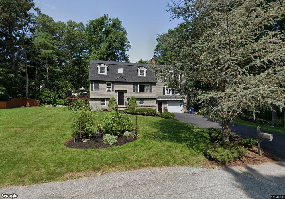
32 Fay St Wilmington, MA 01887
Estimated Value: $949,859 - $1,062,000
3
Beds
3
Baths
2,618
Sq Ft
$381/Sq Ft
Est. Value
About This Home
This home is located at 32 Fay St, Wilmington, MA 01887 and is currently estimated at $998,715, approximately $381 per square foot. 32 Fay St is a home located in Middlesex County with nearby schools including Wilmington Middle School, Wilmington High School, and Abundant Life Christian School and Childcare.
Ownership History
Date
Name
Owned For
Owner Type
Purchase Details
Closed on
Jan 6, 2022
Sold by
Steenbruggen John L and Steenbruggen Carol J
Bought by
Cz Stone Rt
Current Estimated Value
Purchase Details
Closed on
Apr 27, 1994
Sold by
Stewart John W and Stewart Margaret
Bought by
Mulberry Rt
Purchase Details
Closed on
Jul 24, 1987
Sold by
C & N Rt
Bought by
Mulberry Rt
Create a Home Valuation Report for This Property
The Home Valuation Report is an in-depth analysis detailing your home's value as well as a comparison with similar homes in the area
Home Values in the Area
Average Home Value in this Area
Purchase History
| Date | Buyer | Sale Price | Title Company |
|---|---|---|---|
| Cz Stone Rt | -- | None Available | |
| Mulberry Rt | $253,500 | -- | |
| Mulberry Rt | $64,675 | -- |
Source: Public Records
Mortgage History
| Date | Status | Borrower | Loan Amount |
|---|---|---|---|
| Previous Owner | Mulberry Rt | $170,000 | |
| Previous Owner | Mulberry Rt | $38,000 |
Source: Public Records
Tax History Compared to Growth
Tax History
| Year | Tax Paid | Tax Assessment Tax Assessment Total Assessment is a certain percentage of the fair market value that is determined by local assessors to be the total taxable value of land and additions on the property. | Land | Improvement |
|---|---|---|---|---|
| 2025 | $9,888 | $863,600 | $301,600 | $562,000 |
| 2024 | $9,433 | $825,300 | $301,600 | $523,700 |
| 2023 | $9,131 | $764,700 | $274,200 | $490,500 |
| 2022 | $8,735 | $670,400 | $228,500 | $441,900 |
| 2021 | $8,809 | $636,500 | $207,600 | $428,900 |
| 2020 | $8,970 | $660,500 | $207,600 | $452,900 |
| 2019 | $8,345 | $606,900 | $197,800 | $409,100 |
| 2018 | $8,122 | $556,500 | $188,400 | $368,100 |
| 2017 | $8,122 | $562,100 | $182,200 | $379,900 |
| 2016 | $7,564 | $517,000 | $173,600 | $343,400 |
| 2015 | $6,945 | $483,300 | $173,600 | $309,700 |
| 2014 | $6,444 | $452,500 | $165,300 | $287,200 |
Source: Public Records
Map
Nearby Homes
- 42 Dobson St
- 30 Fay St
- 31 Fay St
- 36 Dobson St
- 43 Dobson St
- 29 Fay St
- 41 Dobson St
- 28 Dobson St
- 35 Dobson St
- 24 Yentile Place Unit 24-AE,A
- 31 Yentile Place Unit 31
- 21 Yentile Place Unit 21 D,A
- 11 Yentile Place Unit 11 A,A
- 36 Yentile Place Unit 36,D
- LOT 9 Kylie Estates
- Lot ? McDonald Rd
- 27 Fay St
- 27 King St
- 27 King St Unit 27
- 27 King St Unit 1