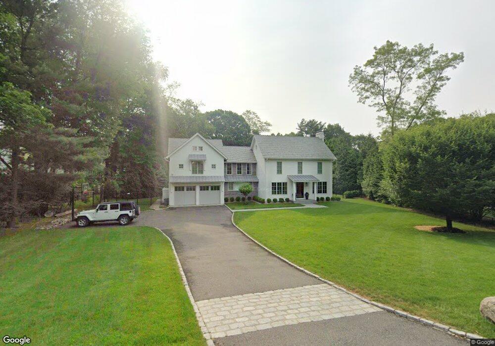
32 Ferry Ln E Westport, CT 06880
Saugatuck NeighborhoodEstimated Value: $2,710,000 - $2,971,000
4
Beds
5
Baths
3,370
Sq Ft
$838/Sq Ft
Est. Value
About This Home
This home is located at 32 Ferry Ln E, Westport, CT 06880 and is currently estimated at $2,823,838, approximately $837 per square foot. 32 Ferry Ln E is a home located in Fairfield County with nearby schools including Green's Farms School, Bedford Middle School, and Staples High School.
Ownership History
Date
Name
Owned For
Owner Type
Purchase Details
Closed on
May 19, 2014
Sold by
Link Jurgen W
Bought by
Link Barbara A
Current Estimated Value
Purchase Details
Closed on
May 25, 2012
Sold by
Link Jurgen W and Link Barbara A
Bought by
Ribolla Lino H and Desouza Aurea
Purchase Details
Closed on
Apr 29, 1999
Sold by
Oshman Marilyn
Bought by
Haberlin Page H and Haberlin Eugenea L
Purchase Details
Closed on
Dec 18, 1992
Sold by
Miller Russell and Miller Jody
Bought by
Lind Jurgen W
Purchase Details
Closed on
Aug 18, 1989
Sold by
Jackson Scott
Bought by
Miller Russell
Purchase Details
Closed on
Oct 26, 1987
Sold by
Smith Peter
Bought by
Jackson Scott
Create a Home Valuation Report for This Property
The Home Valuation Report is an in-depth analysis detailing your home's value as well as a comparison with similar homes in the area
Home Values in the Area
Average Home Value in this Area
Purchase History
| Date | Buyer | Sale Price | Title Company |
|---|---|---|---|
| Link Barbara A | -- | -- | |
| Link Barbara A | -- | -- | |
| Ribolla Lino H | -- | -- | |
| Ribolla Lino H | -- | -- | |
| Haberlin Page H | $245,000 | -- | |
| Haberlin Page H | $245,000 | -- | |
| Lind Jurgen W | $458,750 | -- | |
| Miller Russell | $425,000 | -- | |
| Jackson Scott | $462,500 | -- |
Source: Public Records
Mortgage History
| Date | Status | Borrower | Loan Amount |
|---|---|---|---|
| Previous Owner | Jackson Scott | $456,000 | |
| Previous Owner | Jackson Scott | $499,000 |
Source: Public Records
Tax History
| Year | Tax Paid | Tax Assessment Tax Assessment Total Assessment is a certain percentage of the fair market value that is determined by local assessors to be the total taxable value of land and additions on the property. | Land | Improvement |
|---|---|---|---|---|
| 2025 | $21,823 | $1,157,100 | $567,000 | $590,100 |
| 2024 | $15,645 | $840,200 | $567,000 | $273,200 |
| 2023 | $15,418 | $840,200 | $567,000 | $273,200 |
| 2022 | $15,182 | $840,200 | $567,000 | $273,200 |
| 2021 | $15,182 | $840,200 | $567,000 | $273,200 |
| 2020 | $14,867 | $889,700 | $598,500 | $291,200 |
| 2019 | $8,045 | $889,700 | $598,500 | $291,200 |
| 2018 | $8,769 | $889,700 | $598,500 | $291,200 |
| 2017 | $8,607 | $889,700 | $598,500 | $291,200 |
| 2016 | $15,000 | $889,700 | $598,500 | $291,200 |
| 2015 | $15,067 | $832,900 | $494,600 | $338,300 |
| 2014 | $14,942 | $832,900 | $494,600 | $338,300 |
Source: Public Records
Map
Nearby Homes
- 11 Manitou Ct
- 32 Narrow Rocks Rd
- 31 Franklin St
- 23 Bridge St
- 5 Franklin Ave
- 26 Treadwell Ave
- 3 Laurel Ln
- 24 Compo Pkwy
- 39 Compo Pkwy
- 7 Hale St
- 14 Owenoke Park
- 5 Inwood Ln
- 9 Pond Edge Rd
- 50 Kings Hwy S
- 150 Hillspoint Rd
- 102 Compo Rd S
- 80 County St Unit 9K
- 80 County St Unit 11K
- 5 Over Rock Ln
- 79 Riverside Ave
Your Personal Tour Guide
Ask me questions while you tour the home.