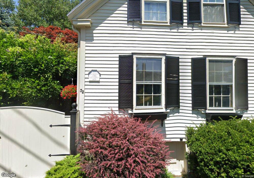
32 High St Marblehead, MA 01945
Estimated Value: $680,000 - $1,093,000
3
Beds
2
Baths
1,290
Sq Ft
$633/Sq Ft
Est. Value
About This Home
This home is located at 32 High St, Marblehead, MA 01945 and is currently estimated at $815,963, approximately $632 per square foot. 32 High St is a home located in Essex County with nearby schools including Marblehead High School, Marblehead Community Charter Public School, and Devereux School.
Ownership History
Date
Name
Owned For
Owner Type
Purchase Details
Closed on
Dec 29, 2025
Sold by
Greenwald David B and Horowitz Karen E
Bought by
Greenwald Horowitz Ret and Greenwald
Current Estimated Value
Purchase Details
Closed on
Jul 1, 1985
Bought by
Greenwald David Bruce and Horowitz Karen E
Create a Home Valuation Report for This Property
The Home Valuation Report is an in-depth analysis detailing your home's value as well as a comparison with similar homes in the area
Home Values in the Area
Average Home Value in this Area
Purchase History
| Date | Buyer | Sale Price | Title Company |
|---|---|---|---|
| Greenwald Horowitz Ret | -- | -- | |
| Greenwald David Bruce | -- | -- |
Source: Public Records
Mortgage History
| Date | Status | Borrower | Loan Amount |
|---|---|---|---|
| Previous Owner | Greenwald David Bruce | $170,000 | |
| Previous Owner | Greenwald David Bruce | $125,000 | |
| Previous Owner | Greenwald David Bruce | $65,000 |
Source: Public Records
Tax History
| Year | Tax Paid | Tax Assessment Tax Assessment Total Assessment is a certain percentage of the fair market value that is determined by local assessors to be the total taxable value of land and additions on the property. | Land | Improvement |
|---|---|---|---|---|
| 2025 | $7,663 | $846,700 | $620,800 | $225,900 |
| 2024 | $7,551 | $842,700 | $620,800 | $221,900 |
| 2023 | $7,203 | $720,300 | $534,800 | $185,500 |
| 2022 | $6,919 | $657,700 | $477,500 | $180,200 |
| 2021 | $6,741 | $646,900 | $468,000 | $178,900 |
| 2020 | $6,411 | $617,000 | $458,400 | $158,600 |
| 2019 | $6,319 | $588,400 | $429,800 | $158,600 |
| 2018 | $5,957 | $540,600 | $382,000 | $158,600 |
| 2017 | $5,742 | $521,500 | $362,900 | $158,600 |
| 2016 | $5,365 | $483,300 | $324,700 | $158,600 |
| 2015 | $5,181 | $467,600 | $305,600 | $162,000 |
| 2014 | $5,137 | $463,200 | $305,600 | $157,600 |
Source: Public Records
Map
Nearby Homes
- 7 Mechanic Ct
- 3 Frost Ln Unit 1
- 9 Darling St
- 45 Pleasant St
- 26 Summer St Unit 1
- 132 Elm St
- 132 Elm St Unit 132
- 66 Pleasant St Unit 1
- 66 Pleasant St Unit 2
- 9 Lincoln Park
- 55 Roosevelt Ave
- 55 Brackett Place Unit B
- 157 Green St Unit 3
- 290 Washington St Unit A
- 6 Mount Vernon St
- 41 Atlantic Ave Unit 1
- 7 Cottage St
- 4 Ballast Ln
- 4 Broadmere Way
- 349 Ocean Ave
Your Personal Tour Guide
Ask me questions while you tour the home.