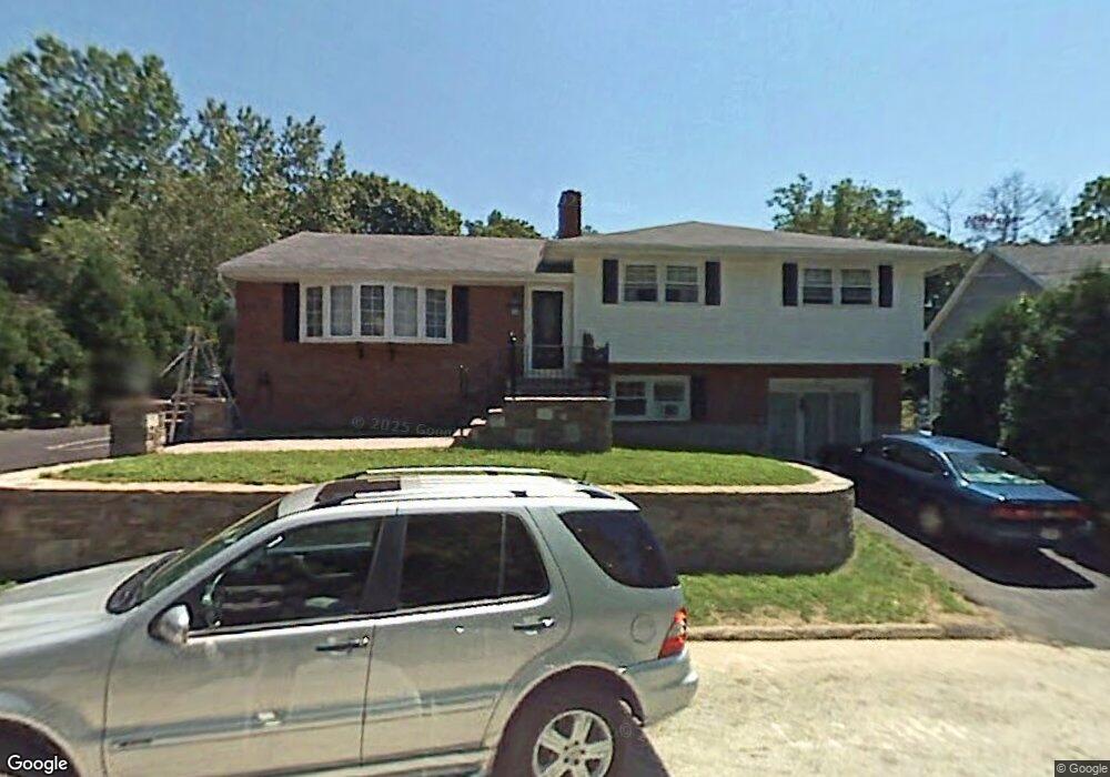
32 Jennings St Worcester, MA 01604
Grafton Hill NeighborhoodEstimated Value: $541,000 - $564,000
5
Beds
3
Baths
1,772
Sq Ft
$311/Sq Ft
Est. Value
About This Home
This home is located at 32 Jennings St, Worcester, MA 01604 and is currently estimated at $551,827, approximately $311 per square foot. 32 Jennings St is a home located in Worcester County with nearby schools including Roosevelt Elementary School, Jacob Hiatt Magnet School, and Chandler Magnet.
Ownership History
Date
Name
Owned For
Owner Type
Purchase Details
Closed on
Mar 14, 2016
Sold by
Hinson Sandra J
Bought by
Hinson Lt
Current Estimated Value
Create a Home Valuation Report for This Property
The Home Valuation Report is an in-depth analysis detailing your home's value as well as a comparison with similar homes in the area
Home Values in the Area
Average Home Value in this Area
Purchase History
| Date | Buyer | Sale Price | Title Company |
|---|---|---|---|
| Hinson Lt | -- | -- |
Source: Public Records
Tax History Compared to Growth
Tax History
| Year | Tax Paid | Tax Assessment Tax Assessment Total Assessment is a certain percentage of the fair market value that is determined by local assessors to be the total taxable value of land and additions on the property. | Land | Improvement |
|---|---|---|---|---|
| 2025 | $6,449 | $488,900 | $119,200 | $369,700 |
| 2024 | $6,281 | $456,800 | $119,200 | $337,600 |
| 2023 | $6,158 | $429,400 | $103,600 | $325,800 |
| 2022 | $5,395 | $354,700 | $82,900 | $271,800 |
| 2021 | $5,675 | $348,600 | $66,300 | $282,300 |
| 2020 | $5,426 | $319,200 | $66,300 | $252,900 |
| 2019 | $5,330 | $296,100 | $59,900 | $236,200 |
| 2018 | $5,361 | $283,500 | $59,900 | $223,600 |
| 2017 | $5,145 | $267,700 | $59,900 | $207,800 |
| 2016 | $5,177 | $251,200 | $45,000 | $206,200 |
| 2015 | $5,042 | $251,200 | $45,000 | $206,200 |
| 2014 | $4,908 | $251,200 | $45,000 | $206,200 |
Source: Public Records
Map
Nearby Homes
- 11 Phoenix St
- 24 Benham St Unit B
- 63 Progressive St
- 65 Progressive St
- 3 Lorenzo St
- 119 Orton Street Extension
- 21 Middlesex Ave Unit 102
- 21-23 Maranda St
- 25-27 Maranda St
- 25 Crawford St
- 334 Bridle Path
- 22 Anderson Ave
- 13 Elton St
- 15 Anderson Ave
- 496 Hamilton St
- 270 Sunderland Rd Unit 77
- 270 Sunderland Rd Unit 67
- 342 Lake Ave
- 4 Harold St
- 340 Hamilton St
- 28 Jennings St
- 36 Jennings St
- 26 Jennings St
- 13 A&B Jennings
- 16 Jennings St
- 19 Jennings St
- 19A Jennings St
- 21 Jennings St
- 22 Jennings St
- 19B Jennings St
- 17A Jennings St
- 17B Jennings St
- 17 Jennings St
- 15 Jennings St
- 4 Orton St
- 143 Commonwealth Ave
- 13 Jennings St
- 145 Commonwealth Ave
- 16 Angelo St
- 139B Commonwealth Ave