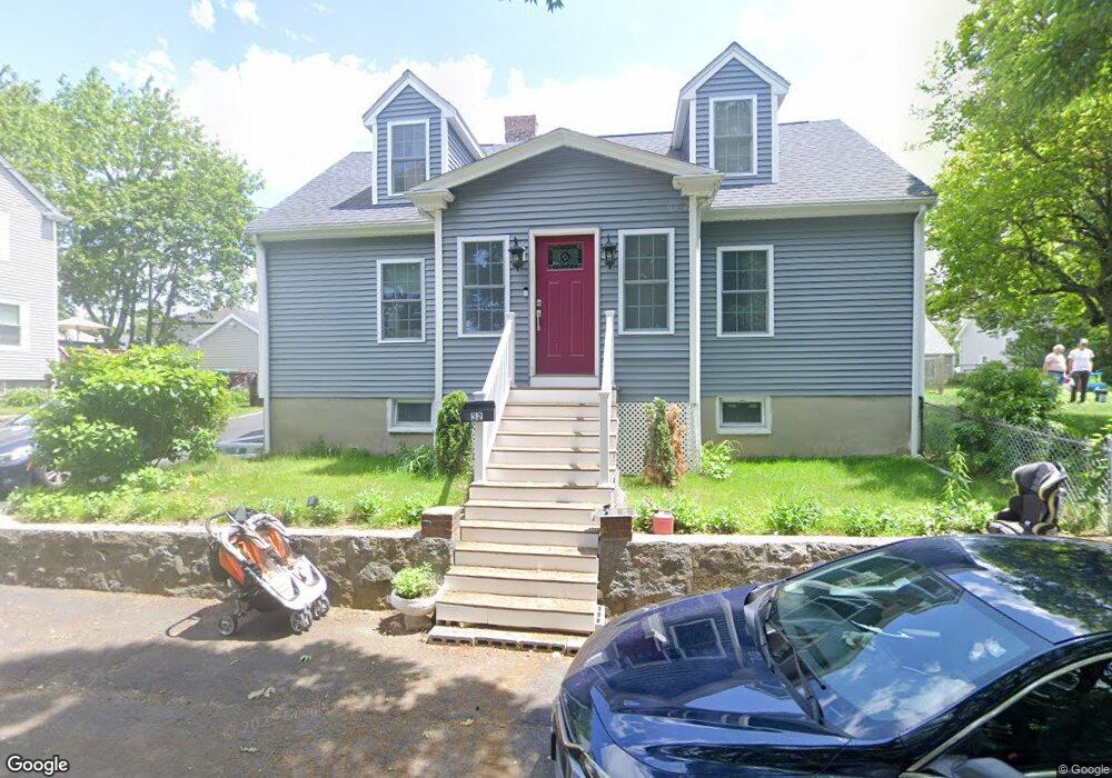
32 Ridge Ave Dedham, MA 02026
East Dedham NeighborhoodEstimated Value: $625,000 - $645,000
4
Beds
1
Bath
1,520
Sq Ft
$417/Sq Ft
Est. Value
About This Home
This home is located at 32 Ridge Ave, Dedham, MA 02026 and is currently estimated at $633,432, approximately $416 per square foot. 32 Ridge Ave is a home located in Norfolk County with nearby schools including Avery, Dedham Middle School, and Dedham High School.
Ownership History
Date
Name
Owned For
Owner Type
Purchase Details
Closed on
Sep 10, 2020
Sold by
Mcneil Rt
Bought by
Hasnaoui Khalid E
Current Estimated Value
Purchase Details
Closed on
Jul 10, 2012
Sold by
Mcneil Walter J and Mcneil Elizabeth A
Bought by
Mcneil Rt and Mcneil Walter J
Purchase Details
Closed on
Apr 27, 2006
Sold by
Mcneil Walter J and Mcneil Elizabeth A
Bought by
Mcneil Walter J and Mcneil Elizabeth A
Create a Home Valuation Report for This Property
The Home Valuation Report is an in-depth analysis detailing your home's value as well as a comparison with similar homes in the area
Home Values in the Area
Average Home Value in this Area
Purchase History
| Date | Buyer | Sale Price | Title Company |
|---|---|---|---|
| Hasnaoui Khalid E | $350,000 | None Available | |
| Mcneil Rt | -- | -- | |
| Mcneil Walter J | -- | -- |
Source: Public Records
Tax History
| Year | Tax Paid | Tax Assessment Tax Assessment Total Assessment is a certain percentage of the fair market value that is determined by local assessors to be the total taxable value of land and additions on the property. | Land | Improvement |
|---|---|---|---|---|
| 2025 | $6,926 | $548,800 | $277,900 | $270,900 |
| 2024 | $6,951 | $556,100 | $263,200 | $292,900 |
| 2023 | $6,496 | $505,900 | $233,700 | $272,200 |
| 2022 | $6,225 | $466,300 | $228,700 | $237,600 |
| 2021 | $5,845 | $427,600 | $223,800 | $203,800 |
| 2020 | $5,703 | $415,700 | $213,900 | $201,800 |
| 2019 | $5,295 | $374,200 | $186,100 | $188,100 |
| 2018 | $5,053 | $347,300 | $164,500 | $182,800 |
| 2017 | $4,971 | $336,800 | $154,000 | $182,800 |
| 2016 | $4,673 | $301,700 | $134,400 | $167,300 |
| 2015 | $4,485 | $282,600 | $132,300 | $150,300 |
| 2014 | $4,335 | $269,600 | $129,300 | $140,300 |
Source: Public Records
Map
Nearby Homes
- 111 Schiller Rd
- 8 Sumner St
- 25 Rockland St Unit 5
- 25R Rockland St Unit 6
- 94 Rockland St
- 109 Rockland St
- 4 Mount Hope St
- 49 Greenhood St
- 231 Grove St
- 42 Churchill Place
- 153 Colburn St
- 5170 Washington St Unit 107
- 231-245 Grove St
- 442 High St
- 28 Linden Place
- 191 Glenellen Rd
- 108 High St
- 41 Vogel St
- 132 Whitehall St
- 150 Grove St
- 89 Schiller Rd
- 46 Ridge Ave
- 93 Schiller Rd
- 30 Ridge Ave
- 85 Schiller Rd
- 97 Schiller Rd
- 83 Schiller Rd
- 26 Ridge Ave
- 26 Ridge Ave Unit 2
- 27 Ridge Ave
- 77 Schiller Rd
- 9 Columbia Terrace
- 107 Schiller Rd
- 92 Schiller Rd
- 86 Schiller Rd
- 18 Ridge Ave
- 23 Ridge Ave
- 28 Ridge Ave Unit 2
- 96 Schiller Rd
- 7 Columbia Terrace
Your Personal Tour Guide
Ask me questions while you tour the home.