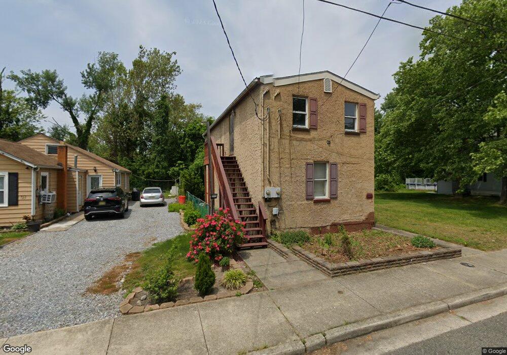
32 S Smith Ave Penns Grove, NJ 08069
Estimated Value: $131,875 - $193,000
--
Bed
--
Bath
1,280
Sq Ft
$129/Sq Ft
Est. Value
About This Home
This home is located at 32 S Smith Ave, Penns Grove, NJ 08069 and is currently estimated at $164,969, approximately $128 per square foot. 32 S Smith Ave is a home located in Salem County with nearby schools including Lafayette-Pershing Elementary School, Paul W. Carleton Elementary School, and Field Street Elementary School.
Ownership History
Date
Name
Owned For
Owner Type
Purchase Details
Closed on
Nov 27, 2006
Sold by
Belanger Scott C and Belanger Donna E
Bought by
Schemanski Glen
Current Estimated Value
Home Financials for this Owner
Home Financials are based on the most recent Mortgage that was taken out on this home.
Original Mortgage
$135,000
Outstanding Balance
$94,836
Interest Rate
9.74%
Mortgage Type
Purchase Money Mortgage
Estimated Equity
$70,133
Purchase Details
Closed on
Feb 21, 2002
Sold by
Benner Tammy
Bought by
Leghorn Robert S and Leghorn Maureen
Home Financials for this Owner
Home Financials are based on the most recent Mortgage that was taken out on this home.
Original Mortgage
$53,900
Interest Rate
6.57%
Mortgage Type
Stand Alone First
Purchase Details
Closed on
Oct 28, 1999
Sold by
Driver George E
Bought by
Benner Tammy
Create a Home Valuation Report for This Property
The Home Valuation Report is an in-depth analysis detailing your home's value as well as a comparison with similar homes in the area
Home Values in the Area
Average Home Value in this Area
Purchase History
| Date | Buyer | Sale Price | Title Company |
|---|---|---|---|
| Schemanski Glen | $135,000 | None Available | |
| Leghorn Robert S | $59,900 | -- | |
| Benner Tammy | $13,000 | Salem Oak Title Agency Inc |
Source: Public Records
Mortgage History
| Date | Status | Borrower | Loan Amount |
|---|---|---|---|
| Open | Schemanski Glen | $135,000 | |
| Previous Owner | Leghorn Robert S | $53,900 |
Source: Public Records
Tax History Compared to Growth
Tax History
| Year | Tax Paid | Tax Assessment Tax Assessment Total Assessment is a certain percentage of the fair market value that is determined by local assessors to be the total taxable value of land and additions on the property. | Land | Improvement |
|---|---|---|---|---|
| 2025 | $2,657 | $47,900 | $9,600 | $38,300 |
| 2024 | $2,567 | $47,900 | $9,600 | $38,300 |
| 2023 | $2,567 | $47,900 | $9,600 | $38,300 |
| 2022 | $2,475 | $47,900 | $9,600 | $38,300 |
| 2021 | $2,368 | $47,900 | $9,600 | $38,300 |
| 2020 | $2,399 | $47,900 | $9,600 | $38,300 |
| 2019 | $2,409 | $47,900 | $9,600 | $38,300 |
| 2018 | $3,836 | $95,100 | $17,600 | $77,500 |
| 2017 | $3,850 | $95,100 | $17,600 | $77,500 |
| 2016 | $3,704 | $95,100 | $17,600 | $77,500 |
| 2015 | $3,548 | $95,100 | $17,600 | $77,500 |
| 2014 | $3,509 | $95,100 | $17,600 | $77,500 |
Source: Public Records
Map
Nearby Homes
- 39 41 Cumberland Ave
- 34 38 Cumberland Ave
- 59-61 Walnut St
- 32 Walnut St
- 55 57 Walnut St
- 0 Lincoln Avenue & Cumberland
- 114 Deming Ave
- 0 Cumberland Ave
- 83 Willis St
- 32 Westminster Ave
- 15 Walnut St
- 45 S Virginia Ave
- 80 S Broad St
- 106 S Broad St
- 65 S Broad St
- 0 Park Ave Unit NJSA2013690
- 85 State St
- 106 Sack Ave
- 3 Naylor Ave
- 88 Railroad Ave
- 38 S Smith Ave
- 39 Cumberland Ave Unit 41
- 24 S Smith Ave
- 71 Walnut St
- 37 S Smith Ave
- 39 Cumberland Ave
- 39 S Smith Ave
- 20 S Smith Ave
- 17 S Smith Ave
- 19 S Smith Ave
- 69 Walnut St
- 18 S Smith Ave
- 65 Walnut St
- 11 S Smith Ave
- 81 Walnut St
- 28 Cumberland Ave
- 26 Cumberland Ave Unit 28
- 0 Lincoln Avenue (Lots 4 5 6 7 & 8)
- 9 S Smith Ave
- 14 S Smith Ave