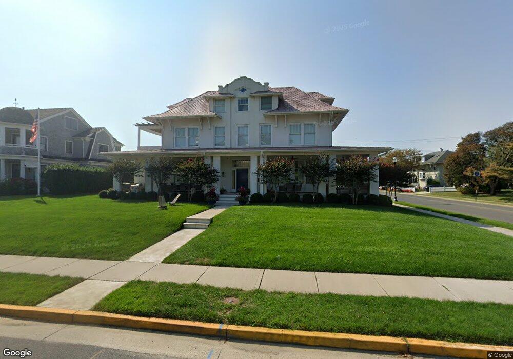
32 Spier Ave Allenhurst, NJ 07711
Estimated Value: $5,127,000 - $7,782,913
7
Beds
7
Baths
4,400
Sq Ft
$1,414/Sq Ft
Est. Value
About This Home
This home is located at 32 Spier Ave, Allenhurst, NJ 07711 and is currently estimated at $6,222,638, approximately $1,414 per square foot. 32 Spier Ave is a home with nearby schools including Hope Academy Charter School, St. Mary of the Assumption School, and Bnot Shirah of Deal.
Ownership History
Date
Name
Owned For
Owner Type
Purchase Details
Closed on
Dec 8, 2025
Sold by
Zeitouni Gabriel
Bought by
Zeitouni Sophia
Current Estimated Value
Purchase Details
Closed on
Oct 28, 2016
Sold by
Gindi Irwin Ralph
Bought by
Zeitouni Gabriel M
Purchase Details
Closed on
Jan 10, 2008
Sold by
Mauro Anthony
Bought by
Gindi Irwin Ralph
Create a Home Valuation Report for This Property
The Home Valuation Report is an in-depth analysis detailing your home's value as well as a comparison with similar homes in the area
Home Values in the Area
Average Home Value in this Area
Purchase History
| Date | Buyer | Sale Price | Title Company |
|---|---|---|---|
| Zeitouni Sophia | -- | Zenith Abstract | |
| Zeitouni Gabriel M | $1,400,000 | -- | |
| Gindi Irwin Ralph | $3,600,000 | None Available |
Source: Public Records
Tax History
| Year | Tax Paid | Tax Assessment Tax Assessment Total Assessment is a certain percentage of the fair market value that is determined by local assessors to be the total taxable value of land and additions on the property. | Land | Improvement |
|---|---|---|---|---|
| 2025 | $29,654 | $5,342,400 | $3,762,100 | $1,580,300 |
| 2024 | $25,188 | $5,034,700 | $3,432,900 | $1,601,800 |
| 2023 | $25,188 | $4,036,500 | $2,516,100 | $1,520,400 |
| 2022 | $23,482 | $3,527,100 | $2,170,400 | $1,356,700 |
| 2021 | $23,482 | $3,102,000 | $1,884,800 | $1,217,200 |
| 2020 | $22,456 | $2,838,900 | $1,659,400 | $1,179,500 |
| 2019 | $11,779 | $1,481,600 | $1,481,600 | $0 |
| 2018 | $11,104 | $1,395,000 | $1,395,000 | $0 |
| 2017 | $10,963 | $1,409,100 | $1,409,100 | $0 |
| 2016 | $10,763 | $1,293,600 | $1,293,600 | $0 |
| 2015 | $10,649 | $1,155,000 | $1,155,000 | $0 |
| 2014 | $10,741 | $1,263,600 | $1,263,600 | $0 |
Source: Public Records
Map
Nearby Homes
- 110 Corlies Ave Unit A
- 25 Cedar Ave
- 48 Neptune Ave
- 127 Cedar Ave
- 112 Euclid Ave
- 205 Edgemont Dr Unit 1
- 205 Edgemont Dr Unit 2
- 205 Edgemont Dr Unit 3
- 205 Edgemont Dr Unit BUILDING
- 57 Hathaway Ave
- 315 Allen Ave
- 309 Elberon Ave
- 309 Hume St
- 304 Deal Lake Dr Unit 35
- 300 Deal Lake Dr Unit 16
- 302 Deal Lake Dr Unit 20
- 302 Deal Lake Dr Unit 18
- 400 Deal Lake Dr Unit 3J
- 400 Deal Lake Dr Unit 6G
- 400 Deal Lake Dr Unit 8F
Your Personal Tour Guide
Ask me questions while you tour the home.