


32 Staaf Rd Saugus, MA 01906
Cliftondale NeighborhoodEstimated payment $3,601/month
Highlights
- Medical Services
- Deck
- Ranch Style House
- 0.32 Acre Lot
- Property is near public transit
- Wood Flooring
About This Home
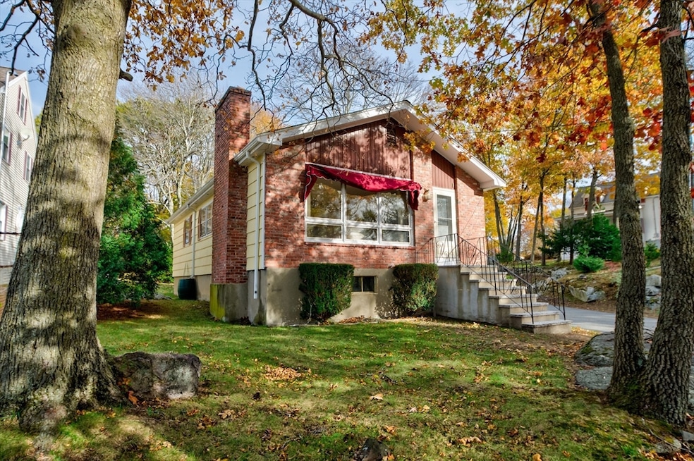
Welcome to 32 Staaf Road in Saugus, a beautiful home that perfectly blends comfort, style, and convenience. This freshly painted 3-bedroom, 1-bath home sits on an oversized lot, offering plenty of space for kids to play, family gatherings, or future expansion. From the moment you arrive, you’ll notice the care that’s gone into maintaining this property. The rebuilt granite stairs lead to a bright and welcoming interior, while the newer roof, furnace, and hot water tank mean you can move right in without worry. Located just minutes from the highway and a short drive to Boston, this home provides the ideal balance of peaceful suburban living and city accessibility. Whether you’re starting a family or looking for a place to settle down, 32 Staaf Road has everything you need to feel right at home. Don’t miss your chance to make lasting memories in this charming Saugus gem.
Home Details
Home Type
- Single Family
Est. Annual Taxes
- $5,361
Year Built
- Built in 1968
Lot Details
- 0.32 Acre Lot
- Corner Lot
- Property is zoned NA
Home Design
- Ranch Style House
- Brick Exterior Construction
- Frame Construction
- Blown Fiberglass Insulation
- Shingle Roof
- Concrete Perimeter Foundation
Interior Spaces
- 984 Sq Ft Home
- 1 Fireplace
Kitchen
- Range
- Microwave
- Dishwasher
Flooring
- Wood
- Tile
- Vinyl
Bedrooms and Bathrooms
- 3 Bedrooms
- 1 Full Bathroom
Laundry
- Dryer
- Washer
Unfinished Basement
- Basement Fills Entire Space Under The House
- Laundry in Basement
Parking
- 2 Car Parking Spaces
- Off-Street Parking
Outdoor Features
- Deck
- Outdoor Storage
Location
- Property is near public transit
Schools
- Saugus High School
Utilities
- Window Unit Cooling System
- 1 Heating Zone
- Baseboard Heating
- Water Heater
- High Speed Internet
Listing and Financial Details
- Assessor Parcel Number 2152389
Community Details
Overview
- No Home Owners Association
Amenities
- Medical Services
- Shops
Map
Home Values in the Area
Average Home Value in this Area
Tax History
| Year | Tax Paid | Tax Assessment Tax Assessment Total Assessment is a certain percentage of the fair market value that is determined by local assessors to be the total taxable value of land and additions on the property. | Land | Improvement |
|---|---|---|---|---|
| 2025 | $5,361 | $502,000 | $314,400 | $187,600 |
| 2024 | $5,119 | $480,700 | $296,400 | $184,300 |
| 2023 | $4,932 | $438,000 | $260,500 | $177,500 |
| 2022 | $4,794 | $399,200 | $238,900 | $160,300 |
| 2021 | $4,539 | $367,800 | $207,500 | $160,300 |
| 2020 | $4,191 | $351,600 | $197,600 | $154,000 |
| 2019 | $3,993 | $327,800 | $179,700 | $148,100 |
| 2018 | $3,665 | $316,500 | $174,300 | $142,200 |
| 2017 | $3,373 | $279,900 | $162,600 | $117,300 |
| 2016 | $3,335 | $273,400 | $162,300 | $111,100 |
| 2015 | $3,129 | $260,300 | $154,500 | $105,800 |
| 2014 | $2,957 | $254,700 | $154,500 | $100,200 |
Property History
| Date | Event | Price | List to Sale | Price per Sq Ft |
|---|---|---|---|---|
| 11/09/2025 11/09/25 | For Sale | $599,000 | -- | $609 / Sq Ft |
Purchase History
| Date | Type | Sale Price | Title Company |
|---|---|---|---|
| Quit Claim Deed | -- | -- | |
| Quit Claim Deed | -- | -- | |
| Quit Claim Deed | -- | -- | |
| Quit Claim Deed | -- | -- | |
| Deed | -- | -- |
Mortgage History
| Date | Status | Loan Amount | Loan Type |
|---|---|---|---|
| Previous Owner | $25,000 | No Value Available |
Source: MLS Property Information Network (MLS PIN)
MLS Number: 73453103
APN: SAUG-000005E-000015-000026
Disclaimer: Certain information contained herein is derived from information provided by parties other than Homes.com. All information provided is deemed reliable, but is not guaranteed to be accurate and should be independently verified.
![]() The property listing data and information, or the Images, set forth herein were provided to MLS Property Information Network, Inc. from third party sources, including sellers, lessors and public records, and were compiled by MLS Property Information Network, Inc. The property listing data and information, and the Images, are for the personal, non-commercial use of consumers having a good faith interest in purchasing or leasing listed properties of the type displayed to them and may not be used for any purpose other than to identify prospective properties which such consumers may have a good faith interest in purchasing or leasing. MLS Property Information Network, Inc. and its subscribers disclaim any and all representations and warranties as to the accuracy of the property listing data and information, or as to the accuracy of any of the Images, set forth herein.
The property listing data and information, or the Images, set forth herein were provided to MLS Property Information Network, Inc. from third party sources, including sellers, lessors and public records, and were compiled by MLS Property Information Network, Inc. The property listing data and information, and the Images, are for the personal, non-commercial use of consumers having a good faith interest in purchasing or leasing listed properties of the type displayed to them and may not be used for any purpose other than to identify prospective properties which such consumers may have a good faith interest in purchasing or leasing. MLS Property Information Network, Inc. and its subscribers disclaim any and all representations and warranties as to the accuracy of the property listing data and information, or as to the accuracy of any of the Images, set forth herein.
- 86 School St
- 20 Oak Hill Rd
- 4 Foss Ave
- 483 Central St Unit A
- 32-34 Mount Vernon St
- 28 Eustis St
- 166 Essex St
- 171 Essex St
- 7 Davis St
- 292 Salem St Unit 503
- 292 Salem St Unit 101
- 9 Oakwood Ave
- 6 Sim Rd Unit 1
- 22 Laconia Ave
- 18 Nason Rd
- 6 Saugus Ave Unit A
- 22 Walnut St
- 40 Grand View Ave
- 184 Breedens Ln
- 13 Seaview Ave
- 498 Lincoln Ave Unit 2L
- 15 Linwood St Unit 1
- 12 Endicott St
- 411 Central St
- 35 Endicott St Unit 1
- 9 Bagnall Ave
- 27 Park St
- 118 Vine St Unit 2
- 179 Winter St Unit 1
- 1565 Broadway
- 193 Winter St Unit 1
- 333 Central St Unit 1H
- 333 Central St
- 11 Overlook Ridge Dr
- 1 Lawndale Ave Unit 1b
- 10 Overlook Ridge Dr
- 21 Quarry Ln
- 14 Winter St Unit 1
- 30 Serino Way Unit 1
- 11 Taylor St Unit A
