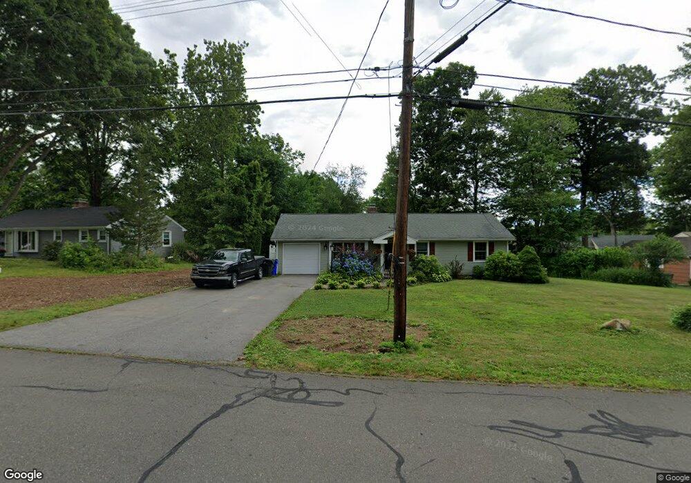
32 Timber Trail Wethersfield, CT 06109
Estimated Value: $307,000 - $399,000
3
Beds
2
Baths
1,362
Sq Ft
$264/Sq Ft
Est. Value
About This Home
This home is located at 32 Timber Trail, Wethersfield, CT 06109 and is currently estimated at $360,191, approximately $264 per square foot. 32 Timber Trail is a home located in Hartford County with nearby schools including Samuel B. Webb Elementary School, Silas Deane Middle School, and Wethersfield High School.
Ownership History
Date
Name
Owned For
Owner Type
Purchase Details
Closed on
Sep 30, 1999
Sold by
Mcdonough James M and Mcdonough Sheryl
Bought by
Czarnecki Kevin J
Current Estimated Value
Purchase Details
Closed on
Jul 12, 1994
Sold by
Miller Muriel D
Bought by
Mcdonough James M and Mcdonough Sheryl
Create a Home Valuation Report for This Property
The Home Valuation Report is an in-depth analysis detailing your home's value as well as a comparison with similar homes in the area
Home Values in the Area
Average Home Value in this Area
Purchase History
| Date | Buyer | Sale Price | Title Company |
|---|---|---|---|
| Czarnecki Kevin J | $114,000 | -- | |
| Mcdonough James M | $105,000 | -- |
Source: Public Records
Mortgage History
| Date | Status | Borrower | Loan Amount |
|---|---|---|---|
| Open | Mcdonough James M | $110,290 | |
| Closed | Mcdonough James M | $25,000 | |
| Closed | Mcdonough James M | $130,000 |
Source: Public Records
Tax History
| Year | Tax Paid | Tax Assessment Tax Assessment Total Assessment is a certain percentage of the fair market value that is determined by local assessors to be the total taxable value of land and additions on the property. | Land | Improvement |
|---|---|---|---|---|
| 2025 | $10,144 | $246,100 | $100,940 | $145,160 |
| 2024 | $6,505 | $150,510 | $66,460 | $84,050 |
| 2023 | $6,288 | $150,510 | $66,460 | $84,050 |
| 2022 | $6,183 | $150,510 | $66,460 | $84,050 |
| 2021 | $6,121 | $150,510 | $66,460 | $84,050 |
| 2020 | $6,124 | $150,510 | $66,460 | $84,050 |
| 2019 | $6,033 | $148,090 | $66,460 | $81,630 |
| 2018 | $6,174 | $151,400 | $65,800 | $85,600 |
| 2017 | $6,021 | $151,400 | $65,800 | $85,600 |
| 2016 | $5,835 | $151,400 | $65,800 | $85,600 |
| 2015 | $5,782 | $151,400 | $65,800 | $85,600 |
| 2014 | $5,562 | $151,400 | $65,800 | $85,600 |
Source: Public Records
Map
Nearby Homes
- 273 Forest Dr
- 20 Forest Dr
- 173 Timber Trail
- 35 Kingston St
- 295 Ridge Rd Unit 8
- 39 Schoolhouse Crossing
- 116 Wells Farm Dr
- 104 Willow St
- 249 Ridge Rd
- 7 Barrington Dr Unit C
- 48 Ridge Crest Cir
- 1310 Berlin Turnpike Unit 223
- 19 Albert Ave
- 455 Brimfield Rd
- 137 Dale Rd
- 274 Cedarwood Ln
- 192 Wolcott Hill Rd
- 79 Piper Brook Ave
- 89 Merriman Rd
- 90 Goodwin Park Rd
Your Personal Tour Guide
Ask me questions while you tour the home.