
Seller's Agent in 2025
Barbra Weisman
Compass
(508) 423-7155
3 in this area
34 Total Sales
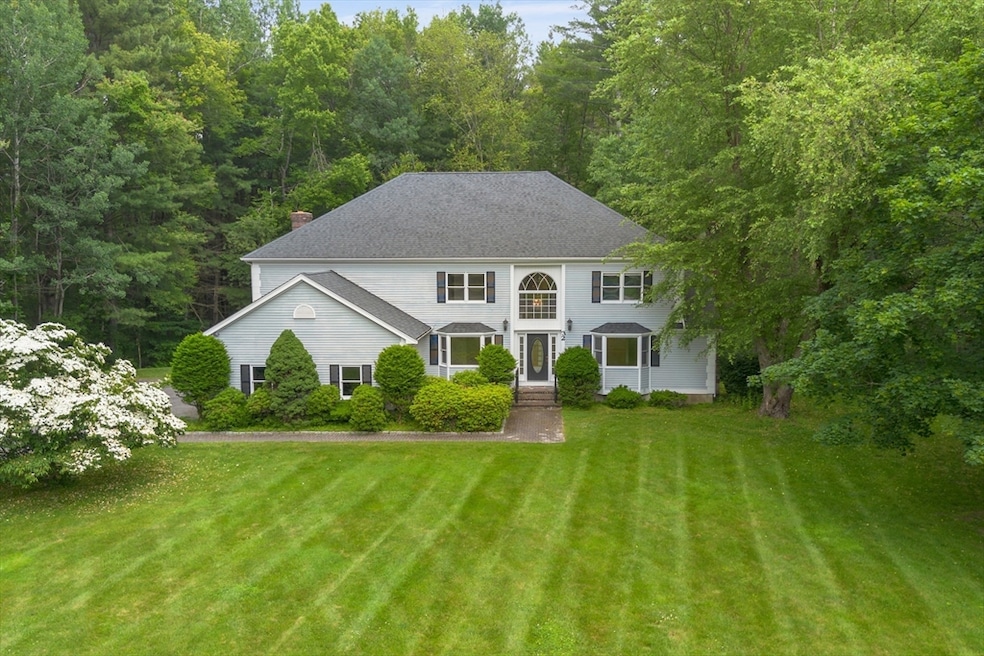
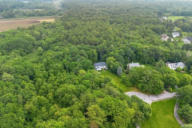
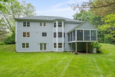
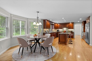

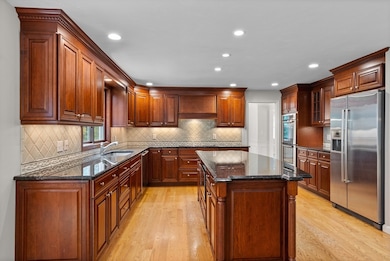
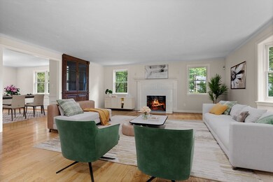
Nestled at the end of a gorgeous cul-de-sac in a favorite North Sudbury neighborhood, this spacious, custom-built colonial on 5 acres offers an A-plus setting and a fabulous opportunity. Hardwood floors, two fireplaces, and bay windows enhance its timeless appeal. A chef’s kitchen features Bosch appliances, double wall ovens, a large island, & dining area w/ tranquil views. The family room leads to a screened-in porch, perfect for enjoying lazy summer days. Spacious living & dining rooms are ideal for entertaining, while the separate office with custom built-ins provides a perfect workspace. The 2nd floor has a spacious primary suite which includes a sitting room, a generous-sized bath, and two large walk-in closets. Three more good-sized bedrooms and hall bath complete the floor. The finished walk-out LL is filled with natural light and has views of the private yard. Conveniently located near Sudbury's top-ranked schools, RTS. 2 & 117. Don't miss the chance to make this your own!
| Date | Type | Sale Price | Title Company |
|---|---|---|---|
| Deed | $1,362,000 | -- | |
| Deed | $1,362,000 | -- | |
| Deed | -- | None Available | |
| Deed | -- | None Available |
| Date | Status | Loan Amount | Loan Type |
|---|---|---|---|
| Open | $962,000 | New Conventional | |
| Closed | $962,000 | New Conventional |
| Date | Event | Price | List to Sale | Price per Sq Ft |
|---|---|---|---|---|
| 08/07/2025 08/07/25 | Sold | $1,362,000 | -2.7% | $264 / Sq Ft |
| 06/25/2025 06/25/25 | Pending | -- | -- | -- |
| 06/11/2025 06/11/25 | For Sale | $1,400,000 | -- | $271 / Sq Ft |
| Year | Tax Paid | Tax Assessment Tax Assessment Total Assessment is a certain percentage of the fair market value that is determined by local assessors to be the total taxable value of land and additions on the property. | Land | Improvement |
|---|---|---|---|---|
| 2025 | $23,084 | $1,576,800 | $502,900 | $1,073,900 |
| 2024 | $22,201 | $1,519,600 | $488,500 | $1,031,100 |
| 2023 | $20,488 | $1,299,200 | $436,500 | $862,700 |
| 2022 | $19,651 | $1,088,700 | $400,500 | $688,200 |
| 2021 | $18,758 | $996,200 | $400,500 | $595,700 |
| 2020 | $18,380 | $996,200 | $400,500 | $595,700 |
| 2019 | $17,842 | $996,200 | $400,500 | $595,700 |
| 2018 | $17,387 | $969,700 | $426,100 | $543,600 |
| 2017 | $17,046 | $960,900 | $422,500 | $538,400 |
| 2016 | $16,540 | $929,200 | $406,500 | $522,700 |
| 2015 | $15,995 | $908,800 | $394,900 | $513,900 |
| 2014 | $15,985 | $886,600 | $383,300 | $503,300 |
Seller's Agent in 2025
Barbra Weisman
Compass
(508) 423-7155
3 in this area
34 Total Sales
Buyer's Agent in 2025
Mckenzie Howarth
Coldwell Banker Realty - Newton
(617) 969-2447
1 in this area
106 Total Sales
Source: MLS Property Information Network (MLS PIN)
MLS Number: 73389727
APN: SUDB-000010D-000000-000604
Disclaimer: Certain information contained herein is derived from information provided by parties other than Homes.com. All information provided is deemed reliable, but is not guaranteed to be accurate and should be independently verified.
![]() The property listing data and information, or the Images, set forth herein were provided to MLS Property Information Network, Inc. from third party sources, including sellers, lessors and public records, and were compiled by MLS Property Information Network, Inc. The property listing data and information, and the Images, are for the personal, non-commercial use of consumers having a good faith interest in purchasing or leasing listed properties of the type displayed to them and may not be used for any purpose other than to identify prospective properties which such consumers may have a good faith interest in purchasing or leasing. MLS Property Information Network, Inc. and its subscribers disclaim any and all representations and warranties as to the accuracy of the property listing data and information, or as to the accuracy of any of the Images, set forth herein.
The property listing data and information, or the Images, set forth herein were provided to MLS Property Information Network, Inc. from third party sources, including sellers, lessors and public records, and were compiled by MLS Property Information Network, Inc. The property listing data and information, and the Images, are for the personal, non-commercial use of consumers having a good faith interest in purchasing or leasing listed properties of the type displayed to them and may not be used for any purpose other than to identify prospective properties which such consumers may have a good faith interest in purchasing or leasing. MLS Property Information Network, Inc. and its subscribers disclaim any and all representations and warranties as to the accuracy of the property listing data and information, or as to the accuracy of any of the Images, set forth herein.